Framed Print > Asia > Pakistan > Maps
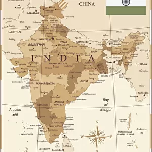
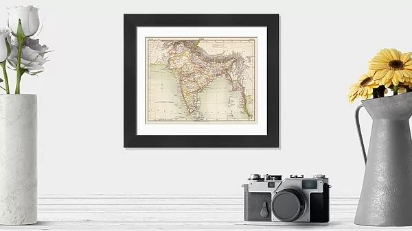
Framed Print : India map 1881


![]()
Framed Photos from Fine Art Storehouse
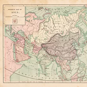
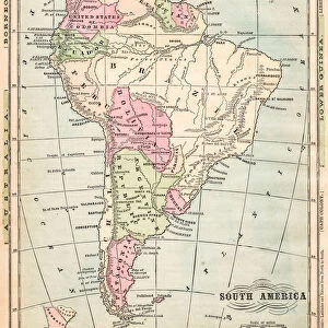
India map 1881
Encyclopedia Britannica 9th Edition Vol XII Philadelphia j.M. Stoddart & Co 1881
Unleash your creativity and transform your space into a visual masterpiece!
THEPALMER
Media ID 13611521
© This content is subject to copyright
India Pakistan Paper World Map
14"x12" (38x32cm) Modern Frame
Step back in time with our exquisite 'India Map 1881' Framed Print from ThePalmer at Media Storehouse. This vintage map, originally published in the Encyclopedia Britannica 9th Edition Vol XII, Philadelphia by J.M. Stoddart & Co in 1881, offers a captivating glimpse into the historical geography of India during that era. The intricate details and authentic antique look add an elegant touch to any room, making it a perfect addition to your home or office decor. Revive the past with this unique piece of historical art.
Wood effect frame, card mounted, 10x8 archival quality photo print. Overall outside dimensions 14x12 inches (38x32cm). Environmentally and ozone friendly, 40mm wide x 15mm Polycore® moulding has the look of real wood, is durable and light and easy to hang. Biodegradable and made with non-chlorinated gases (no toxic fumes) it is efficient; producing 100 tons of polystyrene can save 300 tons of trees! Prints are glazed with lightweight, shatterproof, optical clarity acrylic (providing the same general protection from the environment as glass). The back is stapled hardboard with a sawtooth hanger attached. Note: To minimise original artwork cropping, for optimum layout, and to ensure print is secure, the visible print may be marginally smaller
Contemporary Framed and Mounted Prints - Professionally Made and Ready to Hang
Estimated Image Size (if not cropped) is 24.4cm x 18.2cm (9.6" x 7.2")
Estimated Product Size is 37.6cm x 32.5cm (14.8" x 12.8")
These are individually made so all sizes are approximate
Artwork printed orientated as per the preview above, with landscape (horizontal) orientation to match the source image.
FEATURES IN THESE COLLECTIONS
> Fine Art Storehouse
> The Magical World of Illustration
> Palmer Illustrated Collection
> Fine Art Storehouse
> Map
> Historical Maps
> Asia
> India
> Related Images
> Asia
> Pakistan
> Related Images
> Maps and Charts
> India
> Maps and Charts
> Related Images
> Maps and Charts
> World
> North America
> United States of America
> Maps
EDITORS COMMENTS
This print takes us back in time to the year 1881, showcasing an exquisite illustration of the India map. Derived from the renowned Encyclopedia Britannica's 9th Edition Volume XII, Philadelphia-based publishers J. M. Stoddart & Co meticulously crafted this piece of cartographic artistry. The print captures a horizontal view of the map, displaying not only India but also neighboring countries such as Pakistan and even stretching across continents to include parts of the United States. Printed on high-quality paper, this antique gem showcases intricate details that transport us into a world where physical geography was explored through engravings and illustrations. Every contour and boundary is delicately etched onto the surface, revealing a meticulous craftsmanship that has stood the test of time. As we gaze upon this vintage masterpiece, we are reminded of how maps have long been cherished tools for exploration and understanding our place in the world. This particular rendition offers a glimpse into an era when cartography was both scientific endeavor and artistic expression. The Palmer's skillful capture allows us to appreciate every nuance present in this historical artifact while preserving its essence for generations to come. Whether you're an avid collector or simply captivated by history's allure, this print serves as a timeless reminder of our ever-evolving understanding of our planet's diverse landscapes
MADE IN THE UK
Safe Shipping with 30 Day Money Back Guarantee
FREE PERSONALISATION*
We are proud to offer a range of customisation features including Personalised Captions, Color Filters and Picture Zoom Tools
SECURE PAYMENTS
We happily accept a wide range of payment options so you can pay for the things you need in the way that is most convenient for you
* Options may vary by product and licensing agreement. Zoomed Pictures can be adjusted in the Basket.