Fine Art Print > Asia > Pakistan > Maps
Fine Art Print : India map 1881


![]()
Fine Art Prints from Fine Art Storehouse
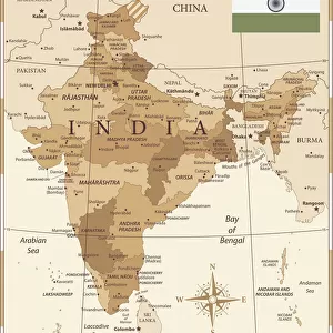
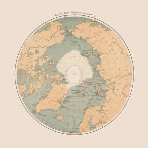
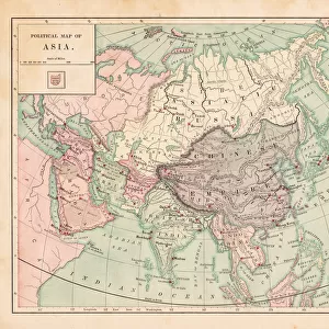
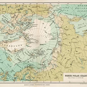
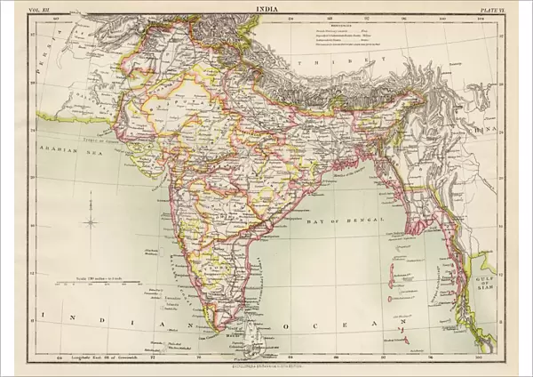
India map 1881
Encyclopedia Britannica 9th Edition Vol XII Philadelphia j.M. Stoddart & Co 1881
Unleash your creativity and transform your space into a visual masterpiece!
THEPALMER
Media ID 13611521
© This content is subject to copyright
India Pakistan Paper World Map
A2 (42x59cm) Fine Art Print
Discover the rich history and cultural heritage of India with this stunning Fine Art Print from Media Storehouse. Featuring the India map from the Encyclopedia Britannica 9th Edition, published by J.M. Stoddart & Co in Philadelphia in 1881, this print is a captivating representation of India during that era. The intricate details and vibrant colors bring the map to life, making it a beautiful addition to any home or office. This Fine Art Print, titled "India Map 1881 by THEPALMER," is a must-have for history enthusiasts, geography buffs, and anyone who appreciates the beauty of historical cartography.
Our Fine Art Prints are printed on 100% acid free, PH neutral paper with archival properties. This printing method is used by museums and art collections to exhibit photographs and art reproductions. Hahnemühle certified studio for digital fine art printing. Printed on 308gsm Photo Rag Paper.
Our fine art prints are high-quality prints made using a paper called Photo Rag. This 100% cotton rag fibre paper is known for its exceptional image sharpness, rich colors, and high level of detail, making it a popular choice for professional photographers and artists. Photo rag paper is our clear recommendation for a fine art paper print. If you can afford to spend more on a higher quality paper, then Photo Rag is our clear recommendation for a fine art paper print.
Estimated Image Size (if not cropped) is 56.3cm x 42cm (22.2" x 16.5")
Estimated Product Size is 59.4cm x 42cm (23.4" x 16.5")
These are individually made so all sizes are approximate
Artwork printed orientated as per the preview above, with landscape (horizontal) orientation to match the source image.
FEATURES IN THESE COLLECTIONS
> Asia
> India
> Related Images
> Asia
> Pakistan
> Related Images
> Maps and Charts
> India
> Maps and Charts
> Related Images
> Maps and Charts
> World
> North America
> United States of America
> Maps
> Fine Art Storehouse
> The Magical World of Illustration
> Palmer Illustrated Collection
> Fine Art Storehouse
> Map
> Historical Maps
EDITORS COMMENTS
This print takes us back in time to the year 1881, showcasing an exquisite illustration of the India map. Derived from the renowned Encyclopedia Britannica's 9th Edition Volume XII, Philadelphia-based publishers J. M. Stoddart & Co meticulously crafted this piece of cartographic artistry. The print captures a horizontal view of the map, displaying not only India but also neighboring countries such as Pakistan and even stretching across continents to include parts of the United States. Printed on high-quality paper, this antique gem showcases intricate details that transport us into a world where physical geography was explored through engravings and illustrations. Every contour and boundary is delicately etched onto the surface, revealing a meticulous craftsmanship that has stood the test of time. As we gaze upon this vintage masterpiece, we are reminded of how maps have long been cherished tools for exploration and understanding our place in the world. This particular rendition offers a glimpse into an era when cartography was both scientific endeavor and artistic expression. The Palmer's skillful capture allows us to appreciate every nuance present in this historical artifact while preserving its essence for generations to come. Whether you're an avid collector or simply captivated by history's allure, this print serves as a timeless reminder of our ever-evolving understanding of our planet's diverse landscapes
MADE IN THE UK
Safe Shipping with 30 Day Money Back Guarantee
FREE PERSONALISATION*
We are proud to offer a range of customisation features including Personalised Captions, Color Filters and Picture Zoom Tools
SECURE PAYMENTS
We happily accept a wide range of payment options so you can pay for the things you need in the way that is most convenient for you
* Options may vary by product and licensing agreement. Zoomed Pictures can be adjusted in the Basket.