Framed Print > Africa > Zimbabwe > Rhodesia
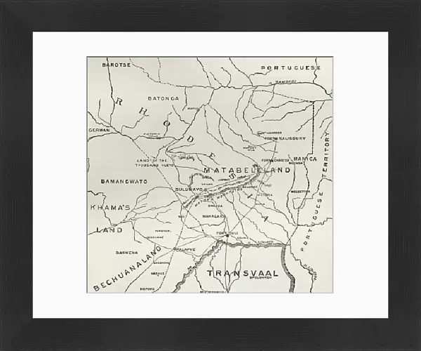
Framed Print : Map of Matabeleland in the late 19th century, from South Africa and the Transvaal War: Vol. 1 by Louis Creswicke, published 1900 (litho)
")
")


![]()
Framed Photos from Fine Art Finder
Map of Matabeleland in the late 19th century, from South Africa and the Transvaal War: Vol. 1 by Louis Creswicke, published 1900 (litho)
KW371011 Map of Matabeleland in the late 19th century, from South Africa and the Transvaal War: Vol. 1 by Louis Creswicke, published 1900 (litho) by English School, (20th century); Private Collection
Media ID 32180954
© Bridgeman Images
30"x26" (78x68cm) Modern Frame
Step back in time with our exquisite Framed Print of a historic Map of Matabeleland from the late 19th century. This beautifully preserved antique map, taken from "South Africa and the Transvaal War: Vol. 1" by Louis Creswicke, published in 1900, offers a fascinating glimpse into the past. The intricate lithographic detail brings to life the geography and political landscape of the region during a pivotal period in African history. This rare and captivating piece, copyrighted by Ken Welsh from Fine Art Finder, adds an air of sophistication and historical intrigue to any room. Own a piece of history with our Framed Print of the Map of Matabeleland.
Wood effect frame, card mounted, 24x20 archival quality photo print. Overall outside dimensions 30x26 inches (76x68cm). Environmentally and ozone friendly, 43mm wide x 32mm Polycore® moulding has the look of real wood, is durable and light and easy to hang. Biodegradable and made with non-chlorinated gases (no toxic fumes) it is efficient; producing 100 tons of polystyrene can save 300 tons of trees! Prints are glazed with lightweight, shatterproof, optical clarity acrylic (providing the same general protection from the environment as glass). The back is stapled hardboard with a sawtooth hanger attached. Note: To minimise original artwork cropping, for optimum layout, and to ensure print is secure, the visible print may be marginally smaller
Contemporary Framed and Mounted Prints - Professionally Made and Ready to Hang
Estimated Image Size (if not cropped) is 59.9cm x 59.4cm (23.6" x 23.4")
Estimated Product Size is 78.2cm x 68.2cm (30.8" x 26.9")
These are individually made so all sizes are approximate
Artwork printed orientated as per the preview above, with landscape (horizontal) orientation to match the source image.
FEATURES IN THESE COLLECTIONS
> Fine Art Finder
> Artists
> English School
> Fine Art Finder
> Maps (celestial & Terrestrial)
> Africa
> South Africa
> Maps
> Africa
> South Africa
> Related Images
> Africa
> Zimbabwe
> Rhodesia
> Maps and Charts
> Related Images
EDITORS COMMENTS
This lithograph print showcases a historical treasure, the "Map of Matabeleland in the late 19th century". Created by an anonymous English School artist in the early 20th century, this map was originally published in Louis Creswicke's renowned book "South Africa and the Transvaal War: Vol. 1" in 1900. The intricate details depicted on this map offer a fascinating glimpse into the territorial landscape of Matabeleland during that era. Every contour and boundary is meticulously engraved, allowing viewers to explore and understand the region's geography with precision. Matabeleland, located within Rhodesia (now Zimbabwe), holds significant historical importance due to its involvement in various conflicts and colonization efforts. This map serves as a valuable resource for historians, cartographers, and enthusiasts alike who seek to study or trace the evolution of this region over time. Preserved within a private collection, this lithograph print not only captures an important piece of history but also highlights the skillful craftsmanship involved in creating such detailed maps. Its artistic value lies not only in its accuracy but also in its ability to transport us back to a pivotal period when exploration and mapping played crucial roles in shaping our understanding of different territories around the world. With Ken Welsh's copyright stamp ensuring authenticity, this remarkable artwork stands as both an educational tool and a testament to human curiosity about our surroundings throughout history.
MADE IN THE UK
Safe Shipping with 30 Day Money Back Guarantee
FREE PERSONALISATION*
We are proud to offer a range of customisation features including Personalised Captions, Color Filters and Picture Zoom Tools
SECURE PAYMENTS
We happily accept a wide range of payment options so you can pay for the things you need in the way that is most convenient for you
* Options may vary by product and licensing agreement. Zoomed Pictures can be adjusted in the Basket.