Home > North America > United States of America > Texas > Houston
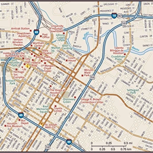
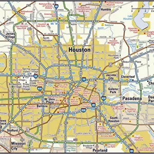
Houston Texas US City Street Map

![]()
Wall Art and Photo Gifts from Fine Art Storehouse
Houston Texas US City Street Map
Vector Illustration of a City Street Map of Houston, Texas, USA. Scale 1:60, 000.
All source data is in the public domain.
U.S. Geological Survey, US Topo
Used Layers:
USGS The National Map: National Hydrography Dataset (NHD)
USGS The National Map: National Transportation Dataset (NTD)
Unleash your creativity and transform your space into a visual masterpiece!
Frank Ramspott
Media ID 15215776
© Frank Ramspott, all rights reserved
Aerial View City Map Computer Graphic Directly Above Downtown District Gray Road Map Texas Text Digitally Generated Image Green Color Houston White Color
FEATURES IN THESE COLLECTIONS
> Aerial Photography
> Related Images
> Animals
> Insects
> Hemiptera
> Green Scale
> Arts
> Landscape paintings
> Waterfall and river artworks
> River artworks
> Arts
> Portraits
> Pop art gallery
> Street art portraits
> Fine Art Storehouse
> Map
> Street Maps
> Fine Art Storehouse
> Map
> USA Maps
> Maps and Charts
> Geological Map
> North America
> United States of America
> Lakes
> Related Images
> North America
> United States of America
> Maps
> North America
> United States of America
> Texas
> Houston
EDITORS COMMENTS
This print showcases a meticulously detailed city street map of Houston, Texas, USA. With a scale of 1:60,000, the vector illustration provides an accurate representation of the city's layout and infrastructure. The artist, Frank Ramspott, skillfully utilized various layers from publicly available data sources such as USGS The National Map: National Hydrography Dataset (NHD) and USGS The National Map: National Transportation Dataset (NTD). The image captures the essence of Houston's downtown district with its bustling streets and vibrant energy. A prominent lake and river add to the natural beauty that surrounds this urban landscape. From roads to buildings, every element is intricately designed in this digitally generated artwork. Rendered in shades of gray, blue, white, and green colors against a backdrop of textural details, this visually stunning aerial view offers a unique perspective on Houston's physical geography. Free from any human presence or commercial references mentioned by the artist himself – not associated with any company – it allows viewers to focus solely on appreciating the artistry behind this cartographic masterpiece. Ideal for enthusiasts of maps or those seeking an artistic representation of their favorite cityscape, this print is sure to captivate anyone who lays eyes upon it.
MADE IN THE UK
Safe Shipping with 30 Day Money Back Guarantee
FREE PERSONALISATION*
We are proud to offer a range of customisation features including Personalised Captions, Color Filters and Picture Zoom Tools
SECURE PAYMENTS
We happily accept a wide range of payment options so you can pay for the things you need in the way that is most convenient for you
* Options may vary by product and licensing agreement. Zoomed Pictures can be adjusted in the Basket.