Home > Africa > Benin > Maps
Photo Mug : Map of Nigeria


![]()
Home Decor from Fine Art Storehouse
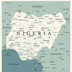
Map of Nigeria
Nigeria is a country on the coast of West Africa, bordered in south by the Bight of Benin and the Bight of Biafra (Bight of Bonny), both part of the Gulf of Guinea, by Niger in north, Benin in west, Cameroon in south east, and by Chad in north east by a boundary across Lake Chad. The nation shares maritime borders with Equatorial Guinea, Ghana, and S├úo Tom├® and Pr├¡ncipe
Unleash your creativity and transform your space into a visual masterpiece!
Media ID 20251041
Photo Mug
Introducing the Media Storehouse Photo Mug featuring a stunning image of a Map of Nigeria from our Fine Art Storehouse collection. This high-quality mug is not just a beverage holder, it's a way to showcase your love for the diverse and beautiful country of Nigeria. The vibrant, detailed map design is sure to grab attention and spark interesting conversations. Each mug is made with premium ceramic material, making it durable, microwave and dishwasher safe for your convenience. Order yours today and enjoy your favorite drink while celebrating the beauty of Nigeria's rich cultural heritage.
A personalised photo mug blends sentimentality with functionality, making an ideal gift for cherished loved ones, close friends, or valued colleagues. Preview may show both sides of the same mug.
Elevate your coffee or tea experience with our premium white ceramic mug. Its wide, comfortable handle makes drinking easy, and you can rely on it to be both microwave and dishwasher safe. Sold in single units, preview may show both sides of the same mug so you can see how the picture wraps around.
Mug Size is 9.5cm high x 8cm diameter (3.7" x 3.1")
These are individually made so all sizes are approximate
FEATURES IN THESE COLLECTIONS
> Africa
> Benin
> Related Images
> Africa
> Cameroon
> Lakes
> Related Images
> Africa
> Cameroon
> Related Images
> Africa
> Chad
> Lakes
> Lake Chad
> Africa
> Chad
> Lakes
> Related Images
> Africa
> Chad
> Related Images
> Africa
> Equatorial Guinea
> Maps
> Africa
> Equatorial Guinea
> Related Images
EDITORS COMMENTS
This stunning print showcases the intricate and diverse geography of Nigeria, a vibrant country located on the coast of West Africa. The map beautifully depicts Nigeria's borders, with the Bight of Benin and the Bight of Biafra (Bight of Bonny) gracing its southern coastline as part of the Gulf of Guinea. To the north lies Niger, while Benin rests to its west. In the southeast, Cameroon shares a border with Nigeria, and in the northeast, Chad is separated by a boundary that stretches across Lake Chad. Nigeria's rich cultural heritage and natural beauty are perfectly encapsulated in this image. As one gazes upon it, they can almost feel themselves immersed in Nigeria's bustling cities, picturesque landscapes, and vibrant communities. This print not only serves as an educational tool but also evokes a sense of wanderlust for those who have yet to explore this remarkable nation. With maritime borders shared with Equatorial Guinea, Ghana, S├úo Tom├® and Pr├¡ncipe islands further enhance Nigeria's connection to neighboring countries within Africa. Whether displayed in classrooms or homes around the world, this print is sure to spark curiosity about Nigeria's history and allure visitors towards discovering its hidden treasures firsthand.
MADE IN THE UK
Safe Shipping with 30 Day Money Back Guarantee
FREE PERSONALISATION*
We are proud to offer a range of customisation features including Personalised Captions, Color Filters and Picture Zoom Tools
SECURE PAYMENTS
We happily accept a wide range of payment options so you can pay for the things you need in the way that is most convenient for you
* Options may vary by product and licensing agreement. Zoomed Pictures can be adjusted in the Basket.