Home > North America > United States of America > New York > New York > Maps
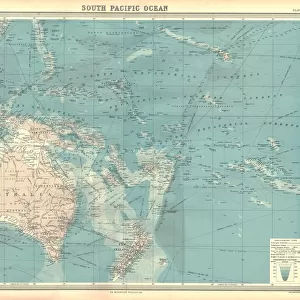
New Gunia Papua map 1884

![]()
Wall Art and Photo Gifts from Fine Art Storehouse
New Gunia Papua map 1884
Encyclopedia Britannica 9th Edition New York Charles Scribners and Sonsl 1884 Vol XVII
Unleash your creativity and transform your space into a visual masterpiece!
THEPALMER
Media ID 14756818
© This content is subject to copyright
FEATURES IN THESE COLLECTIONS
> Fine Art Storehouse
> Map
> Historical Maps
> Maps and Charts
> Early Maps
> North America
> United States of America
> New York
> New York
> Maps
> Oceania
> Papua New Guinea
> Maps
EDITORS COMMENTS
In this print titled "New Gunia Papua map 1884" we are transported back in time to the late 19th century, where exploration and cartography were at their peak. This extraordinary piece, sourced from the Encyclopedia Britannica's 9th Edition published by Charles Scribners and Sons in New York, takes us on a visual journey through the uncharted lands of Caledonia, New Guinea, and Papua. The intricate details of this vintage map serve as a testament to the meticulous craftsmanship of its creator. Every contour line and geographic feature has been delicately etched onto paper with utmost precision. As we examine it closely, we can almost feel the excitement that must have filled those early explorers' hearts as they ventured into unknown territories. Through THEPALMER's expert lens, this historical artifact is transformed into a work of art that not only showcases geographical accuracy but also evokes a sense of wonderment. The faded hues and aged texture lend an air of nostalgia to the print, reminding us of our connection to past generations who sought knowledge through maps like these. This remarkable photograph invites us to reflect upon how far our understanding of these regions has come since 1884 while simultaneously appreciating the beauty inherent in antique cartography. It serves as a reminder that even in today's digital age, there is still something truly enchanting about holding a physical representation of history in our hands.
MADE IN THE UK
Safe Shipping with 30 Day Money Back Guarantee
FREE PERSONALISATION*
We are proud to offer a range of customisation features including Personalised Captions, Color Filters and Picture Zoom Tools
SECURE PAYMENTS
We happily accept a wide range of payment options so you can pay for the things you need in the way that is most convenient for you
* Options may vary by product and licensing agreement. Zoomed Pictures can be adjusted in the Basket.