Home > Animals > Insects > Hemiptera > Green Scale
Vallejo California US City Street Map

![]()
Wall Art and Photo Gifts from Fine Art Storehouse
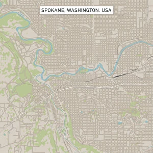
Vallejo California US City Street Map
Vector Illustration of a City Street Map of Vallejo, California, USA. Scale 1:60, 000.
All source data is in the public domain.
U.S. Geological Survey, US Topo
Used Layers:
USGS The National Map: National Hydrography Dataset (NHD)
USGS The National Map: National Transportation Dataset (NTD)
Unleash your creativity and transform your space into a visual masterpiece!
Frank Ramspott
Media ID 15055067
© Frank Ramspott, all rights reserved
Aerial View California City Map Computer Graphic Directly Above Downtown District Gray Road Map Text Digitally Generated Image Green Color Vallejo White Color
FEATURES IN THESE COLLECTIONS
> Aerial Photography
> Related Images
> Animals
> Insects
> Hemiptera
> Green Scale
> Arts
> Landscape paintings
> Waterfall and river artworks
> River artworks
> Arts
> Portraits
> Pop art gallery
> Street art portraits
> Fine Art Storehouse
> Map
> Street Maps
> Fine Art Storehouse
> Map
> USA Maps
> Maps and Charts
> Geological Map
> North America
> United States of America
> California
> Related Images
> North America
> United States of America
> Lakes
> Related Images
> North America
> United States of America
> Maps
EDITORS COMMENTS
This print showcases a meticulously detailed city street map of Vallejo, California, USA. With a scale of 1:60,000, every intricate feature is beautifully illustrated in this vector image. The source data used for creating this masterpiece is in the public domain and comes from the U. S. Geological Survey's National Hydrography Dataset (NHD) and National Transportation Dataset (NTD), ensuring accuracy and reliability. The artwork highlights various significant landmarks such as Mare Island Strait, San Pablo Bay, downtown district, river, lake, streets, and roads that form the backbone of this vibrant city. The expertly crafted cartography design brings out the essence of Vallejo's urban landscape. Rendered using computer graphics technology with no people present in the scene allows viewers to focus solely on exploring the intricacies of this visually stunning piece. The color palette features shades of gray representing roadways and buildings while green symbolizes natural elements like parks or open spaces. Blue hues depict water bodies such as rivers and lakes while white adds contrast to highlight essential details. This aerial view from directly above provides a unique perspective on Vallejo's physical geography—combining artistry with functionality to create an engaging visual representation suitable for any space or decor style. This digitally generated image by Frank Ramspott captures the essence of Vallejo's urban charm through its meticulous attention to detail and artistic flair.
MADE IN THE UK
Safe Shipping with 30 Day Money Back Guarantee
FREE PERSONALISATION*
We are proud to offer a range of customisation features including Personalised Captions, Color Filters and Picture Zoom Tools
SECURE PAYMENTS
We happily accept a wide range of payment options so you can pay for the things you need in the way that is most convenient for you
* Options may vary by product and licensing agreement. Zoomed Pictures can be adjusted in the Basket.