Home > Europe > United Kingdom > England > Norfolk > Hingham
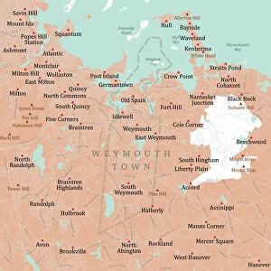
MA Norfolk Quincy Vector Road Map

![]()
Wall Art and Photo Gifts from Fine Art Storehouse
MA Norfolk Quincy Vector Road Map
MA Norfolk Quincy Vector Road Map. All source data is in the public domain. U.S. Census Bureau Census Tiger. Used Layers: areawater, linearwater, roads, rails, cousub, pointlm, uac10
Unleash your creativity and transform your space into a visual masterpiece!
Frank Ramspott
Media ID 20692425
© Frank Ramspott, all rights reserved
City Map Computer Graphic County Digital Composite District Geographical Border Harbor Massachusetts Norfolk Road Map Text Vector Boston Harbor Digitally Generated Image Milton Quincy Wollaston
FEATURES IN THESE COLLECTIONS
> Animals
> Birds
> Gruiformes
> Rallidae
> Water Rail
> Animals
> Mammals
> Cats (Wild)
> Tiger
> Arts
> Landscape paintings
> Waterfall and river artworks
> River artworks
> Arts
> Portraits
> Pop art gallery
> Street art portraits
> Arts
> Street art graffiti
> Digital art
> Digital paintings
> Europe
> United Kingdom
> England
> Norfolk
> Hingham
> Fine Art Storehouse
> Map
> Reference Maps
> Maps and Charts
> Related Images
> North America
> United States of America
> Massachusetts
> Boston
EDITORS COMMENTS
This vibrant and detailed print captures the essence of MA Norfolk Quincy Vector Road Map. Created by Frank Ramspott, this digitally generated image showcases the intricate design and cartography skills involved in producing a visually stunning map. The use of vector technology ensures sharpness and clarity, allowing viewers to explore every nook and cranny of Massachusetts' Norfolk County. The map incorporates various layers, including areawater, linearwater, roads, rails, cousub, pointlm, and uac10 data sourced from the U. S. Census Bureau Census Tiger database – all available in the public domain. With its colorful palette and precise detailing, this print is a testament to both physical geography and computer graphics. While devoid of people or any human presence, this image speaks volumes about the geographical borders that shape our cities. From rivers like Wollaston to lakes such as Merrymount; from Squantum's coastline to Hingham Bay's tranquil waters; from Nantasket Roads to Boston Harbor – each element is meticulously represented on this map. Whether you're an avid traveler seeking navigational guidance or simply appreciate fine art with a touch of educational value, this print offers it all. It invites you to embark on a visual journey through Quincy's streets while admiring its bay views and harbor charm
MADE IN THE UK
Safe Shipping with 30 Day Money Back Guarantee
FREE PERSONALISATION*
We are proud to offer a range of customisation features including Personalised Captions, Color Filters and Picture Zoom Tools
SECURE PAYMENTS
We happily accept a wide range of payment options so you can pay for the things you need in the way that is most convenient for you
* Options may vary by product and licensing agreement. Zoomed Pictures can be adjusted in the Basket.