Fraud Blocker Skip to main content

Home > North America > United States of America > Ohio > Cincinnati

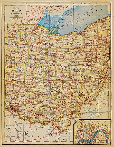
1883 Ohio State Map

1883 Ohio State Map
Sold 1
In Stock
We accept all major payment options so you can pay for the things you need in the way that is most convenient for you

Choose Your Product

Framed Photos
Buy from £59.99
Photo Prints
Buy from £6.99
Jigsaw Puzzles
Buy from £32.99
Poster Prints
Buy from £16.99
Canvas Prints
Buy from £34.99
Fine Art Prints
Buy from £49.99
Mounted Prints
Buy from £17.99
Metal Prints
Buy from £79.99
Cards
Buy from £8.97
Home Decor
Buy from £14.99

Fine Art Storehouse Photo Prints and Wall Art

1883 Ohio State Map

1883 Ohio State Map. Unleash your creativity and transform your space into a visual masterpiece. © benoitb

benoitb

Media ID 15245281

Cincinnati Kentucky Lake Erie Michigan Ohio Retro Revival Road Map State Us State Border West Virginia Ohio State

FEATURES IN THESE COLLECTIONS

> Fine Art Storehouse > Map > Map Illustrations

> North America > United States of America > Ohio > Cincinnati

SECURE PAYMENTS
We accept all major payment options so you can pay for the things you need in the way that is most convenient for you

Made in UK
Safe Shipping, Easy Returns

FREE PERSONALISATION
We are proud to offer a range of customisation including Cropping, Captions, and Filters. Zoom Cropping can be adjusted in the basket


EDITORS COMMENTS

This print showcases the intricate details of an 1883 Ohio State Map, taking us back in time to a bygone era. The artistry and craftsmanship evident in this cartographic masterpiece are truly remarkable. Every contour, river, and city is meticulously depicted, offering a glimpse into the state's rich history. The retro revival aesthetic adds an extra layer of charm to this piece. It evokes nostalgia for a simpler time when maps were carefully crafted by hand rather than generated digitally. This vintage appeal makes it a perfect addition to any home or office space seeking to capture the essence of yesteryears. One cannot help but be drawn towards Lake Erie on this map, its vastness stretching across the northern border of Ohio. From Cincinnati in the southwest corner to West Virginia in the southeast, every region is intricately illustrated with precision and accuracy. The neighboring states of Michigan and Kentucky also find their place within these borders. Benoitb's expertise shines through as he captures not only geographical accuracy but also manages to convey a sense of wonderment that comes from exploring one's own state through such detailed cartography. Whether you're an avid historian or simply appreciate fine art, this 1883 Ohio State Map print will transport you back in time while adding character and sophistication to your surroundings.


Framed Prints of 1883 Ohio State Map

Discover the rich history of Ohio with our stunning 1883 Ohio State Map Framed Print from Benoitb at Media Storehouse. This vintage map transports you back in time, capturing the essence of the Buckeye State during its formative years. The intricate details of the map are beautifully preserved, making it a unique and captivating addition to any room. The high-quality framed print is carefully crafted with a protective glass cover and sturdy frame, ensuring long-lasting durability. Bring a touch of history and charm to your home or office décor with this beautiful piece from our Fine Art Storehouse collection.


Photo Prints of 1883 Ohio State Map

Step back in time with our exquisite 1883 Ohio State Map print from Benoitb's Fine Art Storehouse collection. This vintage map offers a captivating glimpse into the history of the Buckeye State, with intricate details revealing the political boundaries, major cities, and towns of the time. Perfect for history enthusiasts, educators, or anyone with an appreciation for the past, this photographic print makes a stunning addition to any home or office decor. Bring the past to life with this unique and intriguing piece.


Poster Prints of 1883 Ohio State Map

"Step back in time with our exquisite 1883 Ohio State Map print from Benoitb's Fine Art Storehouse collection. This captivating poster transport you to a bygone era, showcasing intricate details of Ohio's geography and political boundaries as they existed over a century ago. Ideal for history enthusiasts, educators, or those who appreciate the charm of vintage maps, this print makes a striking addition to any room. Bring a piece of historical accuracy and intrigue into your home or office decor."


Jigsaw Puzzles of 1883 Ohio State Map

Discover the historical charm of yesteryears with our 1883 Ohio State Map jigsaw puzzle from Benoitb's Fine Art Storehouse collection. This intricately detailed puzzle features an antique map of Ohio from 1883, offering a captivating journey back in time. Perfect for puzzle enthusiasts and history buffs, this jigsaw puzzle promises hours of engaging entertainment as you piece together the vibrant and intricate design. Bring a piece of the past into your home and create a beautiful display once completed.

diamond
Made With High Grade Materials
thumb_up
Professional Quality Finish
package_2
Carefully Packed To Aid Safe Arrival

You May Also Like


Ohio MapOhio Map
Add to Basket
Ohio 1852 MapOhio 1852 Map
Add to Basket
City skyline and the Scioto River, Columbus, Ohio, United States of AmericaCity skyline and the Scioto River, Columbus, Ohio, United States of America
Add to Basket
Crosley Field sports ground, Cincinnati, Ohio, USACrosley Field sports ground, Cincinnati, Ohio, USA
Add to Basket
CINCINNATI: HOUSES, 1935. A row of low-income houses with outhouses facing railroad tracks, Cincinnati, Ohio. Photograph by Carl Mydans in December 1935CINCINNATI: HOUSES, 1935. A row of low-income houses with outhouses facing railroad tracks, Cincinnati, Ohio. Photograph by Carl Mydans in December 1935
Add to Basket
Cincinnati, Ohio, 1870sCincinnati, Ohio, 1870s
Add to Basket
Downtown Cleveland, OhioDowntown Cleveland, Ohio
Add to Basket
Ohio road mapOhio road map
Add to Basket
North Central states map 1886North Central states map 1886
Add to Basket
Spring BlossomsSpring Blossoms
Add to Basket
Romy Schneider March 1968 Actress with sonRomy Schneider March 1968 Actress with son
Add to Basket
World map from 1520World map from 1520
Add to Basket

Gallery Wall Inspiration

Italy Map - illustration
East Asia Map
Map of Switzerland
Map of South East England, Hampshire, Dorset, Wiltshire 1891
USA Map - illustration
Canada Map - illustration
28 - Poland - Color2 10
Map of Sweden - Vector
Map of Ireland
Ireland Vector Map
Africa Map
World map from 1520
27 - Denmark - Color1 10
Map of Belgium - Vector
25 - India - Vintage Golden 10
Asia Map - illustration
Georgia State Vector Map
1883 Ohio State Map
24 - Poland - Vintage Murena Isolated 10
24 - India - Vintage Murena Isolated 10
Africa Infographic map
Eurasia - Infographic map - illustration
Scotland Vector Map
Florida Vector Map
Japan Vector Map
Turkey Vector Map
Ukraine Vector Map


© Copyright Media Storehouse, All Rights Reserved 2003 - 2024
Facebook     Pinterest     100% Payment Secure     Reviews IO