Home > North America > United States of America > New York > New York > Maps
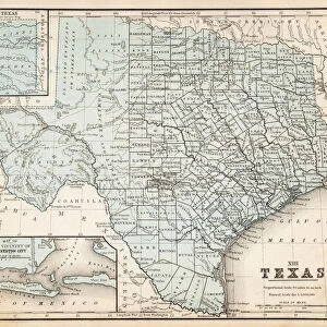
Texas map 1881

![]()
Wall Art and Photo Gifts from Fine Art Storehouse
Texas map 1881
Coltons Common School Geography 1881 New York Sheldon and Co
Unleash your creativity and transform your space into a visual masterpiece!
THEPALMER
Media ID 13669267
© This content is subject to copyright
American Culture Globe Navigational Equipment Gulf Coast States North America Paper Planet Earth Texas World Map
FEATURES IN THESE COLLECTIONS
> Fine Art Storehouse
> The Magical World of Illustration
> Palmer Illustrated Collection
> Fine Art Storehouse
> Map
> Historical Maps
> Fine Art Storehouse
> Map
> USA Maps
> Maps and Charts
> Related Images
> Maps and Charts
> World
> North America
> Related Images
> North America
> United States of America
> Maps
> North America
> United States of America
> New York
> New York
> Maps
> North America
> United States of America
> New York
> Related Images
> North America
> United States of America
> Texas
> Related Images
> Science
> Space Exploration
> Planets
> Earth
EDITORS COMMENTS
In this print titled "Texas map 1881" we are transported back in time to the late 19th century, when cartography was a meticulous art form. The image showcases an exquisite engraving from Colton's Common School Geography of 1881, published by Sheldon and Co in New York. This vintage piece offers us a glimpse into the past, revealing the intricate details of Texas' geography as it existed over a century ago. The map itself is beautifully crafted, showcasing not only Texas but also its surrounding Gulf Coast states within North America. Its vertical orientation allows us to appreciate the vastness and diversity of this great state. As we examine closer, we can see how early navigational equipment like globes were incorporated into the design, emphasizing both exploration and education. This antique illustration transports us to an era where paper maps were essential tools for understanding our world. It serves as a reminder of American culture's deep-rooted connection with physical geography and exploration. "The Texas map 1881" by THEPALMER takes us on a journey through time while celebrating the artistry behind old-world cartography. It invites viewers to reflect on how our perception of planet Earth has evolved throughout history while appreciating the beauty found within engraved images such as this one.
MADE IN THE UK
Safe Shipping with 30 Day Money Back Guarantee
FREE PERSONALISATION*
We are proud to offer a range of customisation features including Personalised Captions, Color Filters and Picture Zoom Tools
SECURE PAYMENTS
We happily accept a wide range of payment options so you can pay for the things you need in the way that is most convenient for you
* Options may vary by product and licensing agreement. Zoomed Pictures can be adjusted in the Basket.