Fine Art Print > Universal Images Group (UIG) > Universal Images Group > Satellite and Aerial > Planet Observer 5
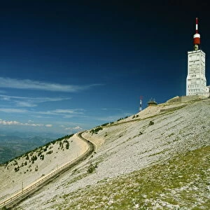
Fine Art Print : Departement of Ariege, France, Satellite Image With Bump Effect


![]()
Fine Art Prints from Universal Images Group (UIG)
Departement of Ariege, France, Satellite Image With Bump Effect
Satellite view with bump effect of the departement of Ariege, France. It is dominated by the Pyrenees mountains which form the border between France and Spain. This image was compiled from data acquired by LANDSAT 5 & 7 satellites combined with elevation data
Universal Images Group (UIG) manages distribution for many leading specialist agencies worldwide
Media ID 9633895
© Planet Observer
Ariege Geographical Border Midi Pyrenees Mountain Pyrenees Foix Satellite View
A2 (42x59cm) Fine Art Print
Discover the breathtaking beauty of the French departement of Ariege with this stunning Fine Art Print from Media Storehouse. Featuring a satellite image from Universal Images Group with an added bump effect, this unique perspective showcases the majestic Pyrenees mountains that gracefully border France and Spain. Bring the awe-inspiring landscape into your home or office and elevate your decor with this captivating piece of art.
Our Fine Art Prints are printed on 100% acid free, PH neutral paper with archival properties. This printing method is used by museums and art collections to exhibit photographs and art reproductions. Hahnemühle certified studio for digital fine art printing. Printed on 308gsm Photo Rag Paper.
Our fine art prints are high-quality prints made using a paper called Photo Rag. This 100% cotton rag fibre paper is known for its exceptional image sharpness, rich colors, and high level of detail, making it a popular choice for professional photographers and artists. Photo rag paper is our clear recommendation for a fine art paper print. If you can afford to spend more on a higher quality paper, then Photo Rag is our clear recommendation for a fine art paper print.
Estimated Product Size is 59.4cm x 42cm (23.4" x 16.5")
These are individually made so all sizes are approximate
Artwork printed orientated as per the preview above, with landscape (horizontal) orientation to match the source image.
EDITORS COMMENTS
This print showcases the stunning beauty of the Departement of Ariege in France, with a unique bump effect that adds depth and texture to the satellite view. The dominant feature of this region is undoubtedly the majestic Pyrenees mountains, which proudly stand as a natural border between France and Spain. Compiled from data acquired by LANDSAT 5 & 7 satellites combined with elevation data, this image offers an extraordinary glimpse into the topography and physical geography of Ariege. Every contour and peak is meticulously captured, allowing us to appreciate the intricate details of this mountainous landscape. As we explore this photograph, our eyes are drawn to Foix – a charming town nestled amidst these awe-inspiring peaks. The vibrant colors bring life to every element within the frame, making it feel like we are witnessing nature's masterpiece firsthand. With no people present in this shot, we can fully immerse ourselves in its tranquility and grandeur. This horizontal composition invites us to embark on a visual journey through Europe's enchanting outdoors. Whether you're an avid cartographer or simply someone who appreciates breathtaking scenery, this print serves as both an artistic marvel and a valuable geographical reference. It encapsulates not only the geographical border but also captures the essence of Ariege's rugged charm.
MADE IN THE UK
Safe Shipping with 30 Day Money Back Guarantee
FREE PERSONALISATION*
We are proud to offer a range of customisation features including Personalised Captions, Color Filters and Picture Zoom Tools
SECURE PAYMENTS
We happily accept a wide range of payment options so you can pay for the things you need in the way that is most convenient for you
* Options may vary by product and licensing agreement. Zoomed Pictures can be adjusted in the Basket.