Fine Art Print > Europe > United Kingdom > England > Yorkshire > Wakefield
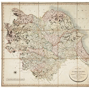
Fine Art Print : New map of Yorkshire divided into its Ridings, surveyed 1815-1817


![]()
Fine Art Prints from Sheffield City Archives
New map of Yorkshire divided into its Ridings, surveyed 1815-1817
By Christopher Greenwood.Made on the basis of triangles in the County, determined by Lieut. Col. Wm. Mudge... and Captn. Thos. Colby... in the trigonometrical survey of England by order of the Honourable Board of Ordnance and surveyed in the years 1815, 1816, and 1817.Engraved by S. Neele and Son, London; published by Robinson, Son and Holdsworth, Leeds, John Hurst and C. Greenwood, Wakefield, 4 June 1817.Original at Sheffield City Archives: SY109/Z1/1
Sheffield City Archives and Local Studies Library has an unrivalled collection of images of Sheffield, England
Media ID 14046224
© Sheffield City Council
A2 (42x59cm) Fine Art Print
Discover the rich history of Yorkshire with our exquisite Fine Art Print of the 1815-1817 New Map of Yorkshire, meticulously surveyed by Lieut. Col. Wm. Mudge and Captn. Thos. Colby from the Sheffield City Archives. This stunning piece, created by renowned artist Christopher Greenwood, showcases the county's historical divisions into Ridings. Add an air of sophistication and local pride to your home or office with this beautiful and intricately detailed work of art. A perfect addition to any collection, this print is a must-have for those with a love for history and the Yorkshire region.
Our Fine Art Prints are printed on 100% acid free, PH neutral paper with archival properties. This printing method is used by museums and art collections to exhibit photographs and art reproductions. Hahnemühle certified studio for digital fine art printing. Printed on 308gsm Photo Rag Paper.
Our fine art prints are high-quality prints made using a paper called Photo Rag. This 100% cotton rag fibre paper is known for its exceptional image sharpness, rich colors, and high level of detail, making it a popular choice for professional photographers and artists. Photo rag paper is our clear recommendation for a fine art paper print. If you can afford to spend more on a higher quality paper, then Photo Rag is our clear recommendation for a fine art paper print.
Estimated Image Size (if not cropped) is 46.6cm x 42cm (18.3" x 16.5")
Estimated Product Size is 59.4cm x 42cm (23.4" x 16.5")
These are individually made so all sizes are approximate
Artwork printed orientated as per the preview above, with landscape (horizontal) orientation to match the source image.
FEATURES IN THESE COLLECTIONS
> Arts
> Artists
> G
> John Greenwood
> Arts
> Artists
> J
> John June
> Europe
> United Kingdom
> England
> Leeds
> Europe
> United Kingdom
> England
> Maps
> Europe
> United Kingdom
> England
> Sheffield
> Europe
> United Kingdom
> England
> Wakefield
> Europe
> United Kingdom
> England
> Yorkshire
> Leeds
> Europe
> United Kingdom
> England
> Yorkshire
> Related Images
> Europe
> United Kingdom
> England
> Yorkshire
> Sheffield
> Europe
> United Kingdom
> England
> Yorkshire
> Wakefield
> Sheffield City Archives
> Maps and Plans
EDITORS COMMENTS
This print showcases the "New map of Yorkshire divided into its Ridings, surveyed 1815-1817" with meticulous precision and historical significance. Created by Christopher Greenwood, this masterpiece was crafted using triangles in the County as determined by Lieut. Col. Wm. Mudge and Captn. Thos. Colby during their trigonometrical survey of England under the orders of the Honourable Board of Ordnance. Engraved by S. Neele and Son in London, this remarkable piece was published on 4 June 1817 by Robinson, Son and Holdsworth in Leeds, John Hurst in Wakefield, and C. Greenwood himself. The attention to detail is evident as every nook and cranny of Yorkshire's landscape is meticulously captured. As a testament to its historical value, this original map can be found at Sheffield City Archives under reference SY109/Z1/1 - a treasure trove for researchers delving into plans and maps from that era. The sheer magnitude of effort put into creating such an accurate representation is awe-inspiring; it serves as a window into the past when cartography was both an art form and a scientific endeavor. Whether you are an avid historian or simply appreciate the beauty inherent in old maps, this print transports you back to early 19th century Yorkshire while showcasing the incredible skill involved in charting our world's landscapes centuries ago.
MADE IN THE UK
Safe Shipping with 30 Day Money Back Guarantee
FREE PERSONALISATION*
We are proud to offer a range of customisation features including Personalised Captions, Color Filters and Picture Zoom Tools
SECURE PAYMENTS
We happily accept a wide range of payment options so you can pay for the things you need in the way that is most convenient for you
* Options may vary by product and licensing agreement. Zoomed Pictures can be adjusted in the Basket.