Fine Art Print > Sheffield City Archives > Maps and Plans > Maps of Sheffield
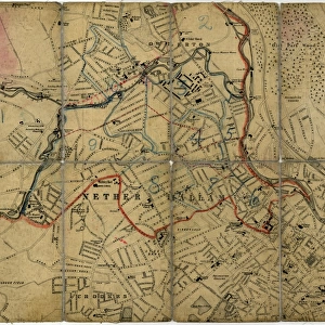
Fine Art Print : Plan of part of the townships of Sheffield and Nether Hallam, Sheffield, c. 1826


![]()
Fine Art Prints from Sheffield City Archives
Plan of part of the townships of Sheffield and Nether Hallam, Sheffield, c. 1826
Full title: Plan of part of the townships of Sheffield and Nether Hallam which is in dispute.
Includes John Addys house, Lidgate Field, Shales Moor Close, White House Lane or Walkley Road, Penistone Turnpike Road, old road from Owlerton to Sheffield, Green lane, Cleakham [Cleakum Inn], Morton Wheel and Morton Wheel Dam, River Dun and Bacons Island, waterworks, poor house, Bellefield House, Daniel hill, infirmary, Philadelphia, West Dun, Hillsborough Barracks, Bowling Green, a tavern [possibley the Cambridge public house], St Philips Church, Globe Works, Roscoe Place, Hoyle Street, Dun Street, Moor Fields, Green Lane, etc.
Dimensions: approx. 69 x 49 cm.
From an original at Sheffield Libraries: arc03896
Sheffield City Archives and Local Studies Library has an unrivalled collection of images of Sheffield, England
Media ID 19827424
© Sheffield City Council - All Rights Reserved
Fairbank Hillsborough Netherthorpe River Don Sheffield Upperthorpe Yorkshire Green Lane Hoyle Street Infirmary Road Moorfields Penistone Road Royal Infirmary St Philips Road Water Mills Water Power Waterworks Workhouses
A2 (42x59cm) Fine Art Print
Step back in time with this exquisite Fine Art Print from Media Storehouse. Featuring a detailed plan of part of the townships of Sheffield and Nether Hallam, as it appeared around 1826, this print offers a captivating glimpse into the history of this vibrant city. Highlighted in the plan are notable landmarks such as John Addy's house, Lidgate Field, Shales Moor Close, and White House Lane or Walkley Road. This intriguing map is a must-have for history enthusiasts, local residents, and anyone with an appreciation for the rich heritage of Sheffield. Printed on premium quality archival paper, this Fine Art Print is not only a beautiful addition to your home or office, but it is also a long-lasting investment in the stories of the past. Bring history to life with this stunning, authentic reproduction from Media Storehouse.
Our Fine Art Prints are printed on 100% acid free, PH neutral paper with archival properties. This printing method is used by museums and art collections to exhibit photographs and art reproductions. Hahnemühle certified studio for digital fine art printing. Printed on 308gsm Photo Rag Paper.
Our fine art prints are high-quality prints made using a paper called Photo Rag. This 100% cotton rag fibre paper is known for its exceptional image sharpness, rich colors, and high level of detail, making it a popular choice for professional photographers and artists. Photo rag paper is our clear recommendation for a fine art paper print. If you can afford to spend more on a higher quality paper, then Photo Rag is our clear recommendation for a fine art paper print.
Estimated Product Size is 59.4cm x 42cm (23.4" x 16.5")
These are individually made so all sizes are approximate
Artwork printed orientated as per the preview above, with landscape (horizontal) orientation to match the source image.
EDITORS COMMENTS
This print showcases a detailed "Plan of part of the townships of Sheffield and Nether Hallam" dating back to approximately 1826. The plan, which is in dispute, offers a fascinating glimpse into the historical landscape of Sheffield during that era. Spanning an impressive size of around 69 x 49 cm, this archival piece provides a wealth of information about various landmarks and locations within the townships. Highlighted on the plan are notable places such as John Addys house, Lidgate Field, Shales Moor Close, White House Lane (also known as Walkley Road), Penistone Turnpike Road, Owlerton to Sheffield old road, Green lane, Cleakham Inn (Cleakum Inn), Morton Wheel and Morton Wheel Dam. Additionally featured are significant elements like River Dun and Bacons Island, waterworks infrastructure, poor house facilities, Bellefield House residence, infirmary buildings including Philadelphia and West Dun sections. Other prominent sites depicted include Hillsborough Barracks along with Bowling Green recreational area. Furthermore St Philips Church stands out prominently alongside Globe Works factory complex while Roscoe Place intersects Hoyle Street and Dun Street in close proximity to Moor Fields. This remarkable print from Sheffield Libraries' collection at arc03896 not only preserves crucial historical details but also sheds light on lesser-known aspects such as workhouses in Watery Street or St Philips Road's connection to Daniel Hill. While exploring this image transports us back centuries ago it is important to note that commercial use should not be associated with it.
MADE IN THE UK
Safe Shipping with 30 Day Money Back Guarantee
FREE PERSONALISATION*
We are proud to offer a range of customisation features including Personalised Captions, Color Filters and Picture Zoom Tools
SECURE PAYMENTS
We happily accept a wide range of payment options so you can pay for the things you need in the way that is most convenient for you
* Options may vary by product and licensing agreement. Zoomed Pictures can be adjusted in the Basket.