Fine Art Print > Maps and Charts > Related Images
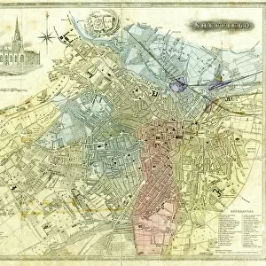
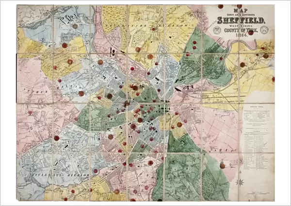
Fine Art Print : Map of the Town and Environs of Sheffield, 1864


![]()
Fine Art Prints from Sheffield City Archives
Map of the Town and Environs of Sheffield, 1864
Scale 1 inches : 1 mile. Board and church schools have been indicated at a later date and the ecclesiastical districts have been indicated by colouring.Original at Sheffield Archives ref. SY18/1
Sheffield City Archives and Local Studies Library has an unrivalled collection of images of Sheffield, England
Media ID 13987657
© Sheffield City Council
A2 (42x59cm) Fine Art Print
Discover the rich history of Sheffield with this exquisite Fine Art Print from Media Storehouse. This detailed map of the town and its environs, dating back to 1864, offers a fascinating glimpse into the past. Originally from the Sheffield City Archives, this map features the town's layout, including schools and ecclesiastical districts. The intricate details are brought to life with vibrant colors, making this a must-have for history enthusiasts and locals alike. The original map, housed at Sheffield Archives (SY18/1), has been carefully preserved for your enjoyment. Bring a piece of Sheffield's history into your home with this beautiful Fine Art Print.
Our Fine Art Prints are printed on 100% acid free, PH neutral paper with archival properties. This printing method is used by museums and art collections to exhibit photographs and art reproductions. Hahnemühle certified studio for digital fine art printing. Printed on 308gsm Photo Rag Paper.
Our fine art prints are high-quality prints made using a paper called Photo Rag. This 100% cotton rag fibre paper is known for its exceptional image sharpness, rich colors, and high level of detail, making it a popular choice for professional photographers and artists. Photo rag paper is our clear recommendation for a fine art paper print. If you can afford to spend more on a higher quality paper, then Photo Rag is our clear recommendation for a fine art paper print.
Estimated Image Size (if not cropped) is 54.7cm x 42cm (21.5" x 16.5")
Estimated Product Size is 59.4cm x 42cm (23.4" x 16.5")
These are individually made so all sizes are approximate
Artwork printed orientated as per the preview above, with landscape (horizontal) orientation to match the source image.
FEATURES IN THESE COLLECTIONS
> Maps and Charts
> Related Images
> Sheffield City Archives
> Maps and Plans
> Maps of Sheffield
EDITORS COMMENTS
This print showcases the intricate "Map of the Town and Environs of Sheffield" dating back to 1864. With a scale of 1 inch to 1 mile, this meticulously detailed map offers a fascinating glimpse into the city's past. The print highlights various landmarks such as board and church schools, which have been indicated at a later date, providing valuable insights into Sheffield's educational landscape during that era. What sets this particular map apart is its unique color-coded representation of ecclesiastical districts. Each district has been carefully colored, allowing viewers to easily identify and understand the religious divisions within Sheffield in 1864. This visual depiction adds an extra layer of historical significance to the map, shedding light on how religion played an integral role in shaping communities during that time. Preserved at Sheffield Archives under reference SY18/1, this original piece holds immense value for historians, researchers, and anyone interested in exploring Sheffield's rich heritage. It serves as a tangible link between our present-day understanding of the city and its vibrant past
MADE IN THE UK
Safe Shipping with 30 Day Money Back Guarantee
FREE PERSONALISATION*
We are proud to offer a range of customisation features including Personalised Captions, Color Filters and Picture Zoom Tools
SECURE PAYMENTS
We happily accept a wide range of payment options so you can pay for the things you need in the way that is most convenient for you
* Options may vary by product and licensing agreement. Zoomed Pictures can be adjusted in the Basket.