Fine Art Print > Sheffield City Archives > Maps and Plans > Bowen's County Maps, c. 1777
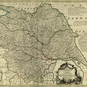
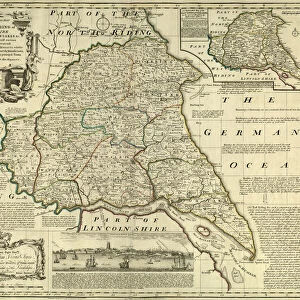
Fine Art Print : County Map of Yorkshire North Riding, c. 1777


![]()
Fine Art Prints from Sheffield City Archives
County Map of Yorkshire North Riding, c. 1777
From The Large English Atlas: or, a new set of map of all the counties of England and Wales drawn from the several surveys which have been hitherto been published. With three general maps of England, Scotland and Ireland, from the latest and best authorities, by Emanuel Bowen, Thomas Kitchin and others. London, printed and sold by T. Bowles, [c.1777]
Original at Sheffield Libraries: 912 STF
Sheffield City Archives and Local Studies Library has an unrivalled collection of images of Sheffield, England
Media ID 25501549
© Sheffield City Council - All Rights Reserved
Antique Map Bowens Map County Map Emanuel Bowen Old Map Thomas Kitchin York Yorkshire Cleveland Helmsley Middlesbrough Pickering Richmond Robin Hoods Bay Scarborough Selby Whitby Yorkshire Dales
A2 (42x59cm) Fine Art Print
Discover the rich history of Yorkshire North Riding with this exquisite fine art print from Media Storehouse. This beautiful reproduction showcases an intricately detailed County Map of Yorkshire North Riding, dating back to 1777. Originally from The Large English Atlas, this rare and captivating map is now available as a fine art print, perfect for adding a touch of history and character to any room in your home or office. With its intricate lines and vibrant colors, this print is not only an accurate representation of the county's borders but also a stunning work of art in its own right. Bring a piece of the past into your present with this unique and captivating addition to your collection.
Our Fine Art Prints are printed on 100% acid free, PH neutral paper with archival properties. This printing method is used by museums and art collections to exhibit photographs and art reproductions. Hahnemühle certified studio for digital fine art printing. Printed on 308gsm Photo Rag Paper.
Our fine art prints are high-quality prints made using a paper called Photo Rag. This 100% cotton rag fibre paper is known for its exceptional image sharpness, rich colors, and high level of detail, making it a popular choice for professional photographers and artists. Photo rag paper is our clear recommendation for a fine art paper print. If you can afford to spend more on a higher quality paper, then Photo Rag is our clear recommendation for a fine art paper print.
Estimated Image Size (if not cropped) is 55.3cm x 42cm (21.8" x 16.5")
Estimated Product Size is 59.4cm x 42cm (23.4" x 16.5")
These are individually made so all sizes are approximate
Artwork printed orientated as per the preview above, with landscape (horizontal) orientation to match the source image.
FEATURES IN THESE COLLECTIONS
> Sheffield City Archives
> Maps and Plans
> Bowen's County Maps, c. 1777
> Sheffield City Archives
> Maps and Plans
> Maps of Yorkshire
EDITORS COMMENTS
This print showcases a remarkable County Map of Yorkshire North Riding, dating back to approximately 1777. A true treasure from The Large English Atlas: or, a new set of maps of all the counties of England and Wales, this antique map was meticulously drawn by renowned cartographers Emanuel Bowen, Thomas Kitchin, and others. The intricate details on this historic map take us on a journey through time as we explore the diverse landscapes and towns that make up Yorkshire North Riding. From the bustling city of York to the picturesque countryside in Richmond and Helmsley, every corner is beautifully depicted with precision. As our eyes wander across the map's surface, we encounter notable landmarks such as Whitby Abbey overlooking Robin Hood's Bay and Scarborough Castle majestically perched upon its cliffs. We are transported to bustling market towns like Pickering and Northallerton while also discovering hidden gems like Stocksley nestled amidst rolling hills. This invaluable piece preserved at Sheffield Libraries allows us to delve into Yorkshire's rich history while marveling at its natural beauty. With references to Selby Abbey standing tall amidst lush greenery and the breathtaking Yorkshire Dales stretching out before us, it becomes evident why this region has captivated hearts for centuries. A testament to craftsmanship and historical significance, this County Map serves as an enduring reminder of our past while offering endless possibilities for exploration within one of England's most enchanting regions - Yorkshire North Riding.
MADE IN THE UK
Safe Shipping with 30 Day Money Back Guarantee
FREE PERSONALISATION*
We are proud to offer a range of customisation features including Personalised Captions, Color Filters and Picture Zoom Tools
SECURE PAYMENTS
We happily accept a wide range of payment options so you can pay for the things you need in the way that is most convenient for you
* Options may vary by product and licensing agreement. Zoomed Pictures can be adjusted in the Basket.