Fine Art Print > Maps and Charts > World
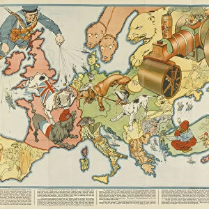
Fine Art Print : MAPS / WORLD / 1894


![]()
Fine Art Prints from Mary Evans Picture Library
MAPS / WORLD / 1894
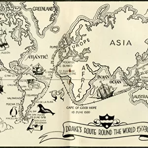
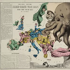
World map showing the European colonies
Mary Evans Picture Library makes available wonderful images created for people to enjoy over the centuries
Media ID 592844
© Mary Evans Picture Library 2015 - https://copyrighthub.org/s0/hub1/creation/maryevans/MaryEvansPictureID/10042277
A2 (42x59cm) Fine Art Print
Discover the rich history of global exploration and colonization with our exquisite selection of Fine Art Prints from Mary Evans Picture Library. This captivating piece, titled "Maps / World / 1894," transports you back in time as it showcases the world as it was known in 1894, with intricate detailing of European colonies. Add an air of sophistication and historical depth to your home or office with this stunning, museum-quality print. Order now and bring a piece of the past into your present.
Our Fine Art Prints are printed on 100% acid free, PH neutral paper with archival properties. This printing method is used by museums and art collections to exhibit photographs and art reproductions. Hahnemühle certified studio for digital fine art printing. Printed on 308gsm Photo Rag Paper.
Our fine art prints are high-quality prints made using a paper called Photo Rag. This 100% cotton rag fibre paper is known for its exceptional image sharpness, rich colors, and high level of detail, making it a popular choice for professional photographers and artists. Photo rag paper is our clear recommendation for a fine art paper print. If you can afford to spend more on a higher quality paper, then Photo Rag is our clear recommendation for a fine art paper print.
Estimated Image Size (if not cropped) is 54.8cm x 42cm (21.6" x 16.5")
Estimated Product Size is 59.4cm x 42cm (23.4" x 16.5")
These are individually made so all sizes are approximate
Artwork printed orientated as per the preview above, with landscape (horizontal) orientation to match the source image.
FEATURES IN THESE COLLECTIONS
> Europe
> Related Images
> Maps and Charts
> Early Maps
> Maps and Charts
> Related Images
> Maps and Charts
> World
EDITORS COMMENTS
This print from Mary Evans Picture Library showcases a historical world map dating back to 1894. The intricate details of this map provide a fascinating glimpse into the European colonies of that era, offering a snapshot of global history at the time.
As you study the map, you can see how European powers had established their presence and influence across various regions around the world. From Africa to Asia to the Americas, each colony is clearly marked, illustrating the extent of European imperialism during this period.
The colors and typography used in this map add to its charm and authenticity, making it a valuable piece for history enthusiasts and collectors alike. It serves as a reminder of how borders have shifted over time and how colonialism has shaped our modern world.
Whether displayed in a home library or office space, this vintage map is sure to spark conversations and inspire curiosity about past civilizations and geopolitical dynamics. It's not just a decorative piece but also an educational tool that invites viewers to explore different cultures and histories through cartography.
Overall, this print is more than just a visual representation of geographical locations; it's a window into the past that encourages us to reflect on our shared human experience throughout centuries.
MADE IN THE UK
Safe Shipping with 30 Day Money Back Guarantee
FREE PERSONALISATION*
We are proud to offer a range of customisation features including Personalised Captions, Color Filters and Picture Zoom Tools
SECURE PAYMENTS
We happily accept a wide range of payment options so you can pay for the things you need in the way that is most convenient for you
* Options may vary by product and licensing agreement. Zoomed Pictures can be adjusted in the Basket.