Fine Art Print > Arts > Artists > H > Jodocus Hondius
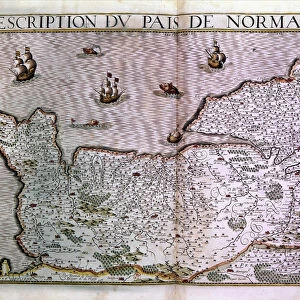
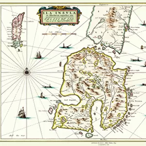
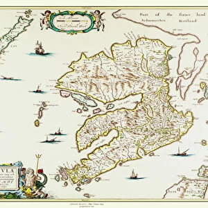
Fine Art Print : Old Map of the Isle of Islay Scotland 1654 by Johan Blaeu from the Atlas Novus


![]()
Fine Art Prints from MapSeeker
Old Map of the Isle of Islay Scotland 1654 by Johan Blaeu from the Atlas Novus
This detailed and most attractive reproduction map of The Isle of Islay has been carefully art worked from a scan of an antique original. The famous firm of Dutch cartographers and publishers was established in the late 16th century by Willem Janszoon Blaeu in Amsterdam. Blaeu was a maker of globes and scientific instruments and purchased some of his early map plates from Jodocus Hondius. From this small beginning was to emerge one of the largest and most prolific map publishing houses of the seventeenth century
Welcome to the Mapseeker Image library and enter an historic gateway to one of the largest on-line collections of Historic Maps, Nostalgic Views, Vista's and Panorama's from a World gone by.
Media ID 20347816
Blaeu Blaeu Family Blaue Map Historic Map Johan Blaeu Johan Blaeu Map Old Blaue Map Isle Of Islay
A2 (42x59cm) Fine Art Print
Discover the rich history of the Isle of Islay with our exquisite Fine Art Print of the Old Map of Islay Scotland from 1654, meticulously reproduced from the Atlas Novus by Johan Blaeu. This captivating and intricately detailed map, brought to you by Media Storehouse and MapSeeker, showcases the Isle of Islay as it appeared over three centuries ago. Each print is carefully crafted from a high-resolution scan of an original antique map, ensuring the preservation of historical accuracy and artistic beauty. Add a touch of history and charm to your home or office with this stunning Fine Art Print of the Old Map of Islay Scotland.
Our Fine Art Prints are printed on 100% acid free, PH neutral paper with archival properties. This printing method is used by museums and art collections to exhibit photographs and art reproductions. Hahnemühle certified studio for digital fine art printing. Printed on 308gsm Photo Rag Paper.
Our fine art prints are high-quality prints made using a paper called Photo Rag. This 100% cotton rag fibre paper is known for its exceptional image sharpness, rich colors, and high level of detail, making it a popular choice for professional photographers and artists. Photo rag paper is our clear recommendation for a fine art paper print. If you can afford to spend more on a higher quality paper, then Photo Rag is our clear recommendation for a fine art paper print.
Estimated Image Size (if not cropped) is 59.4cm x 39.6cm (23.4" x 15.6")
Estimated Product Size is 59.4cm x 42cm (23.4" x 16.5")
These are individually made so all sizes are approximate
Artwork printed orientated as per the preview above, with landscape (horizontal) orientation to match the source image.
FEATURES IN THESE COLLECTIONS
> Arts
> Artists
> B
> Willem Blaeu
> Arts
> Artists
> H
> Jodocus Hondius
> Arts
> Photorealistic artworks
> Detailed art pieces
> Masterful detailing in art
> Europe
> United Kingdom
> Scotland
> Maps
> Europe
> United Kingdom
> Scotland
> Posters
> Europe
> United Kingdom
> Scotland
> Related Images
> Maps and Charts
> Early Maps
> Maps and Charts
> Related Images
> Maps and Charts
> Willem Janszoon Blaeu
> MapSeeker
> Maps from the British Isles
> Scotland and Counties PORTFOLIO
EDITORS COMMENTS
This beautifully crafted reproduction of the "Old Map of the Isle of Islay Scotland 1654" by Johan Blaeu takes us back in time to explore the rich history and captivating landscapes of this enchanting Scottish island. Carefully art worked from a scan of an antique original, this detailed map showcases the expertise and precision that made Blaeu's cartography renowned. The famous Dutch firm established by Willem Janszoon Blaeu in Amsterdam during the late 16th century was not only a publisher but also a maker of globes and scientific instruments. This small beginning would eventually lead to one of the largest and most prolific map publishing houses of the seventeenth century. As we delve into this historic map, we uncover fascinating insights into Islay's past. From its charming villages to its rugged coastlines, every detail is meticulously depicted, allowing us to envision life on this remote island centuries ago. The intricate illustrations transport us through time as we imagine sailors navigating these waters or locals traversing ancient paths. Whether you are an avid historian or simply captivated by maps, this reproduction offers a glimpse into Islay's heritage that is both educational and visually stunning. Hang it proudly on your wall or use it as a conversation starter; either way, let yourself be transported to another era with this remarkable piece of history captured on paper.
MADE IN THE UK
Safe Shipping with 30 Day Money Back Guarantee
FREE PERSONALISATION*
We are proud to offer a range of customisation features including Personalised Captions, Color Filters and Picture Zoom Tools
SECURE PAYMENTS
We happily accept a wide range of payment options so you can pay for the things you need in the way that is most convenient for you
* Options may vary by product and licensing agreement. Zoomed Pictures can be adjusted in the Basket.