Fine Art Print > Europe > United Kingdom > England > London > Museums > British Library
Fine Art Print : Saxtons Map of Norfolk, 1574, (1944). Creator: Christopher Saxton
. Creator: Christopher Saxton")


![]()
Fine Art Prints from Heritage Images
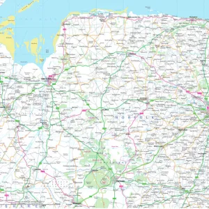
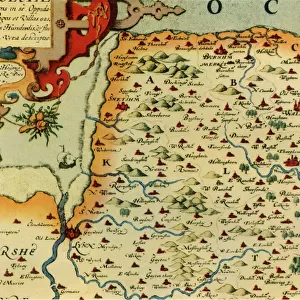
Saxtons Map of Norfolk, 1574, (1944). Creator: Christopher Saxton
Saxtons Map of Norfolk, 1574, (1944). Detail of the county of Norfolk, showing rivers, towns and villages, and a ship in The Wash. One of 35 coloured maps in " Atlas of the Counties of England and Wales", the first atlas of any country, made by Christopher Saxton. Manuscript in the British Library in London. From " British Maps and Map-Makers", by Edward Lynam. [Collins, London, 1944]
Heritage Images features heritage image collections
Media ID 19777284
© The Print Collector/Heritage Images
Britain In Pictures Christopher Coastline Collins Edward Edward Lynam Elizabethan Lynam Norfolk Rivers Social History William Collins William Collins And Sons William Collins Sons Christopher Saxton Saxton The Wash
A2 (42x59cm) Fine Art Print
Step back in time with our exquisite Saxtons Map of Norfolk, 1574, (1944) from Media Storehouse. This fine art print, sourced from Heritage Images, showcases a captivating detail of the county of Norfolk as it appeared over 400 years ago. Witness the intricate depiction of rivers, towns, and villages, including a ship in The Wash. Bring history into your home and transport yourself to a bygone era with this beautiful and intriguing piece of cartographic art.
Our Fine Art Prints are printed on 100% acid free, PH neutral paper with archival properties. This printing method is used by museums and art collections to exhibit photographs and art reproductions. Hahnemühle certified studio for digital fine art printing. Printed on 308gsm Photo Rag Paper.
Our fine art prints are high-quality prints made using a paper called Photo Rag. This 100% cotton rag fibre paper is known for its exceptional image sharpness, rich colors, and high level of detail, making it a popular choice for professional photographers and artists. Photo rag paper is our clear recommendation for a fine art paper print. If you can afford to spend more on a higher quality paper, then Photo Rag is our clear recommendation for a fine art paper print.
Estimated Image Size (if not cropped) is 52.3cm x 42cm (20.6" x 16.5")
Estimated Product Size is 59.4cm x 42cm (23.4" x 16.5")
These are individually made so all sizes are approximate
Artwork printed orientated as per the preview above, with landscape (horizontal) orientation to match the source image.
FEATURES IN THESE COLLECTIONS
> Animals
> Mammals
> Muridae
> Fortior
> Arts
> Artists
> C
> William Collins
> Arts
> Artists
> S
> Christopher Saxton
> Arts
> Landscape paintings
> Waterfall and river artworks
> River artworks
> Europe
> United Kingdom
> England
> London
> Museums
> British Library
> Europe
> United Kingdom
> England
> Maps
> Europe
> United Kingdom
> England
> Norfolk
> Related Images
> Europe
> United Kingdom
> England
> Rivers
> Europe
> United Kingdom
> Wales
> Maps
> Europe
> United Kingdom
> Wales
> Posters
EDITORS COMMENTS
This print showcases Saxtons Map of Norfolk from 1574, a remarkable piece of cartographic history. Created by Christopher Saxton and featured in the "Atlas of the Counties of England and Wales" this map is considered the first atlas ever made for any country. The intricate detail captured in this particular section highlights the county of Norfolk, revealing its rivers, towns, villages, and even a ship sailing through The Wash. The vibrant colors bring life to this centuries-old map, allowing us to appreciate both its artistic beauty and historical significance. Preserved as a manuscript in the British Library in London, it serves as an invaluable resource for researchers and enthusiasts alike. Edward Lynam's book "British Maps and Map-Makers" sheds light on the importance of these maps throughout British history. In this photograph print from 1944, we witness a fascinating intersection between past and present—a glimpse into how people perceived geography during Elizabethan times juxtaposed with mid-20th century Britain. As we explore this image further, we are reminded that maps not only provide geographical information but also offer insights into social history. They reflect cultural contexts while shaping our understanding of places over time. This extraordinary print invites us to delve into Norfolk's rich heritage while appreciating Christopher Saxton's pioneering work in mapping England's counties.
MADE IN THE UK
Safe Shipping with 30 Day Money Back Guarantee
FREE PERSONALISATION*
We are proud to offer a range of customisation features including Personalised Captions, Color Filters and Picture Zoom Tools
SECURE PAYMENTS
We happily accept a wide range of payment options so you can pay for the things you need in the way that is most convenient for you
* Options may vary by product and licensing agreement. Zoomed Pictures can be adjusted in the Basket.