mail_outline sales@mediastorehouse.com
Framed Print
Antique Framed Print
Premium Framed Print
Canvas Print
Metal Print
Photographic Print
Poster Print
Fine Art Print
Mounted Print
Glass Frame
Acrylic Blox
Jigsaw Puzzle
Tote Bag
Photo Mug
Greetings Card
Postcard
Cushion
Mouse Mat
Glass Place Mat
Glass Coaster
County of Suffolk by Christopher Saxton, c. 1569. Reprint dated c. 1650SVFFOLCIAE COMITATVS ACC VRATA DESCRIPTIO, VNA CVM SINGVLIS HVNDREDIS ET FLVMINIBUS ET EODEM. Auctore Chriftophoro Saxton [c.1569] Printed and sould by P
Saxtons Map of Norfolk, 1574, (1944). Creator: Christopher SaxtonSaxtons Map of Norfolk, 1574, (1944). Detail of the county of Norfolk, showing rivers, towns and villages, and a ship in The Wash
A Map of Westmorland and Cumberland, 1576 (hand-coloured engraving)985982 A Map of Westmorland and Cumberland, 1576 (hand-coloured engraving) by Saxton, Christopher (c.1542-c.1610); 38x48.5 cm; Private Collection; (add.info)
Elizabeth I Saxton Atlas, 16th century (engraving)3118913 Elizabeth I Saxton Atlas, 16th century (engraving); (add.info.: Elizabeth I Saxton Atlas, the frontispiece to Christopher Saxton's Atlas of England and Wales)
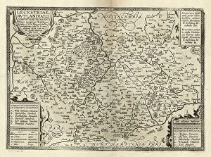
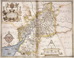
Counties of Leicester and Rutland, c. 1576. Reprint of 1602Full title: `LECESTRIAE, RVTLANDIAEQ. COMITATVM DELINEATIO. Primum descripta per Christaferum Saxton. A 1576. Nunc vero auctior emendatiorque. adiectis de Novo plusquam LXXX
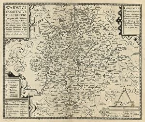
County of Warwick by William Smith, c. 1600 (after Saxton, c. 1574)`WARWICI COMITATVS DESCRIPTIO. Quan primus aeditit Christophorus Saxton. Anno 1576. Nunc de integro correcta. aucta. et restituta. Cui adduntur (praeter 60)
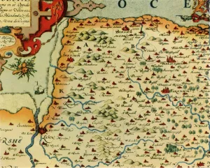
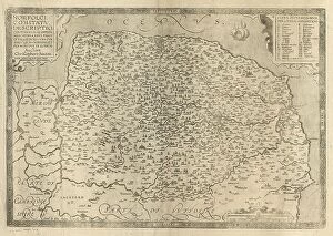
County of Norfolk by Christopher Saxton, c. 1574. Reprint of 1641`NORFOLCIAE COMITATVS DESCRIPTIO CONTINENS in SE OPPIDA MERCATORIA XXVI. Pagos er Villas DCXXV. Vna cvm Singvlis Hundredis, et flvminibvs in eodem. Auctore Christophoro Saxton
Gloucester(shire), 1579 (hand-coloured engraving)985997 Gloucester(shire), 1579 (hand-coloured engraving) by Saxton, Christopher (c.1542-c.1610); 41.5x55 cm; Private Collection; (add.info.: Gloucester(shire); Glocestriae
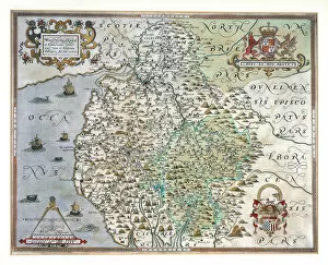
Cartouche by A. Ryther on Saxtons Map of Durham, 1576, (1944). Creator: Augustine RytherCartouche by A. Ryther on Saxtons Map of Durham, 1576, (1944). Detail on a map the county of Durham, (the Latin word Dunelmensis means of or from Durham)
Queen Elizabeth I enthroned - frontispiece, from Atlas of England and Wales by Christopher Saxton, 1579Cartography, Great Britain, 16th century. Christopher Saxton, Atlas of England and Wales (1579), frontispiece, Queen Elizabeth I enthroned