Fine Art Print > Arts > Artists > A > John White Alexander
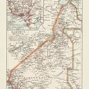
Fine Art Print : Map Showing the German Cameroon Colony, 1916. Creator: Unknown


![]()
Fine Art Prints from Heritage Images
Map Showing the German Cameroon Colony, 1916. Creator: Unknown
Map Showing the German Cameroon Colony, 1916. German Cameroon was an African colony of the German Empire from 1884 to 1916. Following Germanys defeat, the Treaty of Versailles divided the territory between Great Britain and France. From " The War Illustrated Album De Luxe - Volume IV. The Summer Campaign - 1915", edited by J. A. Hammerton. [The Amalgamated Press, Limited, London, 1916]
Heritage Images features heritage image collections
Media ID 19661303
© The Print Collector/Heritage Images
Album Amalgamated Press Amalgamated Press Limited Amalgamated Press Ltd Cameroon Congo Congo Africa Democratic Republic Of The Congo German Empire Hammerton Hammerton J A Hammerton Ja Hammerton Sir John Alexander J A Hammerton Ja Hammerton John Hammerton Nigeria Sir John Alexander Sir John Alexander Hammerton Sir John Hammerton Strategic Strategy Summer Campaign 1915 Territorial Territory The Amalgamated Press The War Illustrated
A2 (42x59cm) Fine Art Print
Step back in time with our exquisite selection of Fine Art Prints from Media Storehouse. This captivating Map Showing the German Cameroon Colony, 1916, from Heritage Images, showcases the historical boundaries of German Cameroon during its tenure as a German colony from 1884 to 1916. With intricate detailing and authentic vintage charm, this print is an essential addition to any history or geography enthusiast's collection. Unknown in origin, this map is a testament to the rich and complex history of Africa and its colonial past. Add a touch of history and sophistication to your home or office decor with this stunning Fine Art Print.
Our Fine Art Prints are printed on 100% acid free, PH neutral paper with archival properties. This printing method is used by museums and art collections to exhibit photographs and art reproductions. Hahnemühle certified studio for digital fine art printing. Printed on 308gsm Photo Rag Paper.
Our fine art prints are high-quality prints made using a paper called Photo Rag. This 100% cotton rag fibre paper is known for its exceptional image sharpness, rich colors, and high level of detail, making it a popular choice for professional photographers and artists. Photo rag paper is our clear recommendation for a fine art paper print. If you can afford to spend more on a higher quality paper, then Photo Rag is our clear recommendation for a fine art paper print.
Estimated Image Size (if not cropped) is 42cm x 52.2cm (16.5" x 20.6")
Estimated Product Size is 42cm x 59.4cm (16.5" x 23.4")
These are individually made so all sizes are approximate
Artwork printed orientated as per the preview above, with portrait (vertical) orientation to match the source image.
FEATURES IN THESE COLLECTIONS
> Africa
> Cameroon
> Related Images
> Africa
> Democratic Republic of the Congo
> Related Images
> Africa
> Nigeria
> Related Images
> Africa
> Related Images
> Africa
> Republic of the Congo
> Maps
> Arts
> Artists
> A
> John White Alexander
> Arts
> Artists
> W
> John White
EDITORS COMMENTS
This print showcases a historical map titled "Map Showing the German Cameroon Colony, 1916". Created by an unknown artist, this map depicts the African colony of German Cameroon during its existence from 1884 to 1916. The German Empire ruled over this territory until their defeat in World War I, which led to the division of the region between Great Britain and France through the Treaty of Versailles. The photograph is sourced from "The War Illustrated Album De Luxe - Volume IV. The Summer Campaign - 1915" edited by J. A. Hammerton and published by The Amalgamated Press Limited in London in 1916. It captures a significant moment in history when colonial powers were vying for control over African territories. The map represents not only a geographical depiction but also symbolizes concepts such as colonialism, strategy, and territorial disputes. It highlights how Africa was divided among European powers during this period. Although we do not know who specifically created this map, it serves as a valuable historical artifact that sheds light on Germany's presence in Africa during the early 20th century. This image offers viewers an opportunity to explore the impact of World War I on global politics and colonization efforts at that time.
MADE IN THE UK
Safe Shipping with 30 Day Money Back Guarantee
FREE PERSONALISATION*
We are proud to offer a range of customisation features including Personalised Captions, Color Filters and Picture Zoom Tools
SECURE PAYMENTS
We happily accept a wide range of payment options so you can pay for the things you need in the way that is most convenient for you
* Options may vary by product and licensing agreement. Zoomed Pictures can be adjusted in the Basket.