Fine Art Print > Europe > United Kingdom > England > London > Politics > John Major
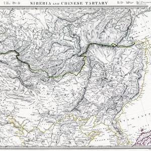
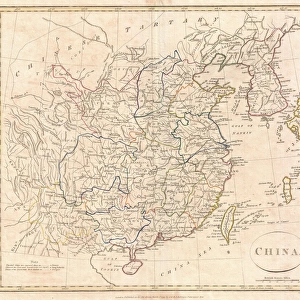
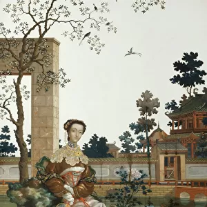
Fine Art Print : CHINA: FUJIAN MAP, 1662. Engraved map of the province of Fujian, China, also showing the Strait of Taiwan and part of Taiwan (Formosa) from Jan Blaeus Atlas Major published in Amsterdam in 1662
 from Jan Blaeus Atlas Major published in Amsterdam in 1662")


![]()
Fine Art Prints from Granger
CHINA: FUJIAN MAP, 1662. Engraved map of the province of Fujian, China, also showing the Strait of Taiwan and part of Taiwan (Formosa) from Jan Blaeus Atlas Major published in Amsterdam in 1662
Granger holds millions of images spanning more than 25,000 years of world history, from before the Stone Age to the dawn of the Space Age
Media ID 7515197
1662 Atlas Blaeu Chinese Ching Dynasty Dutch Fujian Province Atlas Maior Formosa Taiwan
A2 (42x59cm) Fine Art Print
Discover the rich history and culture of China with our exquisite Fine Art Print of the Fujian Map, 1662. This beautifully detailed engraving, taken from the renowned Jan Blaeus Atlas Major published in Amsterdam, offers a captivating glimpse into the past. The map showcases the province of Fujian, China, with its intricate coastline, and includes the Strait of Taiwan and a portion of Taiwan (Formosa). Bring a piece of historical cartography into your home or office and transport yourself back in time with this stunning work of art.
Our Fine Art Prints are printed on 100% acid free, PH neutral paper with archival properties. This printing method is used by museums and art collections to exhibit photographs and art reproductions. Hahnemühle certified studio for digital fine art printing. Printed on 308gsm Photo Rag Paper.
Our fine art prints are high-quality prints made using a paper called Photo Rag. This 100% cotton rag fibre paper is known for its exceptional image sharpness, rich colors, and high level of detail, making it a popular choice for professional photographers and artists. Photo rag paper is our clear recommendation for a fine art paper print. If you can afford to spend more on a higher quality paper, then Photo Rag is our clear recommendation for a fine art paper print.
Estimated Image Size (if not cropped) is 50.2cm x 42cm (19.8" x 16.5")
Estimated Product Size is 59.4cm x 42cm (23.4" x 16.5")
These are individually made so all sizes are approximate
Artwork printed orientated as per the preview above, with landscape (horizontal) orientation to match the source image.
FEATURES IN THESE COLLECTIONS
> Animals
> Mammals
> Didelphidae
> Formosa
> Arts
> Artists
> B
> Jan Blaeu
> Asia
> Taiwan
> Related Images
> Europe
> United Kingdom
> England
> London
> Politics
> John Major
> Historic
> Ancient civilizations
> Chinese Dynasties
> Historic
> Chinese dynasties paintings
> Maps and Charts
> Related Images
> Granger Art on Demand
> Maps
EDITORS COMMENTS
This print showcases a remarkable piece of cartographic history - the "CHINA: FUJIAN MAP, 1662". Engraved by the skilled hands of John Blaeu and published in Amsterdam during the same year, this map offers an exquisite depiction of Fujian province in China. With intricate details and precision, it not only encompasses the entire province but also reveals a glimpse of Taiwan (then known as Formosa) and the Strait of Taiwan. The fusion of Dutch and Chinese influences is evident in this masterpiece, reflecting cultural exchange during that era. The engraving itself is a testament to Blaeu's expertise as he skillfully captures every contour, river, and landmark with utmost accuracy. It serves as a valuable historical artifact from the Ching Dynasty period. Jan Blaeu's Atlas Major was renowned for its comprehensive collection of maps from around the world. This particular map holds significance due to its portrayal of Fujian Province - an area rich in natural beauty and cultural heritage. As we gaze upon this stunning print, we are transported back to 1662 when exploration was at its peak. It reminds us how maps were once treasured possessions that guided adventurers through uncharted territories. Thanks to Granger Art on Demand's impeccable preservation efforts, we can now admire this extraordinary engraving that seamlessly merges artistry with geographic knowledge.
MADE IN THE UK
Safe Shipping with 30 Day Money Back Guarantee
FREE PERSONALISATION*
We are proud to offer a range of customisation features including Personalised Captions, Color Filters and Picture Zoom Tools
SECURE PAYMENTS
We happily accept a wide range of payment options so you can pay for the things you need in the way that is most convenient for you
* Options may vary by product and licensing agreement. Zoomed Pictures can be adjusted in the Basket.