Fine Art Print > Arts > Street art graffiti > Digital art > Vector illustrations
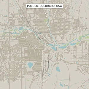
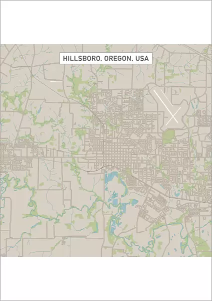
Fine Art Print : Hillsboro Oregon US City Street Map


![]()
Fine Art Prints from Fine Art Storehouse
Hillsboro Oregon US City Street Map
Vector Illustration of a City Street Map of Hillsboro, Oregon, USA. Scale 1:60, 000.
All source data is in the public domain.
U.S. Geological Survey, US Topo
Used Layers:
USGS The National Map: National Hydrography Dataset (NHD)
USGS The National Map: National Transportation Dataset (NTD)
Unleash your creativity and transform your space into a visual masterpiece!
Frank Ramspott
Media ID 15055011
© Frank Ramspott, all rights reserved
Aerial View City Map Computer Graphic Directly Above Downtown District Gray Oregon Road Map Text Digitally Generated Image Green Color Hillsboro White Color
A2 (42x59cm) Fine Art Print
Discover the unique charm of Hillsboro, Oregon with this exquisite Fine Art Print by Frank Ramspott from Media Storehouse. This stunning vector illustration of a city street map showcases the intricate details of the US city with a scale of 1:60,000. Meticulously crafted using public domain data, this fine art print is not just a map, but a work of art that brings the essence of Hillsboro right into your home or office. Add a touch of sophistication and local flair to your space with this beautiful and accurate representation of the city. Order yours today from Media Storehouse and let the beauty of Hillsboro inspire you every day.
Our Fine Art Prints are printed on 100% acid free, PH neutral paper with archival properties. This printing method is used by museums and art collections to exhibit photographs and art reproductions. Hahnemühle certified studio for digital fine art printing. Printed on 308gsm Photo Rag Paper.
Our fine art prints are high-quality prints made using a paper called Photo Rag. This 100% cotton rag fibre paper is known for its exceptional image sharpness, rich colors, and high level of detail, making it a popular choice for professional photographers and artists. Photo rag paper is our clear recommendation for a fine art paper print. If you can afford to spend more on a higher quality paper, then Photo Rag is our clear recommendation for a fine art paper print.
Estimated Image Size (if not cropped) is 42cm x 42cm (16.5" x 16.5")
Estimated Product Size is 42cm x 59.4cm (16.5" x 23.4")
These are individually made so all sizes are approximate
Artwork printed orientated as per the preview above, with landscape (horizontal) or portrait (vertical) orientation to match the source image.
FEATURES IN THESE COLLECTIONS
> Aerial Photography
> Related Images
> Animals
> Insects
> Hemiptera
> Green Scale
> Arts
> Contemporary art
> Digital artwork
> Street art
> Arts
> Landscape paintings
> Waterfall and river artworks
> River artworks
> Arts
> Portraits
> Pop art gallery
> Street art portraits
> Arts
> Street art graffiti
> Digital art
> Digital paintings
> Arts
> Street art graffiti
> Digital art
> Vector illustrations
> Maps and Charts
> Geological Map
> Maps and Charts
> Related Images
> North America
> United States of America
> Lakes
> Related Images
> Fine Art Storehouse
> Map
> Street Maps
> Fine Art Storehouse
> Map
> USA Maps
EDITORS COMMENTS
This print showcases a meticulously detailed city street map of Hillsboro, Oregon, USA. With a scale of 1:60,000, every intricate feature is beautifully illustrated in this vector illustration. The source data used for creating this masterpiece is all from the public domain and includes USGS The National Map: National Hydrography Dataset (NHD) and USGS The National Map: National Transportation Dataset (NTD). The image captures the essence of Hillsboro's downtown district with its bustling streets and vibrant atmosphere. A serene lake and river add to the scenic beauty of this charming city. From major roads to hidden alleys, every corner is depicted on this road map. The artful design combines various colors such as gray, blue, white, and green to create an aesthetically pleasing composition. Digitally generated with precision and attention to detail, this computer graphic offers an aerial view directly above the city. With no people present in the image, it allows viewers to focus solely on exploring the physical geography of Hillsboro through cartography. This unique piece by Frank Ramspott serves as both an informative tool for navigation enthusiasts and a visually striking artwork that can enhance any space or collection.
MADE IN THE UK
Safe Shipping with 30 Day Money Back Guarantee
FREE PERSONALISATION*
We are proud to offer a range of customisation features including Personalised Captions, Color Filters and Picture Zoom Tools
SECURE PAYMENTS
We happily accept a wide range of payment options so you can pay for the things you need in the way that is most convenient for you
* Options may vary by product and licensing agreement. Zoomed Pictures can be adjusted in the Basket.