Fine Art Print > Africa > Sudan > Maps
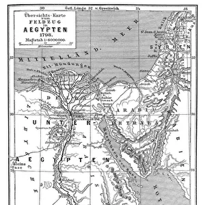
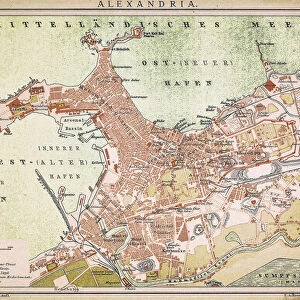
Fine Art Print : Map of Egypt and Sudan 1896


![]()
Fine Art Prints from Fine Art Storehouse
Map of Egypt and Sudan 1896
Andres Allgemeiner Handatlas - Bielefeld und Leipzig 1896
Unleash your creativity and transform your space into a visual masterpiece!
THEPALMER
Media ID 18356811
A2 (42x59cm) Fine Art Print
Discover the rich history and cultural wonders of Egypt and Sudan with this exquisite fine art print from Media Storehouse. Titled "Map of Egypt and Sudan" and hailing from the Andres Allgemeiner Handatlas published in Bielefeld and Leipzig in 1896, this vintage map by THEPALMER is a captivating representation of the regions as they were explored and documented over a century ago. With intricate detail and beautiful cartography, this fine art print makes a stunning addition to any home or office, transporting you back in time and inviting you to explore the mysteries of the ancient world.
Our Fine Art Prints are printed on 100% acid free, PH neutral paper with archival properties. This printing method is used by museums and art collections to exhibit photographs and art reproductions. Hahnemühle certified studio for digital fine art printing. Printed on 308gsm Photo Rag Paper.
Our fine art prints are high-quality prints made using a paper called Photo Rag. This 100% cotton rag fibre paper is known for its exceptional image sharpness, rich colors, and high level of detail, making it a popular choice for professional photographers and artists. Photo rag paper is our clear recommendation for a fine art paper print. If you can afford to spend more on a higher quality paper, then Photo Rag is our clear recommendation for a fine art paper print.
Estimated Image Size (if not cropped) is 38.7cm x 59.4cm (15.2" x 23.4")
Estimated Product Size is 42cm x 59.4cm (16.5" x 23.4")
These are individually made so all sizes are approximate
Artwork printed orientated as per the preview above, with portrait (vertical) orientation to match the source image.
FEATURES IN THESE COLLECTIONS
> Africa
> Egypt
> Related Images
> Africa
> Sudan
> Related Images
> Maps and Charts
> Related Images
> Fine Art Storehouse
> Map
> Historical Maps
EDITORS COMMENTS
In this print titled "Map of Egypt and Sudan 1896" we are transported back in time to the late 19th century, where cartography was an art form in itself. The intricate details and craftsmanship of this map, sourced from Andres Allgemeiner Handatlas - Bielefeld und Leipzig 1896, truly capture the essence of a bygone era. As we gaze upon this historical artifact, our eyes are immediately drawn to the rich colors that adorn its surface. Shades of deep blues represent water bodies like the Nile River and Lake Victoria, while earthy tones depict vast deserts and fertile lands. Every contour line meticulously etched onto the paper reveals mountains, valleys, and plateaus with remarkable precision. The Map of Egypt and Sudan transports us to a time when these regions were still under colonial rule. It serves as a reminder of their complex history intertwined with European powers seeking control over strategic territories. This print offers not only geographical information but also provides insights into political boundaries during that period. "The Palmer" has skillfully captured this piece from Fine Art Storehouse, allowing us to appreciate its beauty up close. Whether you're an avid historian or simply fascinated by vintage maps, this print is sure to ignite your imagination as you explore the intricacies of Egypt and Sudan's past through cartographic mastery.
MADE IN THE UK
Safe Shipping with 30 Day Money Back Guarantee
FREE PERSONALISATION*
We are proud to offer a range of customisation features including Personalised Captions, Color Filters and Picture Zoom Tools
SECURE PAYMENTS
We happily accept a wide range of payment options so you can pay for the things you need in the way that is most convenient for you
* Options may vary by product and licensing agreement. Zoomed Pictures can be adjusted in the Basket.