Fine Art Print > Europe > France > Canton > Landes
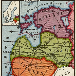
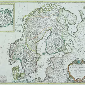
Fine Art Print : Map of Baltic states, lithograph, published in 1877


![]()
Fine Art Prints from Fine Art Storehouse
Map of Baltic states, lithograph, published in 1877
Historic map of Baltic states: Lithuania, Estonia, Latvia. Lithograph, published in 1877
Unleash your creativity and transform your space into a visual masterpiece!
Media ID 13666751
© ZU_09
78279 Baltic Countries Baltic Sea Contour Drawing Country Geographic Area Estonia European Culture Finland Image Date Island Land Latvia Lithuania Riga Topographic Map Topography Gulf Of Finland Image Created 19th Century
A2 (42x59cm) Fine Art Print
Step back in time with our exquisite 1877 Lithograph Map of the Baltic States from the Fine Art Storehouse. This historic print beautifully depicts the regions of Lithuania, Estonia, and Latvia during a pivotal period in their shared history. The intricate details and vibrant colors of this fine art lithograph transport you to a bygone era, making it a stunning addition to any home or office. Perfect for history enthusiasts, collectors, or those who appreciate the beauty of vintage maps, this map is not just a decorative piece but a window into the past. Bring a piece of history into your space with the Fine Art Storehouse's Map of the Baltic States.
Our Fine Art Prints are printed on 100% acid free, PH neutral paper with archival properties. This printing method is used by museums and art collections to exhibit photographs and art reproductions. Hahnemühle certified studio for digital fine art printing. Printed on 308gsm Photo Rag Paper.
Our fine art prints are high-quality prints made using a paper called Photo Rag. This 100% cotton rag fibre paper is known for its exceptional image sharpness, rich colors, and high level of detail, making it a popular choice for professional photographers and artists. Photo rag paper is our clear recommendation for a fine art paper print. If you can afford to spend more on a higher quality paper, then Photo Rag is our clear recommendation for a fine art paper print.
Estimated Image Size (if not cropped) is 42cm x 53.7cm (16.5" x 21.1")
Estimated Product Size is 42cm x 59.4cm (16.5" x 23.4")
These are individually made so all sizes are approximate
Artwork printed orientated as per the preview above, with portrait (vertical) orientation to match the source image.
FEATURES IN THESE COLLECTIONS
> Europe
> Estonia
> Related Images
> Europe
> Finland
> Related Images
> Europe
> France
> Canton
> Landes
> Europe
> Latvia
> Related Images
> Fine Art Storehouse
> Map
> Historical Maps
EDITORS COMMENTS
This lithograph, published in 1877, showcases a historic map of the Baltic states - Lithuania, Estonia, and Latvia. A true testament to European culture and cartography of the time, this antique engraved image offers a glimpse into the topography and land formations of these countries nestled along the Baltic Sea. The intricate details highlight key features such as the Gulf of Finland and Riga, while also encompassing smaller islands within this region. With its vertical composition and contour drawing style, this lithograph exudes an air of ancient history. Its creation in the 19th century adds to its allure as a valuable piece that captures not only geographical information but also reflects upon cultural significance. Each country's unique identity is subtly represented through symbols associated with Lithuanian, Latvian, and Estonian cultures. As we gaze at this remarkable print from 1877 - preserved beautifully even in modern times - it serves as a visual portal to explore the past. It reminds us of how these Baltic countries have evolved over time while retaining their distinct characteristics. This map holds immense historical value for scholars studying European geography or those seeking insight into bygone eras.
MADE IN THE UK
Safe Shipping with 30 Day Money Back Guarantee
FREE PERSONALISATION*
We are proud to offer a range of customisation features including Personalised Captions, Color Filters and Picture Zoom Tools
SECURE PAYMENTS
We happily accept a wide range of payment options so you can pay for the things you need in the way that is most convenient for you
* Options may vary by product and licensing agreement. Zoomed Pictures can be adjusted in the Basket.