Antique Framed Print > Europe > France > Canton > Landes
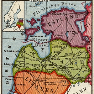
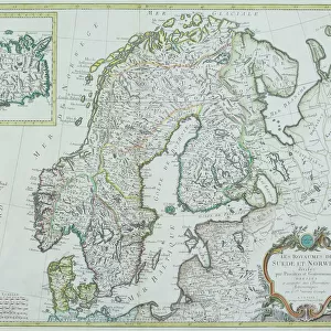
Antique Framed Print : Map of Baltic states, lithograph, published in 1877


![]()
Framed Photos from Fine Art Storehouse
Map of Baltic states, lithograph, published in 1877
Historic map of Baltic states: Lithuania, Estonia, Latvia. Lithograph, published in 1877
Unleash your creativity and transform your space into a visual masterpiece!
Media ID 13666751
© ZU_09
78279 Baltic Countries Baltic Sea Contour Drawing Country Geographic Area Estonia European Culture Finland Image Date Island Land Latvia Lithuania Riga Topographic Map Topography Gulf Of Finland Image Created 19th Century
14"x12" (36x31cm) Antique Frame
Bevelled wood effect frame, card mounted, 10x8 archival quality photo print. Overall outside dimensions 14x12 inches (36x31cm). Environmentally and ozone friendly, the Polycore® moulding has the look of real wood, is durable and light and easy to hang. Biodegradable and made with non-chlorinated gases (no toxic fumes) it is efficient; producing 100 tons of polystyrene can save 300 tons of trees! Prints are glazed with lightweight, shatterproof, optical clarity acrylic (providing the same general protection from the environment as glass). The back is stapled hardboard with a sawtooth hanger attached. Note: To minimise original artwork cropping, for optimum layout, and to ensure print is secure, the visible print may be marginally smaller
Bevelled Wood Effect Framed and Mounted Prints - Professionally Made and Ready to Hang
Estimated Image Size (if not cropped) is 19.1cm x 24.4cm (7.5" x 9.6")
Estimated Product Size is 31.2cm x 36.3cm (12.3" x 14.3")
These are individually made so all sizes are approximate
Artwork printed orientated as per the preview above, with portrait (vertical) orientation to match the source image.
FEATURES IN THESE COLLECTIONS
> Europe
> Estonia
> Related Images
> Europe
> Finland
> Related Images
> Europe
> France
> Canton
> Landes
> Europe
> Latvia
> Related Images
> Fine Art Storehouse
> Map
> Historical Maps
EDITORS COMMENTS
This lithograph, published in 1877, showcases a historic map of the Baltic states - Lithuania, Estonia, and Latvia. A true testament to European culture and cartography of the time, this antique engraved image offers a glimpse into the topography and land formations of these countries nestled along the Baltic Sea. The intricate details highlight key features such as the Gulf of Finland and Riga, while also encompassing smaller islands within this region. With its vertical composition and contour drawing style, this lithograph exudes an air of ancient history. Its creation in the 19th century adds to its allure as a valuable piece that captures not only geographical information but also reflects upon cultural significance. Each country's unique identity is subtly represented through symbols associated with Lithuanian, Latvian, and Estonian cultures. As we gaze at this remarkable print from 1877 - preserved beautifully even in modern times - it serves as a visual portal to explore the past. It reminds us of how these Baltic countries have evolved over time while retaining their distinct characteristics. This map holds immense historical value for scholars studying European geography or those seeking insight into bygone eras.
MADE IN THE UK
Safe Shipping with 30 Day Money Back Guarantee
FREE PERSONALISATION*
We are proud to offer a range of customisation features including Personalised Captions, Color Filters and Picture Zoom Tools
SECURE PAYMENTS
We happily accept a wide range of payment options so you can pay for the things you need in the way that is most convenient for you
* Options may vary by product and licensing agreement. Zoomed Pictures can be adjusted in the Basket.