Fine Art Print > Europe > United Kingdom > England > Maps
Fine Art Print : 1643, antiquity, archival, british isles, cartography, england, europe, geographical


![]()
Fine Art Prints from Fine Art Storehouse
1643, antiquity, archival, british isles, cartography, england, europe, geographical
1643, antiquity, archival, british isles, cartography, england, europe, geographical, geography, historical, map, nobody, old-fashioned, text, uk, vintage, Antique Maps, 89687337
Unleash your creativity and transform your space into a visual masterpiece!
Hemera Technologies
Media ID 14761238
© Getty Images
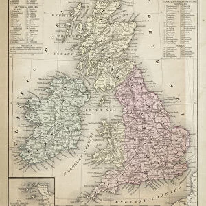
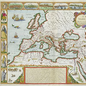
Antiquity British Isles Geographical Geography Text 1643
A2 (42x59cm) Fine Art Print
Step back in time with our exquisite selection of antique maps from the Media Storehouse Fine Art Prints range. This captivating piece, featuring a 1643 map of the British Isles and Europe, showcases intricate cartography and geographical details of the time. With a focus on England and the surrounding regions, this archival print transports you to a bygone era of old-fashioned charm and historical significance. Each print is meticulously produced using the highest quality materials and techniques, ensuring a long-lasting addition to your home or office decor. Bring the rich history of Europe into your space with this vintage, geographical masterpiece.
Our Fine Art Prints are printed on 100% acid free, PH neutral paper with archival properties. This printing method is used by museums and art collections to exhibit photographs and art reproductions. Hahnemühle certified studio for digital fine art printing. Printed on 308gsm Photo Rag Paper.
Our fine art prints are high-quality prints made using a paper called Photo Rag. This 100% cotton rag fibre paper is known for its exceptional image sharpness, rich colors, and high level of detail, making it a popular choice for professional photographers and artists. Photo rag paper is our clear recommendation for a fine art paper print. If you can afford to spend more on a higher quality paper, then Photo Rag is our clear recommendation for a fine art paper print.
Estimated Image Size (if not cropped) is 56.2cm x 42cm (22.1" x 16.5")
Estimated Product Size is 59.4cm x 42cm (23.4" x 16.5")
These are individually made so all sizes are approximate
Artwork printed orientated as per the preview above, with landscape (horizontal) orientation to match the source image.
FEATURES IN THESE COLLECTIONS
> Europe
> Related Images
> Europe
> United Kingdom
> England
> Maps
> Europe
> United Kingdom
> England
> Posters
> Europe
> United Kingdom
> England
> Related Images
> Europe
> United Kingdom
> Maps
> Maps and Charts
> Early Maps
> Maps and Charts
> Related Images
> Fine Art Storehouse
> Map
> Historical Maps
EDITORS COMMENTS
This print takes us back in time to the year 1643, immersing us in the antiquity and historical significance of the British Isles. The archival map, meticulously crafted with cartography expertise, showcases England and its place within Europe. Its vintage charm is evident through its old-fashioned text and intricate details that transport us to a bygone era. The map's geographical accuracy offers a glimpse into the past, allowing us to explore the landscapes and boundaries as they were centuries ago. It serves as a valuable resource for historians, researchers, or anyone with an interest in understanding how the British Isles fit into Europe's tapestry during this period. The absence of people in this image emphasizes its focus on geography rather than human activity. Instead, our attention is drawn to every line and contour that forms this remarkable piece of artistry. As we delve deeper into its rich history, we can appreciate both the craftsmanship behind it and Hemera Technologies' commitment to preserving these antique maps. Whether displayed in a personal collection or used for educational purposes, this print from Fine Art Storehouse captures not only an exquisite piece of cartographic heritage but also invites viewers to embark on a journey through time itself.
MADE IN THE UK
Safe Shipping with 30 Day Money Back Guarantee
FREE PERSONALISATION*
We are proud to offer a range of customisation features including Personalised Captions, Color Filters and Picture Zoom Tools
SECURE PAYMENTS
We happily accept a wide range of payment options so you can pay for the things you need in the way that is most convenient for you
* Options may vary by product and licensing agreement. Zoomed Pictures can be adjusted in the Basket.