Fine Art Print > Arts > Artists > B > Joan Blaeu
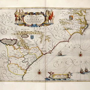
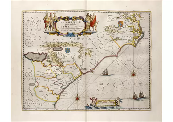
Fine Art Print : Map of Virginia and Florida, 1667 (hand-coloured engraving, vellum)
")


![]()
Fine Art Prints from Fine Art Finder
Map of Virginia and Florida, 1667 (hand-coloured engraving, vellum)
985771 Map of Virginia and Florida, 1667 (hand-coloured engraving, vellum) by Blaeu, Joan (1596-1673) (after); 54.6x35.7 (folio size) cm; Private Collection; (add.info.: Map of Virginia and Florida. Double-page spread from Volume XII: America, of the book Le Grand Atlas, ou Cosmographie Blaviane.... After Joan Blaeu (1596-1673). Hand-coloured engraving, vellum. Published in 1667. 54.6 x 35.7cm (folio size).); Photo eChristies Images; Dutch, out of copyright
Media ID 22202810
© Christie's Images / Bridgeman Images
1660s 1667 Artist Dutch Blaeu Cosmography Double Page Dutch Art Dutch Artist Florida Geographic Hand Colored Hand Coloring Hand Coloured Hand Colouring Hand Tinted Handcolored Joan Blaeu Johannes Johannes Willemszoon Blaeu Late 17th Century Late Seventeenth Century Navigation Navigational Equipment Netherlandish Artist Page Prints Touring Transit Vellum Virginia Volume Johannes Blaeu
A2 (42x59cm) Fine Art Print
Discover the rich history of the American Southeast with this exquisite hand-coloured engraving of a Map of Virginia and Florida from Bridgeman Images. Dating back to 1667, this rare and intricately detailed map is an essential addition to any fine art collection. Created by renowned cartographer Joan Blaeu, this map is a captivating representation of the territories of Virginia and Florida as they were known during the 17th century. With vibrant hand-coloring on vellum, this beautiful work of art is a testament to the skill and craftsmanship of its time. Bring a piece of history into your home or office with this stunning Map of Virginia and Florida from the Media Storehouse range of Fine Art Prints.
Our Fine Art Prints are printed on 100% acid free, PH neutral paper with archival properties. This printing method is used by museums and art collections to exhibit photographs and art reproductions. Hahnemühle certified studio for digital fine art printing. Printed on 308gsm Photo Rag Paper.
Our fine art prints are high-quality prints made using a paper called Photo Rag. This 100% cotton rag fibre paper is known for its exceptional image sharpness, rich colors, and high level of detail, making it a popular choice for professional photographers and artists. Photo rag paper is our clear recommendation for a fine art paper print. If you can afford to spend more on a higher quality paper, then Photo Rag is our clear recommendation for a fine art paper print.
Estimated Image Size (if not cropped) is 51.9cm x 42cm (20.4" x 16.5")
Estimated Product Size is 59.4cm x 42cm (23.4" x 16.5")
These are individually made so all sizes are approximate
Artwork printed orientated as per the preview above, with landscape (horizontal) orientation to match the source image.
FEATURES IN THESE COLLECTIONS
> Fine Art Finder
> Artists
> Joan (after) Blaeu
> Fine Art Finder
> Artists
> Joseph & Smit J. (fl.1870) Wolf
> Fine Art Finder
> Maps (celestial & Terrestrial)
> Arts
> Artists
> B
> Joan Blaeu
> Arts
> Artists
> Related Images
> Europe
> Related Images
> North America
> Related Images
> North America
> United States of America
> Florida
> Related Images
> North America
> United States of America
> Maps
> North America
> United States of America
> Virginia
> Related Images
EDITORS COMMENTS
This print showcases a stunning hand-coloured engraving of the "Map of Virginia and Florida" from 1667. Created by renowned Dutch cartographer Joan Blaeu, this intricate map is a true masterpiece of its time. Measuring at an impressive 54.6x35.7 cm, this double-page spread was originally featured in Volume XII: America, part of Blaeu's famous book Le Grand Atlas, ou Cosmographie Blaviane. The map itself depicts the regions of Virginia and Florida with remarkable detail and precision. The use of vellum as the medium adds to the overall allure and authenticity of this piece. Hand-tinted with vibrant colors, every stroke brings life to the landscapes portrayed on the map. As we explore this close-up view, we can appreciate not only the artistry but also its historical significance. This map served as a vital navigational tool for explorers during their journeys through North America in the late seventeenth century. With no people present in the image, our focus is solely on the meticulous craftsmanship that went into creating this work. The delicate engravings capture every contour and geographic feature with utmost accuracy. Through this print by Bridgeman Images, we are transported back to a time when maps were not just practical tools but works of art themselves. It serves as a reminder that even centuries later, these pieces continue to captivate us with their beauty and provide valuable insights into our past exploration and understanding of geography.
MADE IN THE UK
Safe Shipping with 30 Day Money Back Guarantee
FREE PERSONALISATION*
We are proud to offer a range of customisation features including Personalised Captions, Color Filters and Picture Zoom Tools
SECURE PAYMENTS
We happily accept a wide range of payment options so you can pay for the things you need in the way that is most convenient for you
* Options may vary by product and licensing agreement. Zoomed Pictures can be adjusted in the Basket.