Fine Art Print > Europe > United Kingdom > England > London > Museums > National Maritime Museum
Fine Art Print : Colour map of Dominica with detailed geographical observations, c.1760 (hand coloured engraving)
")


![]()
Fine Art Prints From Fine Art Finder
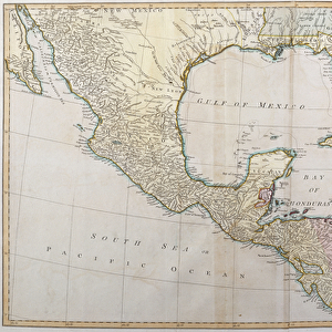
Colour map of Dominica with detailed geographical observations, c.1760 (hand coloured engraving)
7339471 Colour map of Dominica with detailed geographical observations, c.1760 (hand coloured engraving) by Jefferys, Thomas (c.1719-71); 63.5x48 cm; National Maritime Museum, London, UK; (add.info.: Creator: Thomas Jeffereys
Scale [circa 1:120, 000]. Contains an inset of Prince Rupert's Bay [circa 1:35, 000 (bar)].); © National Maritime Museum, Greenwich, London
Media ID 38519876
© © National Maritime Museum, Greenwich, London / Bridgeman Images
Caribbean Dominican Republic Isles 18e Siecle 18th Century 18th Centuries
A2 (42x59cm) Fine Art Print
Explore the beauty and history of Dominica through this exquisite fine art print from our Media Storehouse range! This stunning hand-coloured engraving by Thomas Jefferys (c.1719-71) is a rare glimpse into the island's geography as it was in 1760, complete with detailed observations that will transport you to another era.
Our Fine Art Prints are printed on 100% acid free, PH neutral paper with archival properties. This printing method is used by museums and art collections to exhibit photographs and art reproductions. Hahnemühle certified studio for digital fine art printing. Printed on 308gsm Photo Rag Paper.
Our fine art prints are high-quality prints made using a paper called Photo Rag. This 100% cotton rag fibre paper is known for its exceptional image sharpness, rich colors, and high level of detail, making it a popular choice for professional photographers and artists. Photo rag paper is our clear recommendation for a fine art paper print. If you can afford to spend more on a higher quality paper, then Photo Rag is our clear recommendation for a fine art paper print.
Estimated Image Size (if not cropped) is 42cm x 55.1cm (16.5" x 21.7")
Estimated Product Size is 42cm x 59.4cm (16.5" x 23.4")
These are individually made so all sizes are approximate
Artwork printed orientated as per the preview above, with portrait (vertical) orientation to match the source image.
FEATURES IN THESE COLLECTIONS
> Fine Art Finder
> Artists
> Thomas Jefferys
> Arts
> Artists
> H
> Thomas Hand
> Arts
> Artists
> J
> Thomas Jefferys
> Arts
> Photorealistic artworks
> Detailed art pieces
> Masterful detailing in art
> Europe
> United Kingdom
> England
> London
> Boroughs
> Greenwich
> Europe
> United Kingdom
> England
> London
> Museums
> Greenwich Heritage Centre
> Europe
> United Kingdom
> England
> London
> Museums
> National Maritime Museum
> Europe
> United Kingdom
> England
> London
> Towns
> Greenwich
> Europe
> United Kingdom
> Heritage Sites
> Maritime Greenwich
> Europe
> United Kingdom
> Maps
> Maps and Charts
> Early Maps
EDITORS COMMENTS
This stunning hand-colored engraving from the 18th century showcases a detailed colour map of Dominica, created by Thomas Jefferys. The intricate details and geographical observations on this map provide a fascinating glimpse into the island's landscape during that time period.
The map, measuring 63.5x48 cm, is part of the collection at the National Maritime Museum in London, UK. It offers a scale of approximately 1:120,000 and includes an inset of Prince Rupert's Bay at around 1:35,000 (bar). The vibrant colors used to highlight different regions on the map bring it to life and make it visually striking.
This historical artifact not only serves as a valuable tool for understanding the geography of Dominica in the past but also reflects the artistry and skill of cartographers like Jefferys. The level of detail captured in this engraving demonstrates the precision and dedication required to create such maps before modern technology made mapping more accessible.
Overall, this colour map of Dominica is a testament to both scientific exploration and artistic expression. It provides viewers with a window into history while showcasing the beauty and complexity of cartography in centuries past.
MADE IN THE UK
Safe Shipping with 30 Day Money Back Guarantee
FREE PERSONALISATION*
We are proud to offer a range of customisation features including Personalised Captions, Color Filters and Picture Zoom Tools
SECURE PAYMENTS
We happily accept a wide range of payment options so you can pay for the things you need in the way that is most convenient for you
* Options may vary by product and licensing agreement. Zoomed Pictures can be adjusted in the Basket.