Home > North America > United States of America > Massachusetts > Worcester
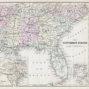
Map of the Carolinas with part of Georgia (engraving)
")
![]()
Wall Art and Photo Gifts from Fine Art Finder
Map of the Carolinas with part of Georgia (engraving)
AQS251295 Map of the Carolinas with part of Georgia (engraving) by American School, (19th century); American Antiquarian Society, Worcester, Massachusetts, USA; (add.info.: engraved for Dr. Gordons History of the American War ; showing the routes of Generals Greene, Morgan and Cornwallis as well as the major battle sites of the American Revolutionary War; ); eCourtesy, American Antiquarian Society; American, out of copyright
Media ID 22952846
© Courtesy, American Antiquarian Society / Bridgeman Images
East Coast North Carolina South Carolina Southern States
FEATURES IN THESE COLLECTIONS
> Arts
> Artists
> Related Images
> Arts
> Landscape paintings
> Waterfall and river artworks
> River artworks
> Fine Art Finder
> Artists
> American School
> Fine Art Finder
> Artists
> Photographer American
> Fine Art Finder
> Maps (celestial & Terrestrial)
> North America
> United States of America
> Georgia
> Related Images
> North America
> United States of America
> Maps
> North America
> United States of America
> Massachusetts
> Worcester
> North America
> United States of America
> North Carolina
> Related Images
> North America
> United States of America
> South Carolina
> Related Images
EDITORS COMMENTS
This print showcases a historical engraving titled "Map of the Carolinas with part of Georgia" created by the American School in the 19th century. Housed at the American Antiquarian Society in Worcester, Massachusetts, this remarkable piece offers a glimpse into America's past. Engraved for Dr. Gordon's History of the American War, this map provides valuable insights into the routes taken by Generals Greene, Morgan, and Cornwallis during the American Revolutionary War. It also highlights major battle sites that played crucial roles in shaping our nation's history. The intricate details on this map allow us to explore not only the coastlines and rivers but also gain an understanding of topography and military campaigns throughout these southern states. From North Carolina to South Carolina and extending into parts of Georgia, this map captures both mountainous regions and coastal areas along the East Coast. As we gaze upon this image, we are transported back in time to witness pivotal moments that shaped our country's independence. The significance lies not only in its historical accuracy but also as a testament to America's resilience and determination during times of conflict. Thanks to Bridgeman Images' fine art finder collection, we can now appreciate this extraordinary piece from afar while honoring its legacy as an invaluable resource for studying our nation's past.
MADE IN THE UK
Safe Shipping with 30 Day Money Back Guarantee
FREE PERSONALISATION*
We are proud to offer a range of customisation features including Personalised Captions, Color Filters and Picture Zoom Tools
FREE COLORIZATION SERVICE
You can choose advanced AI Colorization for this picture at no extra charge!
SECURE PAYMENTS
We happily accept a wide range of payment options so you can pay for the things you need in the way that is most convenient for you
* Options may vary by product and licensing agreement. Zoomed Pictures can be adjusted in the Basket.