Home > North America > United States of America > New York > New York > Sights > New York Public Library
A new map of the United States of America, from the latest authorities

![]()
Wall Art and Photo Gifts from Fine Art Finder
A new map of the United States of America, from the latest authorities
2629438 A new map of the United States of America, from the latest authorities, 1806 (coloured engraving) by Cary, John (c.1754-1835) (after); New York Public Library, USA; (add.info.: The American Revolutionary War (1775-1783), the American War of Independence, or simply the Revolutionary War in the United States, was the armed conflict between the Kingdom of Great Britain and thirteen of its former North American colonies, which had declared themselves the independent United States of America.); English, out of copyright
Media ID 22358160
© Bridgeman Images
American War Of Independence Colonies Colony Foundations Freedom Independence Independent Liberty North Revolutionary Wars
FEATURES IN THESE COLLECTIONS
> Arts
> Artists
> S
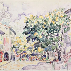
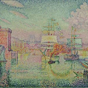
> Paul Signac
> Fine Art Finder
> America & American Art (+canada)
> Fine Art Finder
> Artists
> John (after) Cary
> Fine Art Finder
> Artists
> Paul Signac
> Maps and Charts
> Early Maps
> North America
> Canada
> Maps
> North America
> United States of America
> Maps
> North America
> United States of America
> New York
> New York
> Maps
> North America
> United States of America
> New York
> New York
> Sights
> New York Public Library
EDITORS COMMENTS
This print showcases "A new map of the United States of America, from the latest authorities" created by John Cary in 1806. The beautifully colored engraving, housed at the New York Public Library, offers a glimpse into the historical significance and foundations of the United States. The map serves as a visual representation of the American Revolutionary War (1775-1783), also known as the American War of Independence. It depicts thirteen former North American colonies that had declared themselves independent from Great Britain, forming what would become known as the United States of America. With intricate details and precision, this map highlights not only geographical boundaries but also symbolizes liberty and freedom. It represents a pivotal moment in history when these colonies fought for their independence against British rule. As we explore this remarkable piece, we are transported back to an era filled with warfare and struggle. The image reminds us of the sacrifices made by those who fought for their rights and paved the way for future generations. Through its artistry and historical context, this print invites us to reflect on our nation's past while appreciating how far we have come since those revolutionary times. It is a testament to our enduring spirit and unwavering pursuit of liberty – values that continue to shape America today.
MADE IN THE UK
Safe Shipping with 30 Day Money Back Guarantee
FREE PERSONALISATION*
We are proud to offer a range of customisation features including Personalised Captions, Color Filters and Picture Zoom Tools
SECURE PAYMENTS
We happily accept a wide range of payment options so you can pay for the things you need in the way that is most convenient for you
* Options may vary by product and licensing agreement. Zoomed Pictures can be adjusted in the Basket.