Home > Maps and Charts > World
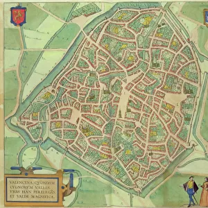
Maps of York, Shrewsbury, Lancaster, and Richmond, from Civitates Orbis Terrarum

![]()
Wall Art and Photo Gifts from Fine Art Finder
Maps of York, Shrewsbury, Lancaster, and Richmond, from Civitates Orbis Terrarum
STC138925 Maps of York, Shrewsbury, Lancaster, and Richmond, from Civitates Orbis Terrarum by Georg Braun (1541-1622) and Frans Hogenberg (1535-90) c.1572-1617 (coloured engraving) by Hoefnagel, Joris (1542-1600) (after); Private Collection; The Stapleton Collection; Flemish, out of copyright
Media ID 23354712
© The Stapleton Collection / Bridgeman Images
Atlas Birds Eye View Cities Of The World English Architecture
FEATURES IN THESE COLLECTIONS
> Architecture
> Palaces
> Arts
> Artists
> Related Images
> Fine Art Finder
> Artists
> Joris (after) Hoefnagel
> Fine Art Finder
> Maps (celestial & Terrestrial)
> Maps and Charts
> World
EDITORS COMMENTS
This print showcases the exquisite "Maps of York, Shrewsbury, Lancaster, and Richmond" from the renowned Civitates Orbis Terrarum collection. Created by Georg Braun and Frans Hogenberg between 1572 and 1617, these beautifully colored engravings offer a fascinating glimpse into the English cities of the 16th century. The intricate details captured in this image transport us back in time as we explore the rich tapestry of architecture, culture, and history that defined these remarkable urban centers. From towering palaces to charming streets lined with period costumes, every element within these maps tells a story waiting to be discovered. As our eyes wander across each city's bird's-eye view layout meticulously crafted by Joris Hoefnagel after Braun and Hogenberg's original designs, we are transported into an era where exploration was at its peak. The sheer magnitude of information contained within these maps is awe-inspiring; they serve not only as navigational tools but also as works of art that capture the essence of their respective locations. Whether you are an avid historian or simply appreciate fine craftsmanship, this print allows you to immerse yourself in a world long gone but forever preserved through art. As part of The Stapleton Collection housed in a private collection today, it serves as a testament to the enduring legacy left behind by those who sought to document our ever-evolving world for generations to come.
MADE IN THE UK
Safe Shipping with 30 Day Money Back Guarantee
FREE PERSONALISATION*
We are proud to offer a range of customisation features including Personalised Captions, Color Filters and Picture Zoom Tools
SECURE PAYMENTS
We happily accept a wide range of payment options so you can pay for the things you need in the way that is most convenient for you
* Options may vary by product and licensing agreement. Zoomed Pictures can be adjusted in the Basket.