Home > Arts > Artists > V > Jules Verne
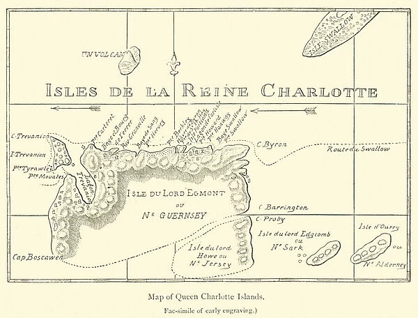
Map of Queen Charlotte Islands (engraving)
![]()

Wall Art and Photo Gifts from Fine Art Finder
Map of Queen Charlotte Islands (engraving)
2781470 Map of Queen Charlotte Islands (engraving) by French School, (19th century); Private Collection; (add.info.: Map of Queen Charlotte Islands. Illustration for The Great Navigators of the Eighteenth Century by Jules Verne (Sampson Low, 1880).); © Look and Learn
Media ID 22424096
© Look and Learn / Bridgeman Images
Explorers Geographical Navigation Navigator Navigators Queen Charlotte Islands
FEATURES IN THESE COLLECTIONS
> Animals
> Mammals
> Soricidae
> Navigator
> Arts
> Artists
> V
> Jules Verne
> Fine Art Finder
> Artists
> French School
> Maps and Charts
> Related Images
EDITORS COMMENTS
This print showcases a remarkable engraving of the Map of Queen Charlotte Islands, created by the French School in the 19th century. This historical piece is part of a private collection and was originally featured as an illustration for Jules Verne's renowned book, "The Great Navigators of the Eighteenth Century" (Sampson Low, 1880). With its intricate details and exquisite craftsmanship, this map takes us on a journey back in time to an era of navigators and discovery. It offers a glimpse into the geographical wonders and uncharted territories that fascinated explorers during this period. The Queen Charlotte Islands, known today as Haida Gwaii, were undoubtedly one of these alluring destinations for intrepid adventurers. The map not only serves as a testament to their exploration but also highlights the importance of geography in guiding these brave souls through unexplored waters. As we gaze upon this print, we are transported to an age when navigation relied heavily on maps like these - meticulously crafted tools that enabled explorers to chart new courses across vast oceans. It reminds us of the courage and determination exhibited by those who dared to venture into unknown lands. Bridgeman Images has beautifully captured this significant piece from Fine Art Finder's collection, allowing us to appreciate both its historical value and artistic brilliance.
MADE IN THE UK
Safe Shipping with 30 Day Money Back Guarantee
FREE PERSONALISATION*
We are proud to offer a range of customisation features including Personalised Captions, Color Filters and Picture Zoom Tools
SECURE PAYMENTS
We happily accept a wide range of payment options so you can pay for the things you need in the way that is most convenient for you
* Options may vary by product and licensing agreement. Zoomed Pictures can be adjusted in the Basket.


