Home > Europe > United Kingdom > England > London > Art > Venues > The Royal Chelsea Hospital
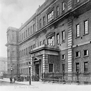
Map of the Royal Hospital, Chelsea, 1900 (b/w photo)
")
![]()
Wall Art and Photo Gifts from Fine Art Finder
Map of the Royal Hospital, Chelsea, 1900 (b/w photo)
8626987 Map of the Royal Hospital, Chelsea, 1900 (b/w photo) by English School, (19th century); Private Collection; (add.info.: Map of the Royal Hospital, Chelsea, 1900. Illustration for An Illustrated HIstorical Handbook to the Parish of Chelsea by Reginald Blunt (Lamley, 1900).); © Look and Learn
Media ID 38290242
© © Look and Learn / Bridgeman Images
Stratagem Strategy Veteran Veterans War Veteran War Veterans
FEATURES IN THESE COLLECTIONS
> Arts
> Artists
> I
> Irish School Irish School
> Europe
> Republic of Ireland
> Maps
> Europe
> United Kingdom
> England
> London
> Art
> Venues
> The Royal Chelsea Hospital
> Europe
> United Kingdom
> England
> London
> Boroughs
> Kensington and Chelsea
> Europe
> United Kingdom
> England
> London
> Hospitals
> Europe
> United Kingdom
> England
> London
> Royalty
> Europe
> United Kingdom
> England
> London
> Towns
> Chelsea
> Europe
> United Kingdom
> England
> Maps
> Europe
> United Kingdom
> Maps
> Europe
> United Kingdom
> Northern Ireland
> Maps
> Fine Art Finder
> Artists
> English School
EDITORS COMMENTS
This print of the Map of the Royal Hospital, Chelsea from 1900 offers a fascinating glimpse into the history of this iconic institution. The intricate details captured in this image showcase the layout and design of the hospital grounds during that time period.
The map itself is a work of art, with its carefully drawn lines and labels indicating various buildings, gardens, and pathways within the hospital complex. It serves as both a practical guide for navigation and a historical record of how the site was organized over a century ago.
Created by an English School artist in the 19th century, this map was originally featured in An Illustrated Historical Handbook to the Parish of Chelsea by Reginald Blunt. Its inclusion in this publication speaks to its significance as a valuable resource for understanding the architectural heritage of Chelsea.
As we study this map today, we are transported back to a different era when horse-drawn carriages traversed cobblestone streets and soldiers roamed these hallowed grounds. It reminds us of the rich history embedded in every corner of our cities, waiting to be rediscovered through images like these preserved by institutions such as Fine Art Finder.
MADE IN THE UK
Safe Shipping with 30 Day Money Back Guarantee
FREE PERSONALISATION*
We are proud to offer a range of customisation features including Personalised Captions, Color Filters and Picture Zoom Tools
SECURE PAYMENTS
We happily accept a wide range of payment options so you can pay for the things you need in the way that is most convenient for you
* Options may vary by product and licensing agreement. Zoomed Pictures can be adjusted in the Basket.