Home > Arts > Artists > O > Abraham Ortelius
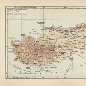
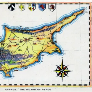
Map of Asia Minor (Istanbul and Turkey with the islands of Rhodes and Cyprus)
")
![]()
Wall Art and Photo Gifts from Fine Art Finder
Map of Asia Minor (Istanbul and Turkey with the islands of Rhodes and Cyprus)
LRI4705006 Map of Asia Minor (Istanbul and Turkey with the islands of Rhodes and Cyprus), 1570 (engraving) by Ortelius, Abraham (1527-98); Museo Navale di Pegli, Genoa, Italy; (add.info.: Natoliae, Quae Olim Asia Minor Nova Descriptio Geography map of the territory of Asia Minor (Istanbul and Turkey with the islands of Rhodes and Cyprus) from " Theatrum Orbis Terrarum" by Abraham Ortelius (Oertel, Ortell or Ortel, 1527-1598), 1570. Genova, Museo Navale); Luisa Ricciarini; Flemish, out of copyright
Media ID 23329554
© Luisa Ricciarini / Bridgeman Images
Atlas Book Chypre Geographical Map Rhodes Grece Turk
FEATURES IN THESE COLLECTIONS
> Arts
> Artists
> O
> Abraham Ortelius
> Asia
> Cyprus
> Related Images
> Europe
> Italy
> Liguria
> Genoa
> Fine Art Finder
> Artists
> Abraham Ortelius
> Maps and Charts
> Abraham Ortelius
> Maps and Charts
> Italy
EDITORS COMMENTS
This print showcases a historic map of Asia Minor, specifically Istanbul and Turkey, along with the islands of Rhodes and Cyprus. Created by Abraham Ortelius in 1570, this engraving is part of his renowned work "Theatrum Orbis Terrarum". The intricate details and precision displayed in this map highlight Ortelius' expertise as a cartographer. The Map of Asia Minor offers a glimpse into the geographical landscape during that era. It provides valuable insights into the region's political boundaries, topography, and major cities. This particular piece also includes annotations in Greek, emphasizing its relevance to both Turkish and Greek history. Displayed at the Museo Navale di Pegli in Genoa, Italy, this artwork serves as a testament to Ortelius' contribution to cartography. Its inclusion within their collection signifies its historical significance and artistic value. Luisa Ricciarini beautifully captures this remarkable print through her lens. Her attention to detail allows viewers to appreciate every intricacy present on the map while preserving its essence for generations to come. As we explore this image further, we are reminded of how maps like these have shaped our understanding of different regions throughout time. They serve not only as navigational tools but also as windows into our past – connecting us with ancient civilizations and providing invaluable knowledge about our world's rich history.
MADE IN THE UK
Safe Shipping with 30 Day Money Back Guarantee
FREE PERSONALISATION*
We are proud to offer a range of customisation features including Personalised Captions, Color Filters and Picture Zoom Tools
SECURE PAYMENTS
We happily accept a wide range of payment options so you can pay for the things you need in the way that is most convenient for you
* Options may vary by product and licensing agreement. Zoomed Pictures can be adjusted in the Basket.