Fraud Blocker Skip to main content

Home > Maps and Charts > Cyprus

Cyprus Collection

Cyprus is an island country located in the eastern Mediterranean Sea

Choose a picture from our Cyprus Collection for your Wall Art and Photo Gifts

114 items

Background imageCyprus Collection: Map of Cyprus, published in 1880

Map of Cyprus, published in 1880
Ancient map of Cyprus. Lithograph, published in 1880

Background imageCyprus Collection: Antique map of the Middle East with Egypt, Syria, and Israel

Antique map of the Middle East with Egypt, Syria, and Israel. Date unknown

Background imageCyprus Collection: Map of Cyprus - The Island of Venus

Map of Cyprus - The Island of Venus. circa 1930s

Background imageCyprus Collection: Map of The Byzantine Empire

Map of The Byzantine Empire
A map showing the extent of the Byzantine Empire - the predominantly Greek-speaking continuation of the Roman Empire during Late Antiquity and the Middle Ages. Date: 1800

Background imageCyprus Collection: Apostle Pauls Missionary Journeys, lithograph, published in 1886

Apostle Pauls Missionary Journeys, lithograph, published in 1886
Apostle Pauls Missionary Journeys: 1st (green); 2nd (red); 3rd (blue); last to Rome (yellow). Lithograph, published in 1886. Paul travelled over 10, 000 miles proclaiming the gospel of Jesus Christ

Background imageCyprus Collection: Map of Cyprus

Map of Cyprus
Vintage 19th Century map of Cyprus in the eastern Mediterranean Sea

Background imageCyprus Collection: Homeric cosmogony

Homeric cosmogony. Map of the Earth based on the myths and knowledge of the Ancient Greeks at the time of Homer (1st or 2nd millennium BC)

Background imageCyprus Collection: Tower Hamlets E2 0 Map

Tower Hamlets E2 0 Map
Postcode Sector Map of Tower Hamlets E2 0

Background imageCyprus Collection: Ottoman Empire, lithograph, published in 1878

Ottoman Empire, lithograph, published in 1878
Ancient map of Ottoman Empire. Lithograph, published in 1878

Background imageCyprus Collection: Antique map of holy land including Syria and Lebanon

Antique map of holy land including Syria and Lebanon

Background imageCyprus Collection: Panoramic map of Mediterranean by G. H. Davis

Panoramic map of Mediterranean by G. H. Davis
A new centre of world alarm during the Second World War: a panoramic map of the Mediterranean, showing the principal bases

Background imageCyprus Collection: Strategic importance of Crete and Cyprus by G. H. Davis

Strategic importance of Crete and Cyprus by G. H. Davis
The Eastern Mediterranean: maps showing the strategic importance of Crete and Cyprus during the Second World War. Date: 1941

Background imageCyprus Collection: Antique map of Asia Minor

Antique map of Asia Minor

Background imageCyprus Collection: Primary cities of Europe, their population and degree of trade of individual states (print)

Primary cities of Europe, their population and degree of trade of individual states (print)
6202957 Primary cities of Europe, their population and degree of trade of individual states (print; (add.info.: CARTOGRAPHY "Primary cities of Europe)

Background imageCyprus Collection: The Ottoman Empire: Saudi Arabia, Greece, Egypt, Cyprus, Lebanon, Syria, Anatolia

The Ottoman Empire: Saudi Arabia, Greece, Egypt, Cyprus, Lebanon, Syria, Anatolia
JEB4874587 The Ottoman Empire: Saudi Arabia, Greece, Egypt, Cyprus, Lebanon, Syria, Anatolia... map of Nicolas and William Sanson of Abbevile. Municipal library of Marseille

Background imageCyprus Collection: Map of Third Crusade and Childrens Crusade

Map of Third Crusade and Childrens Crusade
Map of the Third Crusade and the Childrens Crusade, showing various routes and territories. Date: 1190

Background imageCyprus Collection: Old topographic map of Asia Minor (Turkey), lithograph, published 1897

Old topographic map of Asia Minor (Turkey), lithograph, published 1897
Old topographic map of Asia Minor (Turkey). Lithograph, published 1897

Background imageCyprus Collection: Middle East Ancient Map, Garden of Eden, 1675

Middle East Ancient Map, Garden of Eden, 1675
This may appear to be a straightforward map of the Middle East. However, closer inspection will reveal some extraordinary details, a number of descriptions on the map refer to stories from the Bible

Background imageCyprus Collection: Cyprus map - Published 1884 by William Mackenzie, London for 'The National Encyclopedia'

Cyprus map - Published 1884 by William Mackenzie, London for "The National Encyclopedia"

Background imageCyprus Collection: Wakefield WF1 3 Map

Wakefield WF1 3 Map
Postcode Sector Map of Wakefield WF1 3

Background imageCyprus Collection: Wakefield WF1 2 Map

Wakefield WF1 2 Map
Postcode Sector Map of Wakefield WF1 2

Background imageCyprus Collection: Gedling NG3 5 Map

Gedling NG3 5 Map
Postcode Sector Map of Gedling NG3 5

Background imageCyprus Collection: Milton Keynes MK3 5 Map

Milton Keynes MK3 5 Map
Postcode Sector Map of Milton Keynes MK3 5

Background imageCyprus Collection: Leicester LE2 8 Map

Leicester LE2 8 Map
Postcode Sector Map of Leicester LE2 8

Background imageCyprus Collection: Newham E16 2 Map

Newham E16 2 Map
Postcode Sector Map of Newham E16 2

Background imageCyprus Collection: Cambridge CB1 3 Map

Cambridge CB1 3 Map
Postcode Sector Map of Cambridge CB1 3

Background imageCyprus Collection: Blackburn with Darwen BB3 2 Map

Blackburn with Darwen BB3 2 Map
Postcode Sector Map of Blackburn with Darwen BB3 2

Background imageCyprus Collection: Physical Map of the Ottoman Empire, c1915. Creator: Unknown

Physical Map of the Ottoman Empire, c1915. Creator: Unknown
Physical Map of the Ottoman Empire, c1915. Map showing the eastern Mediterranean, Cyprus, the Middle East, the rivers Tigris and Euphrates, what is now Turkey, and part of Egypt

Background imageCyprus Collection: Asia Minor, the Caucasus Region and Mesopotamia, First World War, c1915, (c1920)

Asia Minor, the Caucasus Region and Mesopotamia, First World War, c1915, (c1920). Map of part of the Middle East, showing eastern Turkey, Cyprus, Syria, Lebanon, Palestine

Background imageCyprus Collection: Antique map of Persia and Arabia 1730

Antique map of Persia and Arabia 1730
Original antique copper engraved map by H. Moll, titled Persia Sive Shahistana, published in 1747 for the Universal History (London, T. Osborne & J. Shipton, 8 vols. 1747)

Background imageCyprus Collection: 13830048

13830048

Background imageCyprus Collection: Nomikos Lines, Mediterranean Passenger Services

Nomikos Lines, Mediterranean Passenger Services Date: 1955

Background imageCyprus Collection: Map of the Near East in ancient times (coloured engraving)

Map of the Near East in ancient times (coloured engraving)
7148248 Map of the Near East in ancient times (coloured engraving) by Kiepert, Heinrich (1818-99); Private Collection; (add.info.: Map of the Near East in ancient times)

Background imageCyprus Collection: British Possessions in Europe (colour litho)

British Possessions in Europe (colour litho)
7169498 British Possessions in Europe (colour litho) by English School, (20th century); Private Collection; (add.info.: British Possessions in Europe)

Background imageCyprus Collection: Map of the island of Cyprus (cipro) in 1587 in '

Map of the island of Cyprus (cipro) in 1587 in "
XEE4409267 Map of the island of Cyprus (cipro) in 1587 in " Il devotissimo viaggio di Gerusalemme". by Unknown Artist

Background imageCyprus Collection: Plan of Cagliari (Calaris), Sardinia (Italy), Malta (Malta)

Plan of Cagliari (Calaris), Sardinia (Italy), Malta (Malta)
LRI4708517 Plan of Cagliari (Calaris), Sardinia (Italy), Malta (Malta), Rhodes (Rhodus) and Famagusta (Famaugusta), Cyprus (etching, 1572-1617) by Hogenberg

Background imageCyprus Collection: The Island of Cyprus, the Chief Towns, and the Neighbouring Coasts (engraving)

The Island of Cyprus, the Chief Towns, and the Neighbouring Coasts (engraving)
1621810 The Island of Cyprus, the Chief Towns, and the Neighbouring Coasts (engraving) by English School, (19th century); Private Collection; (add.info.: The Island of Cyprus, the Chief Towns)

Background imageCyprus Collection: Map of Sixteenth Century Turkey, from the Sala delle Carte Geografiche

Map of Sixteenth Century Turkey, from the Sala delle Carte Geografiche
BEN90577 Map of Sixteenth Century Turkey, from the Sala delle Carte Geografiche (Hall of Geographical Maps) 1575 (oil on panel) by Bonsignori, Stefano and Danti

Background imageCyprus Collection: Map of Parma, Siena, Palermo, and Drepanum, from Civitates Orbis Terrarum

Map of Parma, Siena, Palermo, and Drepanum, from Civitates Orbis Terrarum
STC121068 Map of Parma, Siena, Palermo, and Drepanum, from Civitates Orbis Terrarum by Georg Braun (1541-1622) and Frans Hogenberg (1535-90), c.1572 (coloured engraving) by Hoefnagel

Background imageCyprus Collection: Map of Asia Minor (Istanbul and Turkey with the islands of Rhodes and Cyprus)

Map of Asia Minor (Istanbul and Turkey with the islands of Rhodes and Cyprus)
LRI4705006 Map of Asia Minor (Istanbul and Turkey with the islands of Rhodes and Cyprus), 1570 (engraving) by Ortelius, Abraham (1527-98); Museo Navale di Pegli, Genoa, Italy; (add.info.: Natoliae)

Background imageCyprus Collection: Cyprus and the Islands Stalimini (Lemnos) Chios, Mitilene, Negroponte

Cyprus and the Islands Stalimini (Lemnos) Chios, Mitilene, Negroponte
LRI4718763 Cyprus and the Islands Stalimini (Lemnos) Chios, Mitilene, Negroponte, Cerigo and Rhodus (engraving, 1596) by Mercator, Gerardus (1512-94); Private Collection; (add.info.: Cyprusins)

Background imageCyprus Collection: Cyprus and Greece Islands (Corfu, Zante, Milo, Santorini, Karpathos) (engraving, 1596)

Cyprus and Greece Islands (Corfu, Zante, Milo, Santorini, Karpathos) (engraving, 1596)
LRI4718552 Cyprus and Greece Islands (Corfu, Zante, Milo, Santorini, Karpathos) (engraving, 1596) by Mercator, Gerardus (1512-94); Private Collection; (add.info)

Background imageCyprus Collection: Turkey - Cyprus (engraving, 1596)

Turkey - Cyprus (engraving, 1596)
LRI4718694 Turkey - Cyprus (engraving, 1596) by Mercator, Gerardus (1512-94); Private Collection; (add.info.: Natoliae sive Asia minor (Asia minor)

Background imageCyprus Collection: Map of Palestine, 1926 (colour litho)

Map of Palestine, 1926 (colour litho)
3482908 Map of Palestine, 1926 (colour litho) by Trietsch, Davis (1870-1935); Private Collection; (add.info.: PalAastina-Wirtschafts-Atlas. Berlin: Orient-Verlag, [1926])

Background imageCyprus Collection: Cyprus, Renaissance map of Europe, Jacopo Russo (after), 1528

Cyprus, Renaissance map of Europe, Jacopo Russo (after), 1528
2910981 Cyprus, Renaissance map of Europe, Jacopo Russo (after), 1528 by Russo, Jacopo (15th century); (add.info.: Renaissance map of Europe, Jacopo Russo, 1528)

Background imageCyprus Collection: Map of Calais, Malta, Rhodes, and Famagusta, from Civitates Orbis Terrarum

Map of Calais, Malta, Rhodes, and Famagusta, from Civitates Orbis Terrarum
STC121058 Map of Calais, Malta, Rhodes, and Famagusta, from Civitates Orbis Terrarum by Georg Braun (1541-1622) and Frans Hogenberg (1535-90), c.1572 (coloured engraving) by Hoefnagel

Background imageCyprus Collection: Map of the Mediterranean islands of Cyprus and Crete in Greece, 1570 (engraving)

Map of the Mediterranean islands of Cyprus and Crete in Greece, 1570 (engraving)
LRI4704810 Map of the Mediterranean islands of Cyprus and Crete in Greece, 1570 (engraving) by Ortelius, Abraham (1527-98); Museo Navale di Pegli, Genoa, Italy; (add.info.: Cyprus Insula - Candia)

Background imageCyprus Collection: Wolverhampton WV2 4 Map

Wolverhampton WV2 4 Map
Postcode Sector Map of Wolverhampton WV2 4


All Professionally Made to Order for Quick Shipping


-

Cyprus Collection

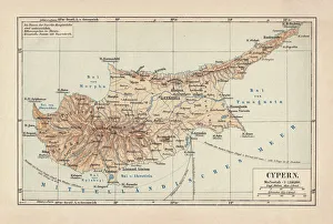
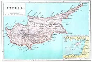
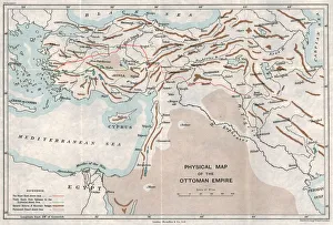
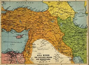
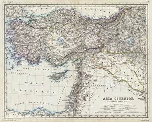
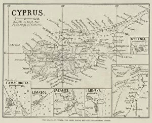
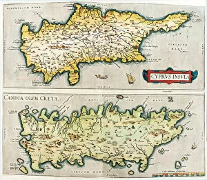
Cyprus is an island country located in the eastern Mediterranean Sea, south of Turkey and west of Syria and Lebanon and has a population of approximately 1.2 million people and its capital city is Nicosia. The official languages are Greek and Turkish, with English widely spoken as well. A rich history dating back to ancient times, with evidence of human settlement from the Neolithic period onwards. The island's economy relies heavily on tourism, shipping, financial services, and agriculture. Its strategic location also makes it an important hub for international trade between Europe, Asia, and Africa.
+

Our beautiful pictures are available as Framed Prints, Photos, Wall Art and Photo Gifts

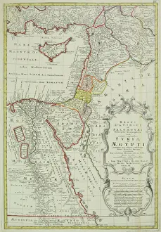
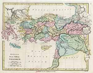
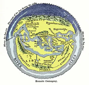
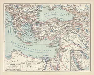
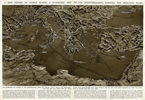
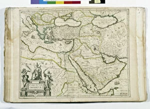
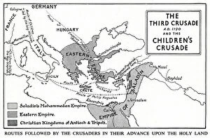
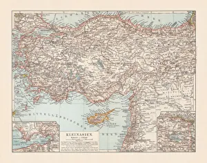
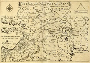
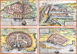
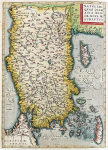
The Cyprus collection from Media Storehouse is a stunning selection of wall art and framed prints that showcase the beauty and history of this Mediterranean island. Our collection features a range of vintage maps, charts, and illustrations that capture the unique geography, architecture, and culture of Cyprus. From detailed topographical maps to colorful tourist guides, each print in our collection offers a fascinating glimpse into the island's past and present. Some highlights include antique engravings depicting ancient ruins, traditional villages, and bustling ports; intricate nautical charts showing coastal landmarks and sea routes; as well as modern satellite images revealing the island's diverse landscapes. Whether you're looking to decorate your home or office with a piece of Cypriot heritage or simply want to explore this enchanting destination from afar, the Cyprus collection has something for everyone. With high-quality printing techniques on premium paper stock, these prints are sure to impress any viewer with their exceptional detail and clarity.
+

What are Cyprus (Maps and Charts) art prints?

Cyprus art prints are high-quality reproductions of vintage maps and charts featuring the island of Cyprus. These prints showcase the intricate details, vibrant colors, and unique features of these historical documents, making them perfect for anyone interested in history or geography. These art prints are created using state-of-the-art printing technology to ensure that every detail is captured accurately. They come in a variety of sizes and can be framed to suit any decor style. Whether you're looking for a piece to add to your home or office, or as a gift for someone special, Cyprus art prints offer an excellent way to bring history into your space. With their timeless appeal, these art prints are sure to become treasured pieces that will be enjoyed by generations to come. So if you're looking for something unique and beautiful that celebrates the rich history of Cyprus, look no further than our collection of Cyprus art prints.
+

What Cyprus (Maps and Charts) art prints can I buy from Media Storehouse?

We offer a wide range of Cyprus art prints that are perfect for anyone looking to add some beautiful and unique artwork to their home or office. These prints include maps and charts that showcase the stunning geography of this Mediterranean island nation, including detailed topographical maps, historical maps, and nautical charts. Whether you're interested in exploring the ancient ruins of Paphos or admiring the crystal-clear waters of Ayia Napa, we have a print that will capture your imagination. You can choose from a variety of sizes and formats to suit your needs, whether you want a small print for your desk or a large canvas to hang on your wall. With high-quality printing technology and premium materials, these Cyprus art prints are sure to impress. They make great gifts for anyone who loves travel, history, or beautiful landscapes. So why not explore our collection today?
+

How do I buy Cyprus (Maps and Charts) art prints?

To purchase Cyprus art prints from Media Storehouse, you can browse our extensive collection of high-quality images online. Simply search for "Cyprus Maps and Charts" in the search bar on our website to view all available options. Once you have found a print that you like, select the size and format that suits your needs. We offer a range of sizes and formats including framed prints, canvas prints, and photographic prints. You can also choose to have your print delivered rolled or flat depending on your preference. To complete your purchase, simply add the item to your cart and proceed to checkout. You will be prompted to enter your shipping information as well as payment details before finalizing the order. Whether you are looking for a unique piece of wall art for your home or office or searching for a special gift for someone who loves Cyprus history or geography, we have plenty of options to choose from.
+

How much do Cyprus (Maps and Charts) art prints cost?

We offer a wide range of Cyprus maps and charts art prints that are perfect for anyone who loves the beauty and history of this Mediterranean island. Our collection includes a variety of styles and sizes to suit any taste or budget, from vintage maps to modern illustrations. While we cannot provide specific pricing information in this response, we can assure you that our prices are competitive and affordable. We strive to make high-quality art accessible to everyone, so you can enjoy beautiful Cyprus artwork without breaking the bank. Whether you're looking for a unique piece to decorate your home or office, or searching for a thoughtful gift for someone special, our Cyprus maps and charts art prints are sure to impress. With fast shipping and easy ordering options available through our website, it's never been easier to add some Cypriot charm to your life.
+

How will my Cyprus (Maps and Charts) art prints be delivered to me?

We take great care in ensuring that your Cyprus art prints are delivered to you safely and securely. We use high-quality packaging materials to protect your print during transit, including sturdy cardboard tubes for rolled prints and strong flat-pack boxes for mounted or framed prints. All of our deliveries are fully tracked, so you can monitor the progress of your order from dispatch to delivery. Our courier partners are trusted professionals who will handle your package with care and deliver it directly to your door. We understand how important it is for you to receive your artwork in perfect condition, which is why we take every precaution possible when packing and shipping your order. Whether you're ordering a single print or multiple items, rest assured that we'll do everything we can to ensure that they arrive at their destination in pristine condition.