Canvas Print > Europe > United Kingdom > England > London > Sights > St James Park
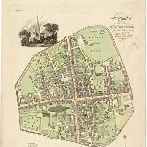
Canvas Print : Map Of Chichester, 1812


![]()
Canvas Prints from West Sussex County Council
Map Of Chichester, 1812
Map includes area outside of the city walls. Plan of the liberties of the City of Chichester from an actual survey taken April 1812 by George Loader, Surveyor
Printed Maps Collection
West Sussex Record Office Ref No: PM 10
West Sussex County Council Record Office contains a fascinating history of the county of West Sussex, England
Media ID 5978151
Oaklands Park Barracks South Gate Spitalfields St James St Pancras West Gate
20"x16" (50x40cm) Canvas Print
Discover the rich history of Chichester with our stunning Canvas Print of the "Map of Chichester, 1812" from West Sussex County Council. This beautiful piece showcases an intricately detailed plan of the city and its liberties, as surveyed by George Loader in April 1812. The map includes the area outside of the city walls, providing a comprehensive view of the layout of Chichester during this historical period. Bring the past into your home or office with this captivating and authentic work of art. Order your Canvas Print today and enjoy the timeless beauty of this piece for years to come.
Ready to hang Premium Gloss Canvas Print. Our archival quality canvas prints are made from Polyester and Cotton mix and stretched over a 1.25" (32mm) kiln dried knot free wood stretcher bar. Packaged in a plastic bag and secured to a cardboard insert for transit.
Canvas Prints add colour, depth and texture to any space. Professionally Stretched Canvas over a hidden Wooden Box Frame and Ready to Hang
Estimated Product Size is 40.6cm x 50.8cm (16" x 20")
These are individually made so all sizes are approximate
Artwork printed orientated as per the preview above, with portrait (vertical) orientation to match the source image.
FEATURES IN THESE COLLECTIONS
> Arts
> Landscape paintings
> Waterfall and river artworks
> River artworks
> Europe
> United Kingdom
> England
> London
> Sights
> St James Park
> Europe
> United Kingdom
> England
> Sussex
> Chichester
> Europe
> United Kingdom
> England
> Sussex
> Related Images
> Europe
> United Kingdom
> England
> Sussex
> River
> Europe
> United Kingdom
> England
> West Sussex
> Chichester
> Europe
> United Kingdom
> England
> West Sussex
> Related Images
> Maps and Charts
> Related Images
> West Sussex County Council
> Urban
> West Sussex County Council
> West Sussex Record Office
> Printed Maps
EDITORS COMMENTS
This print showcases a beautifully detailed Map of Chichester from the year 1812. The map, created by the skilled surveyor George Loader, goes beyond the city walls and provides an extensive plan of the liberties surrounding the City of Chichester. With its vibrant colors and intricate design, this historical map offers a fascinating glimpse into the past. It highlights significant landmarks such as St James, South Gate, St Pancras, Spitalfields, West Gate, Barracks, The Broyle, River Lavant, Oaklands Park, and The Hornet. Preserved in West Sussex Record Office's Printed Maps Collection under reference number PM 10), this remarkable piece serves as a valuable resource for historians and enthusiasts alike. Its accuracy is owed to Loader's meticulous survey taken in April 1812. As you explore this image print further with your eyes tracing every street and landmark depicted on it; you can't help but feel transported back in time to early 19th-century Chichester. This visual representation allows us to appreciate how much has changed over two centuries while also recognizing that some elements have remained constant
MADE IN THE UK
Safe Shipping with 30 Day Money Back Guarantee
FREE PERSONALISATION*
We are proud to offer a range of customisation features including Personalised Captions, Color Filters and Picture Zoom Tools
SECURE PAYMENTS
We happily accept a wide range of payment options so you can pay for the things you need in the way that is most convenient for you
* Options may vary by product and licensing agreement. Zoomed Pictures can be adjusted in the Basket.


![Royal Engineers bomb disposal team at work, [Mar 1941]](/sq/479/royal-engineers-bomb-disposal-team-work-8359434.jpg.webp)
![Chichester St. Peter the Great [Subdeanery] tithe map, 1846-1847](/sq/479/chichester-st-peter-great-subdeanery-tithe-10701869.jpg.webp)