Antique Framed Print > Europe > United Kingdom > England > London > Sights > St James Park
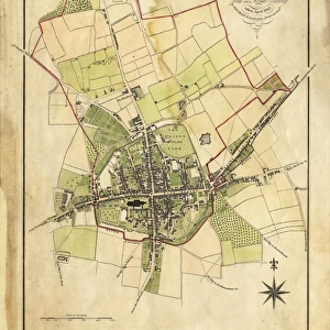
Antique Framed Print : Map Of Chichester, 1812


![]()
Framed Photos from West Sussex County Council
Map Of Chichester, 1812
Map includes area outside of the city walls. Plan of the liberties of the City of Chichester from an actual survey taken April 1812 by George Loader, Surveyor
Printed Maps Collection
West Sussex Record Office Ref No: PM 10
West Sussex County Council Record Office contains a fascinating history of the county of West Sussex, England
Media ID 5978151
Oaklands Park Barracks South Gate Spitalfields St James St Pancras West Gate
14"x12" (36x31cm) Antique Frame
Bevelled wood effect frame, card mounted, 10x8 archival quality photo print. Overall outside dimensions 14x12 inches (36x31cm). Environmentally and ozone friendly, the Polycore® moulding has the look of real wood, is durable and light and easy to hang. Biodegradable and made with non-chlorinated gases (no toxic fumes) it is efficient; producing 100 tons of polystyrene can save 300 tons of trees! Prints are glazed with lightweight, shatterproof, optical clarity acrylic (providing the same general protection from the environment as glass). The back is stapled hardboard with a sawtooth hanger attached. Note: To minimise original artwork cropping, for optimum layout, and to ensure print is secure, the visible print may be marginally smaller
Bevelled Wood Effect Framed and Mounted Prints - Professionally Made and Ready to Hang
Estimated Image Size (if not cropped) is 18.6cm x 24.4cm (7.3" x 9.6")
Estimated Product Size is 31.2cm x 36.3cm (12.3" x 14.3")
These are individually made so all sizes are approximate
Artwork printed orientated as per the preview above, with portrait (vertical) orientation to match the source image.
FEATURES IN THESE COLLECTIONS
> Arts
> Landscape paintings
> Waterfall and river artworks
> River artworks
> Europe
> United Kingdom
> England
> London
> Sights
> St James Park
> Europe
> United Kingdom
> England
> Sussex
> Chichester
> Europe
> United Kingdom
> England
> Sussex
> Related Images
> Europe
> United Kingdom
> England
> Sussex
> River
> Europe
> United Kingdom
> England
> West Sussex
> Chichester
> Europe
> United Kingdom
> England
> West Sussex
> Related Images
> Maps and Charts
> Related Images
> West Sussex County Council
> Urban
> West Sussex County Council
> West Sussex Record Office
> Printed Maps
EDITORS COMMENTS
This print showcases a beautifully detailed Map of Chichester from the year 1812. The map, created by the skilled surveyor George Loader, goes beyond the city walls and provides an extensive plan of the liberties surrounding the City of Chichester. With its vibrant colors and intricate design, this historical map offers a fascinating glimpse into the past. It highlights significant landmarks such as St James, South Gate, St Pancras, Spitalfields, West Gate, Barracks, The Broyle, River Lavant, Oaklands Park, and The Hornet. Preserved in West Sussex Record Office's Printed Maps Collection under reference number PM 10), this remarkable piece serves as a valuable resource for historians and enthusiasts alike. Its accuracy is owed to Loader's meticulous survey taken in April 1812. As you explore this image print further with your eyes tracing every street and landmark depicted on it; you can't help but feel transported back in time to early 19th-century Chichester. This visual representation allows us to appreciate how much has changed over two centuries while also recognizing that some elements have remained constant
MADE IN THE UK
Safe Shipping with 30 Day Money Back Guarantee
FREE PERSONALISATION*
We are proud to offer a range of customisation features including Personalised Captions, Color Filters and Picture Zoom Tools
SECURE PAYMENTS
We happily accept a wide range of payment options so you can pay for the things you need in the way that is most convenient for you
* Options may vary by product and licensing agreement. Zoomed Pictures can be adjusted in the Basket.


![Royal Engineers bomb disposal team at work, [Mar 1941]](/sq/479/royal-engineers-bomb-disposal-team-work-8359434.jpg.webp)
![Chichester St. Peter the Great [Subdeanery] tithe map, 1846-1847](/sq/479/chichester-st-peter-great-subdeanery-tithe-10701869.jpg.webp)