Canvas Print > Sheffield City Archives > Maps and Plans > Maps of Yorkshire
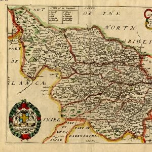
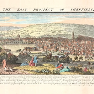
Canvas Print : West Riding of Yorkshire, 1607


![]()
Canvas Prints from Sheffield City Archives
West Riding of Yorkshire, 1607
Full title: Eboracensis comitavis pars Occidentalis vilgo, West Riding.
By Christopher Saxton and William Hole.
Scale 10 miles : 2 inches.
From an original at Sheffield Libraries: y09432
Sheffield City Archives and Local Studies Library has an unrivalled collection of images of Sheffield, England
Media ID 14047385
© Sheffield City Council
20"x16" (50x40cm) Canvas Print
Step back in time with Media Storehouse's Canvas Prints and bring the history of West Riding of Yorkshire to your home. This exquisite print, titled "Eboracensis comitatis pars Occidentalis villo, West Riding," dates back to 1607 and is a rare find from Sheffield City Archives. Originally created by Christopher Saxton and William Hole, this detailed map showcases the West Riding region with a scale of 10 miles to 2 inches. Our high-quality canvas prints are not only a beautiful addition to any room but also a conversation starter, allowing you to share the rich history of this fascinating region with your guests. Order now and travel back in time with every glance.
Ready to hang Premium Gloss Canvas Print. Our archival quality canvas prints are made from Polyester and Cotton mix and stretched over a 1.25" (32mm) kiln dried knot free wood stretcher bar. Packaged in a plastic bag and secured to a cardboard insert for transit.
Canvas Prints add colour, depth and texture to any space. Professionally Stretched Canvas over a hidden Wooden Box Frame and Ready to Hang
Estimated Product Size is 50.8cm x 40.6cm (20" x 16")
These are individually made so all sizes are approximate
Artwork printed orientated as per the preview above, with landscape (horizontal) orientation to match the source image.
EDITORS COMMENTS
This print showcases the historic West Riding of Yorkshire in all its glory, dating back to the year 1607. The full title, "Eboracensis comitavis pars Occidentalis vilgo, West Riding" emphasizes the significance and grandeur of this region during that era. Crafted by Christopher Saxton and William Hole, two renowned cartographers of their time, this map offers a remarkable insight into the geographical layout and topography of West Riding. With a scale of 10 miles to 2 inches, every intricate detail has been meticulously captured on this print. From sprawling landscapes to winding rivers and charming towns, it is as if one can embark on a journey through time simply by gazing at this masterpiece. Preserved with utmost care at Sheffield Libraries under reference y09432, this original piece holds immense historical value for both scholars and enthusiasts alike. The sheer beauty and accuracy depicted in this photograph truly transport us back centuries ago when life unfolded at a different pace. It serves as a testament to the rich heritage embedded within Yorkshire's landscape—a reminder that history continues to shape our present-day surroundings. As we admire this image from Sheffield City Archives, let us appreciate not only its aesthetic appeal but also acknowledge the invaluable role played by libraries in preserving such treasures for generations to come.
MADE IN THE UK
Safe Shipping with 30 Day Money Back Guarantee
FREE PERSONALISATION*
We are proud to offer a range of customisation features including Personalised Captions, Color Filters and Picture Zoom Tools
SECURE PAYMENTS
We happily accept a wide range of payment options so you can pay for the things you need in the way that is most convenient for you
* Options may vary by product and licensing agreement. Zoomed Pictures can be adjusted in the Basket.