Canvas Print > Europe > United Kingdom > England > Yorkshire > Cadeby
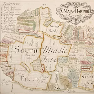
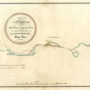
Canvas Print : River Don, between Mexborough and Doncaster, 1803


![]()
Canvas Prints from Sheffield City Archives
River Don, between Mexborough and Doncaster, 1803
Full title: Plan of alterations and improvements to be made in the navigation of the River Dun [between Mexborough and Doncaster, Yorkshire, 1803
By W. and J. Fairbank.
Scale 2 furlongs : 1 inch.
Dimensions of original approx. 20.5 x 37.5 cm.
From an original at Sheffield Libraries: arc02907
Sheffield City Archives and Local Studies Library has an unrivalled collection of images of Sheffield, England
Media ID 19191536
© Sheffield City Council
Doncaster River Don Rivers Yorkshire Mexborough Water Power
21"x14" (53x35cm) Canvas Print
Introducing the Media Storehouse Canvas Print of "River Don, between Mexborough and Doncaster, 1803" from Sheffield City Archives. This captivating historical print showcases the River Don as it appeared over 200 years ago, during the planning stages for navigational improvements between Mexborough and Doncaster. Meticulously reproduced on premium canvas, each print boasts vibrant colors and exceptional detail, bringing history to life in your home or office. Immerse yourself in the rich heritage of Yorkshire with this stunning, museum-quality piece.
Ready to hang Premium Gloss Canvas Print. Our archival quality canvas prints are made from Polyester and Cotton mix and stretched over a 1.25" (32mm) kiln dried knot free wood stretcher bar. Packaged in a plastic bag and secured to a cardboard insert for transit.
Canvas Prints add colour, depth and texture to any space. Professionally Stretched Canvas over a hidden Wooden Box Frame and Ready to Hang
Estimated Product Size is 53.3cm x 35.6cm (21" x 14")
These are individually made so all sizes are approximate
Artwork printed orientated as per the preview above, with landscape (horizontal) orientation to match the source image.
FEATURES IN THESE COLLECTIONS
> Europe
> United Kingdom
> England
> Yorkshire
> Cadeby
> Europe
> United Kingdom
> England
> Yorkshire
> Doncaster
> Europe
> United Kingdom
> England
> Yorkshire
> Mexborough
> Europe
> United Kingdom
> England
> Yorkshire
> Related Images
> Europe
> United Kingdom
> England
> Yorkshire
> Sheffield
> Sheffield City Archives
> Maps and Plans
> Maps of Yorkshire
EDITORS COMMENTS
This print from Sheffield City Archives takes us back to the year 1803, offering a glimpse into the past and shedding light on the remarkable alterations and improvements made in the navigation of River Don. The full title of this historical gem is "Plan of alterations and improvements to be made in the navigation of the River Dun between Mexborough and Doncaster, Yorkshire, 1803" by W. and J. Fairbank. The image showcases a meticulously detailed plan that outlines these modifications along with various landmarks that dotted the river's course during that time. With a scale of 2 furlongs to 1 inch, this print provides an accurate representation of how things were back then. As we delve deeper into this visual treasure trove, we can spot significant features such as Cadeby Common Water Transport and Cadeby Mill which played vital roles in utilizing water power for industrial purposes. Sprotbrough also finds its place on this map, highlighting its importance as part of River Don's history. Doncaster Mill stands tall as another prominent landmark depicted here, reminding us of its significance within Yorkshire's bustling landscape centuries ago. Preserved at Sheffield Libraries under reference arc02907, this original piece measures approximately 20.5 x 37.5 cm—a testament to its delicate nature yet enduring value for those seeking insights into our rich heritage
MADE IN THE UK
Safe Shipping with 30 Day Money Back Guarantee
FREE PERSONALISATION*
We are proud to offer a range of customisation features including Personalised Captions, Color Filters and Picture Zoom Tools
SECURE PAYMENTS
We happily accept a wide range of payment options so you can pay for the things you need in the way that is most convenient for you
* Options may vary by product and licensing agreement. Zoomed Pictures can be adjusted in the Basket.