Canvas Print > Arts > Landscape paintings > Waterfall and river artworks > River artworks
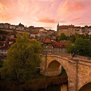
Canvas Print : Fribourg, Switzerland - Map of the City Centre


![]()
Canvas Prints from Mary Evans Picture Library
Fribourg, Switzerland - Map of the City Centre
Fribourg, Switzerland - Map of the City Centre Date: circa 1907
Mary Evans Picture Library makes available wonderful images created for people to enjoy over the centuries
Media ID 18072929
© Mary Evans / Grenville Collins Postcard Collection
Bends Canton Capital Chart Dec17 Freiburg Fribourg Inset Plan Swiss
21"x14" (53x35cm) Canvas Print
Discover the historic charm of Fribourg, Switzerland with our captivating Canvas Print featuring a vintage map of the city center. Immerse yourself in the rich heritage and intricate details showcased in this timeless piece from Mary Evans Prints Online. Perfect for adding a touch of elegance to any space, bring the allure of Fribourg's past into your home or office today.
Ready to hang Premium Gloss Canvas Print. Our archival quality canvas prints are made from Polyester and Cotton mix and stretched over a 1.25" (32mm) kiln dried knot free wood stretcher bar. Packaged in a plastic bag and secured to a cardboard insert for transit.
Canvas Prints add colour, depth and texture to any space. Professionally Stretched Canvas over a hidden Wooden Box Frame and Ready to Hang
Estimated Product Size is 53.3cm x 35.6cm (21" x 14")
These are individually made so all sizes are approximate
Artwork printed orientated as per the preview above, with landscape (horizontal) orientation to match the source image.
FEATURES IN THESE COLLECTIONS
> Arts
> Landscape paintings
> Waterfall and river artworks
> River artworks
> Europe
> Switzerland
> Maps
> Europe
> Switzerland
> Posters
> Europe
> Switzerland
> Railways
> Europe
> Switzerland
> Related Images
> Europe
> Switzerland
> Rivers
> Maps and Charts
> Related Images
> Maps and Charts
> Switzerland
> Popular Themes
> Railway Posters
> Mary Evans Prints Online
> New Images from the Grenville Collins
EDITORS COMMENTS
Step back in time with this map print of Fribourg, Switzerland's city centre, dating back to circa 1907. This intricately detailed chart offers a glimpse into the past, showcasing the layout of the city during the early 1900s. Fribourg, the capital city of the Swiss canton of Fribourg and the district of Freiburg, is nestled at the foot of the Alps and lies along the Sarine River. The map highlights the city's major landmarks, including the historic Old Town, the stunning cathedral, and the winding streets that lead to the railway station. The map's inset view provides a closer look at the city centre, revealing the intricate network of streets and alleys that crisscross the area. The railway line and station are also clearly marked, showcasing the city's connection to the larger railway network that crisscrossed Europe during the early 20th century. The map's charming design, with its delicate lines and meticulous attention to detail, transports us back to a time when travel was an adventure and exploration was a way of life. Whether you're a history buff, a collector of vintage maps, or simply someone who appreciates the beauty of the past, this map print of Fribourg, Switzerland's city centre is a must-have addition to your collection. This map print is a reminder of the rich history and cultural heritage of Fribourg and the surrounding region. It's a window into the past that invites us to explore the stories and secrets that lie hidden within the streets and alleys of this beautiful Swiss city.
MADE IN THE UK
Safe Shipping with 30 Day Money Back Guarantee
FREE PERSONALISATION*
We are proud to offer a range of customisation features including Personalised Captions, Color Filters and Picture Zoom Tools
SECURE PAYMENTS
We happily accept a wide range of payment options so you can pay for the things you need in the way that is most convenient for you
* Options may vary by product and licensing agreement. Zoomed Pictures can be adjusted in the Basket.