Canvas Print > Asia > Armenia > Maps
Canvas Print : Map of Asia Minor (Turkey)
")
")


![]()
Canvas Prints from Mary Evans Picture Library
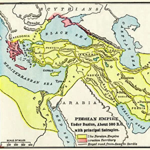
Map of Asia Minor (Turkey)
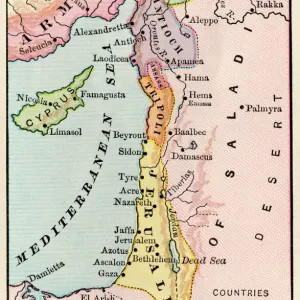
Map of Asia Minor (Turkey) - in antiquity - pre-Ottoman Empire. Date: 1804
Mary Evans Picture Library makes available wonderful images created for people to enjoy over the centuries
Media ID 11575339
© Mary Evans / Grenville Collins Postcard Collection
1804 Anatolia Anatolian Armenia Cappadocia Caria Chart Cilicia Cyprus Ionia Lycia Lydia Maps Mediterranean Minor Mysia Pontus Galatia Paphlagonia
20"x16" (50x40cm) Canvas Print
"Discover the rich history of Asia Minor with our exquisite Canvas Print of the Map of Turkey from 1804, sourced from Mary Evans Prints Online. This captivating Rights Managed image transports you back in time, showcasing the political landscape of Asia Minor before the Ottoman Empire. Perfect for history enthusiasts, world travelers, or those who appreciate the beauty of vintage maps, this Canvas Print adds a touch of sophistication and intrigue to any room. Order now and let this stunning piece of art tell a story of the past."
Ready to hang Premium Gloss Canvas Print. Our archival quality canvas prints are made from Polyester and Cotton mix and stretched over a 1.25" (32mm) kiln dried knot free wood stretcher bar. Packaged in a plastic bag and secured to a cardboard insert for transit.
Canvas Prints add colour, depth and texture to any space. Professionally Stretched Canvas over a hidden Wooden Box Frame and Ready to Hang
Estimated Product Size is 50.8cm x 40.6cm (20" x 16")
These are individually made so all sizes are approximate
Artwork printed orientated as per the preview above, with landscape (horizontal) orientation to match the source image.
FEATURES IN THESE COLLECTIONS
> Asia
> Armenia
> Related Images
> Asia
> Cyprus
> Related Images
> Asia
> Related Images
> Asia
> Turkey
> Related Images
> Europe
> Armenia
> Related Images
EDITORS COMMENTS
This map print, titled 'Map of Asia Minor (Turkey) - in Antiquity - Pre-Ottoman Empire,' transports us back in time to the ancient world of Anatolia, a region that is now modern-day Turkey. Dated 1804, this map offers a fascinating glimpse into the historical geography of Asia Minor before the Ottoman Empire's rise to power. The intricately detailed map is adorned with place names and borders that were once the heart of ancient civilizations. The Black Sea and the Mediterranean Sea frame the map, with the Aegean Sea visible in the southwest. The Asian coastline is marked with various ancient kingdoms and provinces, including Thracia, Phyrigia, Galatia, Cappadocia, Lycia, Caria, Lydia, Mysia, Ionia, Bithynia, Paphlagonia, Pontus, Armenia, Pisidia, Cilicia, and many more. Cyprus, an island nation located in the eastern Mediterranean, is also depicted on the map. The map's key provides valuable information about the various regions, their borders, and the major cities within them. This historical map serves as a testament to the rich cultural heritage of Asia Minor and the ancient civilizations that once thrived there. The map's antiquity adds to its allure, as it offers a unique perspective on the historical geography of a region that continues to be a focal point of global interest today. Whether you're an avid history buff, a geography enthusiast, or simply someone who appreciates the beauty of historical maps, this Map of Asia Minor (Turkey) - in Antiquity - Pre-Ottoman Empire is a must-have addition to your collection.
MADE IN THE UK
Safe Shipping with 30 Day Money Back Guarantee
FREE PERSONALISATION*
We are proud to offer a range of customisation features including Personalised Captions, Color Filters and Picture Zoom Tools
SECURE PAYMENTS
We happily accept a wide range of payment options so you can pay for the things you need in the way that is most convenient for you
* Options may vary by product and licensing agreement. Zoomed Pictures can be adjusted in the Basket.