Canvas Print > Europe > United Kingdom > Scotland > Caithness
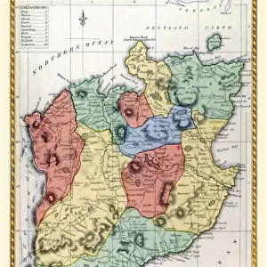
Canvas Print : Old Map of the County of Caithness from the Philips Handy Atlas of 1882


![]()
Canvas Prints from MapSeeker
Old Map of the County of Caithness from the Philips Handy Atlas of 1882
PHA007
Welcome to the Mapseeker Image library and enter an historic gateway to one of the largest on-line collections of Historic Maps, Nostalgic Views, Vista's and Panorama's from a World gone by.
Media ID 20348022
County Map County Map Of Scotland Historic Map Old County Map Old Scottish County Map Scottish County Map Caithness
20"x16" (50x40cm) Canvas Print
Step back in time with our exquisite Canvas Print of the Old Map of Caithness from the Philips Handy Atlas of 1882 (PHA007), available at Media Storehouse. This beautiful, vintage map brings the rich history of Caithness County to your home or office, with intricate details and authentic textures. Each Canvas Print is meticulously crafted using high-quality materials, ensuring vibrant colors and long-lasting durability. Transport yourself to a bygone era and add a unique touch to your decor with this stunning, collectible piece.
Ready to hang Premium Gloss Canvas Print. Our archival quality canvas prints are made from Polyester and Cotton mix and stretched over a 1.25" (32mm) kiln dried knot free wood stretcher bar. Packaged in a plastic bag and secured to a cardboard insert for transit.
Canvas Prints add colour, depth and texture to any space. Professionally Stretched Canvas over a hidden Wooden Box Frame and Ready to Hang
Estimated Product Size is 40.6cm x 50.8cm (16" x 20")
These are individually made so all sizes are approximate
Artwork printed orientated as per the preview above, with portrait (vertical) orientation to match the source image.
FEATURES IN THESE COLLECTIONS
> Europe
> United Kingdom
> Scotland
> Caithness
> Europe
> United Kingdom
> Scotland
> Maps
> Europe
> United Kingdom
> Scotland
> Posters
> Europe
> United Kingdom
> Scotland
> Related Images
> Maps and Charts
> Early Maps
> Maps and Charts
> Related Images
> MapSeeker
> Maps from the British Isles
> Scotland and Counties PORTFOLIO
EDITORS COMMENTS
This print showcases an exquisite piece of history, the "Old Map of the County of Caithness from the Philips Handy Atlas of 1882". Transporting us back in time, this Scottish county map offers a glimpse into the past with its intricate details and rich historical significance. As we explore this old county map, we are taken on a journey through Caithness, a region steeped in heritage and charm. Every contour line and carefully drawn boundary tells a story of centuries gone by. The delicate craftsmanship employed in creating this historic caithness map is evident, capturing our attention and imagination. With its faded hues and aged appearance, this vintage treasure evokes nostalgia for simpler times when maps were meticulously hand-drawn works of art. It serves as a reminder that technology may have transformed how we navigate today's world but cannot diminish the allure of these antique cartographic gems. Whether you are an avid historian or simply appreciate the beauty found within historical artifacts, this old county map will undoubtedly captivate your senses. Its presence adds character to any space while serving as a testament to Scotland's enduring legacy
MADE IN THE UK
Safe Shipping with 30 Day Money Back Guarantee
FREE PERSONALISATION*
We are proud to offer a range of customisation features including Personalised Captions, Color Filters and Picture Zoom Tools
SECURE PAYMENTS
We happily accept a wide range of payment options so you can pay for the things you need in the way that is most convenient for you
* Options may vary by product and licensing agreement. Zoomed Pictures can be adjusted in the Basket.