Canvas Print > Europe > United Kingdom > Scotland > Strathclyde > Ayr
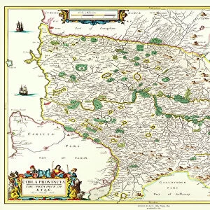
Canvas Print : Old Map of the County of Ayr from the Philips Handy Atlas of 1882


![]()
Canvas Prints from MapSeeker
Old Map of the County of Ayr from the Philips Handy Atlas of 1882
PHA004
Welcome to the Mapseeker Image library and enter an historic gateway to one of the largest on-line collections of Historic Maps, Nostalgic Views, Vista's and Panorama's from a World gone by.
Media ID 20346961
County Map County Map Of Scotland Historic Map Old County Map Old Scottish County Map Scottish County Map Ayrshire
20"x16" (50x40cm) Canvas Print
Step back in time with Media Storehouse's Canvas Print of the Old Map of Ayr County from the Philips Handy Atlas of 1882 (PHA004). This beautiful, vintage map brings history to life, capturing intricate details and landmarks of Ayr County as they appeared over a century ago. Each canvas print is meticulously crafted with high-quality materials, ensuring a stunning visual representation that adds character and charm to any room. Bring a piece of the past into your home or office with this unique and captivating wall art piece.
Ready to hang Premium Gloss Canvas Print. Our archival quality canvas prints are made from Polyester and Cotton mix and stretched over a 1.25" (32mm) kiln dried knot free wood stretcher bar. Packaged in a plastic bag and secured to a cardboard insert for transit.
Canvas Prints add colour, depth and texture to any space. Professionally Stretched Canvas over a hidden Wooden Box Frame and Ready to Hang
Estimated Product Size is 40.6cm x 50.8cm (16" x 20")
These are individually made so all sizes are approximate
Artwork printed orientated as per the preview above, with portrait (vertical) orientation to match the source image.
FEATURES IN THESE COLLECTIONS
> Europe
> United Kingdom
> Scotland
> Ayrshire
> Europe
> United Kingdom
> Scotland
> Maps
> Europe
> United Kingdom
> Scotland
> Posters
> Europe
> United Kingdom
> Scotland
> Related Images
> Europe
> United Kingdom
> Scotland
> Strathclyde
> Ayr
> Maps and Charts
> Early Maps
> Maps and Charts
> Related Images
> MapSeeker
> Maps from the British Isles
> Scotland and Counties PORTFOLIO
EDITORS COMMENTS
This print showcases an exquisite piece of history - the Old Map of the County of Ayr from the Philips Handy Atlas of 1882 (PHA004). Steeped in Scottish heritage, this vintage county map offers a glimpse into the past, transporting us to a bygone era. With its intricate details and elegant design, this old Scottish county map is a true testament to cartographic artistry. Every contour and boundary line tells a story, revealing the rich tapestry of Ayr's geography. From rolling hills and winding rivers to charming towns and villages, this historical map captures the essence of Ayrshire with remarkable precision. As we explore this fascinating artifact, we are transported back in time when horse-drawn carriages traversed these lands. It serves as a window into an era where navigation relied on paper maps rather than GPS systems. Beyond its aesthetic appeal lies its significance as a valuable resource for historians and enthusiasts alike. Delving into this historic Ayrshire map allows us to trace ancestral roots or study how landscapes have evolved over centuries. Whether you're an avid collector or simply appreciate Scotland's rich history, this old county map is sure to captivate your imagination. Let it transport you through time as you uncover hidden gems within Ayr's storied past.
MADE IN THE UK
Safe Shipping with 30 Day Money Back Guarantee
FREE PERSONALISATION*
We are proud to offer a range of customisation features including Personalised Captions, Color Filters and Picture Zoom Tools
SECURE PAYMENTS
We happily accept a wide range of payment options so you can pay for the things you need in the way that is most convenient for you
* Options may vary by product and licensing agreement. Zoomed Pictures can be adjusted in the Basket.