Canvas Print > Europe > United Kingdom > Scotland > Perth and Kinross > Kinross
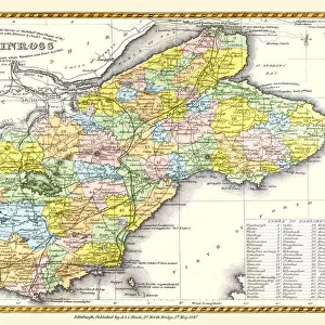
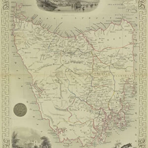
Canvas Print : Old Map of the Counties of Fife and Kinross from the Philips Handy Atlas of 1882


![]()
Canvas Prints from MapSeeker
Old Map of the Counties of Fife and Kinross from the Philips Handy Atlas of 1882
PHA014
Welcome to the Mapseeker Image library and enter an historic gateway to one of the largest on-line collections of Historic Maps, Nostalgic Views, Vista's and Panorama's from a World gone by.
Media ID 20348179
County Map County Map Of Scotland Historic Map Old County Map Old Scottish County Map Scottish County Map Fife Fifeshire Kinross
20"x16" (50x40cm) Canvas Print
"Step back in time with our captivating Canvas Print of the Old Map of Fife and Kinross from the Philips Handy Atlas of 1882, exclusive to Media Storehouse. This vintage map, sourced from MapSeeker, beautifully showcases the historical counties of Fife and Kinross. Each Canvas Print is meticulously crafted with attention to detail, allowing the intricate lines and textures of the map to truly shine. Elevate the aesthetic of your space while adding a touch of history with this unique piece. Order yours today and let the stories of the past come alive in your home."
Ready to hang Premium Gloss Canvas Print. Our archival quality canvas prints are made from Polyester and Cotton mix and stretched over a 1.25" (32mm) kiln dried knot free wood stretcher bar. Packaged in a plastic bag and secured to a cardboard insert for transit.
Canvas Prints add colour, depth and texture to any space. Professionally Stretched Canvas over a hidden Wooden Box Frame and Ready to Hang
Estimated Product Size is 50.8cm x 40.6cm (20" x 16")
These are individually made so all sizes are approximate
Artwork printed orientated as per the preview above, with landscape (horizontal) orientation to match the source image.
FEATURES IN THESE COLLECTIONS
> Europe
> United Kingdom
> Scotland
> Fife
> Related Images
> Europe
> United Kingdom
> Scotland
> Kinross-shire
> Europe
> United Kingdom
> Scotland
> Maps
> Europe
> United Kingdom
> Scotland
> Perth and Kinross
> Kinross
> Maps and Charts
> Early Maps
> Maps and Charts
> Related Images
> MapSeeker
> Maps from the British Isles
> Scotland and Counties PORTFOLIO
EDITORS COMMENTS
This stunning print showcases an exquisite piece of history - the Old Map of the Counties of Fife and Kinross from the Philips Handy Atlas of 1882. Steeped in Scottish heritage, this vintage county map offers a captivating glimpse into the past. With intricate details and elegant cartography, this old Scottish county map takes us on a journey through time. It reveals the boundaries and landscapes of Fife and Kinross, two counties that have played significant roles in Scotland's rich tapestry. The historical significance of this map is undeniable. It provides a unique perspective on how these regions were structured over a century ago, offering valuable insights into their development and evolution. From bustling towns to serene countryside, every corner is meticulously depicted with artistic precision. Whether you are a history enthusiast or simply appreciate the beauty of antique maps, this print will transport you back to an era long gone. Its faded colors evoke nostalgia while its fine craftsmanship captures your imagination. Displaying this historic map proudly in your home or office will not only add character but also spark conversations about Scotland's fascinating past. Let it serve as a reminder that our present is built upon layers of stories from those who came before us
MADE IN THE UK
Safe Shipping with 30 Day Money Back Guarantee
FREE PERSONALISATION*
We are proud to offer a range of customisation features including Personalised Captions, Color Filters and Picture Zoom Tools
SECURE PAYMENTS
We happily accept a wide range of payment options so you can pay for the things you need in the way that is most convenient for you
* Options may vary by product and licensing agreement. Zoomed Pictures can be adjusted in the Basket.