Canvas Print > Arts > Artists > T > John Tallis
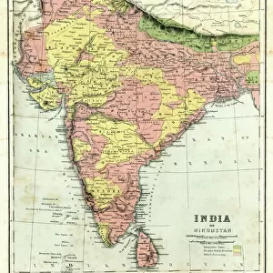
Canvas Print : British India 1851


![]()
Canvas Prints from MapSeeker
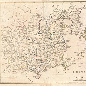
British India 1851
A fine facimile artworked from an antique original map of British India, issued as part of the 1851 edition of John Tallis and Companys " The Illustrated Atlas and Modern History of the World"
Welcome to the Mapseeker Image library and enter an historic gateway to one of the largest on-line collections of Historic Maps, Nostalgic Views, Vista's and Panorama's from a World gone by.
Media ID 20347368
© Mapseeker Publishing Ltd
John Tallis John Tallis Map Tallis Tallis Map British India
21"x14" (53x35cm) Canvas Print
Step back in time with our stunning Canvas Print of "British India 1851" by John Tallis and John Rapkin from MapSeeker. This exquisite facsimile artwork is meticulously reproduced from an original antique map, taken from the 1851 edition of John Tallis and Company's "The Illustrated Atlas". Transporting you back to a bygone era, this captivating print showcases the extensive British colonial territories in India during the mid-19th century. Add an air of historical sophistication to your home or office décor with this beautiful and authentic work of art.
Ready to hang Premium Gloss Canvas Print. Our archival quality canvas prints are made from Polyester and Cotton mix and stretched over a 1.25" (32mm) kiln dried knot free wood stretcher bar. Packaged in a plastic bag and secured to a cardboard insert for transit.
Canvas Prints add colour, depth and texture to any space. Professionally Stretched Canvas over a hidden Wooden Box Frame and Ready to Hang
Estimated Product Size is 35.6cm x 53.3cm (14" x 21")
These are individually made so all sizes are approximate
Artwork printed orientated as per the preview above, with portrait (vertical) orientation to match the source image.
FEATURES IN THESE COLLECTIONS
> Arts
> Artists
> T
> John Tallis
> Asia
> India
> Related Images
> Maps and Charts
> India
> Maps and Charts
> Related Images
> Maps and Charts
> World
> MapSeeker
> Maps of Asia and Middle East
> Maps of Countries in Asia PORTFOLIO
EDITORS COMMENTS
This stunning print showcases a fine facsimile artwork of an antique original map of British India from 1851. The map was originally issued as part of the prestigious 1851 edition of John Tallis and Company's "The Illustrated Atlas and Modern History of the World". With intricate details and exquisite craftsmanship, this old map provides a captivating glimpse into the historical geography of India during that era. It offers a fascinating visual representation of British India, depicting its vast territories, cities, rivers, mountains, and other significant landmarks. Created by renowned cartographers John Tallis and John Rapkin, this remarkable piece is not only a testament to their expertise but also serves as a valuable historical artifact. Its delicate lines and vibrant colors transport us back in time to an era when colonial powers were shaping the world. Whether you are an avid collector or simply appreciate the beauty and significance of vintage maps, this print is sure to be a cherished addition to your collection. Display it proudly on your wall or use it as an educational tool to explore the rich history embedded within each corner
MADE IN THE UK
Safe Shipping with 30 Day Money Back Guarantee
FREE PERSONALISATION*
We are proud to offer a range of customisation features including Personalised Captions, Color Filters and Picture Zoom Tools
SECURE PAYMENTS
We happily accept a wide range of payment options so you can pay for the things you need in the way that is most convenient for you
* Options may vary by product and licensing agreement. Zoomed Pictures can be adjusted in the Basket.