Canvas Print > Fine Art Storehouse > Map
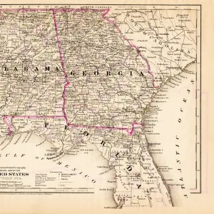
Canvas Print : United States South East map 1897


![]()
Canvas Prints from Fine Art Storehouse
United States South East map 1897
The World-Wide Atlas of Modern Geography, Political and Physical W. & A.K. Johnston - London 1897
Unleash your creativity and transform your space into a visual masterpiece!
THEPALMER
Media ID 14757120
© Roberto A Sanchez
Alabama Arkansas Atlas Country Geographic Area Earth Florida Usa Georgia Us State Louisiana Mississippi North Carolina Paper Sepia Toned South Carolina Tennessee Textured Effect World Map Retro Styled
20"x16" (50x40cm) Canvas Print
Step back in time with our vintage-inspired Canvas Print of the United States South East Map from 1897. This beautiful piece, sourced from the renowned Fine Art Storehouse, is taken from The World-Wide Atlas of Modern Geography, Political and Physical by W. & A.K. Johnston, London. The intricate details of this antique map, featuring the United States Southeast region during that era, are brought to life with our premium canvas printing process. Add a touch of history and character to your home or office décor with this captivating and unique piece.
Ready to hang Premium Gloss Canvas Print. Our archival quality canvas prints are made from Polyester and Cotton mix and stretched over a 1.25" (32mm) kiln dried knot free wood stretcher bar. Packaged in a plastic bag and secured to a cardboard insert for transit.
Canvas Prints add colour, depth and texture to any space. Professionally Stretched Canvas over a hidden Wooden Box Frame and Ready to Hang
Estimated Product Size is 50.8cm x 40.6cm (20" x 16")
These are individually made so all sizes are approximate
Artwork printed orientated as per the preview above, with landscape (horizontal) orientation to match the source image.
FEATURES IN THESE COLLECTIONS
> Fine Art Storehouse
> Map
> Historical Maps
> Fine Art Storehouse
> Map
> USA Maps
EDITORS COMMENTS
This print takes us back in time to the year 1897, showcasing a beautifully detailed map of the United States Southeast region. The vintage charm is evident in every aspect of this image, from its retro styling to the textured effect that gives it an aged and weathered appearance. The map itself is a true work of art, engraved with precision and care. It belongs to "The World-Wide Atlas of Modern Geography, Political and Physical" published by W. & A. K. Johnston in London during that era. Its sepia-toned hues add a touch of nostalgia, transporting us to a bygone era when cartography was both scientific and artistic. As we explore this antique piece further, we can identify various states within the Southeast region: Florida, South Carolina, North Carolina, Louisiana, Tennessee, Mississippi, Georgia US State (Georgia), Arkansas, and Alabama. Each state is meticulously outlined with intricate details that highlight their geographic boundaries. This print not only serves as a visual delight but also offers an opportunity for exploration and learning about our country's history through its physical geography. Whether you are an avid traveler or simply appreciate fine craftsmanship and historical artifacts like this one – THEPALMER has truly captured the essence of this remarkable piece from "The World-Wide Atlas. "
MADE IN THE UK
Safe Shipping with 30 Day Money Back Guarantee
FREE PERSONALISATION*
We are proud to offer a range of customisation features including Personalised Captions, Color Filters and Picture Zoom Tools
SECURE PAYMENTS
We happily accept a wide range of payment options so you can pay for the things you need in the way that is most convenient for you
* Options may vary by product and licensing agreement. Zoomed Pictures can be adjusted in the Basket.