Canvas Print > Europe > Italy > Lazio > Rome
Canvas Print : Floor plan of Palatine Hill in Rome, published in 1878


![]()
Canvas Prints from Fine Art Storehouse
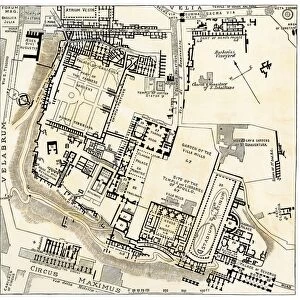
Floor plan of Palatine Hill in Rome, published in 1878
Floor plan of the archaeological remains of the Palatine Hill in Rome. The Palatine Hill (Latin: Mons Palatinus, Italian: Monte Palatino) is one of the seven hills of Rome and is the oldest inhabited part of the city. Already in the 10th century BC were found on the Palatine human settlements. Wood engraving, published in 1878
Unleash your creativity and transform your space into a visual masterpiece!
Media ID 13666875
© ZU_09
Ancient History Ancient Rome Blueprint Italian Culture Palate Plan Palatine Hill Roman Republic
20"x16" (50x40cm) Canvas Print
"Step back in time with our exquisite Canvas Print of the Floor Plan of Palatine Hill in Rome, a rare find from the Fine Art Storehouse. Published in 1878, this detailed and intricately designed floor plan offers a unique perspective into the archaeological remains of the Palatine Hill, one of Rome's Seven Hills. Each canvas print is meticulously crafted using high-quality materials, ensuring vibrant colors and sharp details that bring history to life in your home or office. Add a touch of timeless elegance and historical charm to your space with this stunning piece of art. Order now and let the story of Rome unfold before your eyes."
Ready to hang Premium Gloss Canvas Print. Our archival quality canvas prints are made from Polyester and Cotton mix and stretched over a 1.25" (32mm) kiln dried knot free wood stretcher bar. Packaged in a plastic bag and secured to a cardboard insert for transit.
Canvas Prints add colour, depth and texture to any space. Professionally Stretched Canvas over a hidden Wooden Box Frame and Ready to Hang
Estimated Product Size is 40.6cm x 50.8cm (16" x 20")
These are individually made so all sizes are approximate
Artwork printed orientated as per the preview above, with portrait (vertical) orientation to match the source image.
FEATURES IN THESE COLLECTIONS
> Arts
> Artists
> R
> Roman Roman
> Europe
> Italy
> Lazio
> Rome
> Europe
> Italy
> Related Images
> Historic
> Ancient civilizations
> Maps and Charts
> Early Maps
> Maps and Charts
> Italy
> Maps and Charts
> Related Images
> Fine Art Storehouse
> Map
> Historical Maps
> Fine Art Storehouse
> Map
> Italian Maps
EDITORS COMMENTS
This print showcases the floor plan of Palatine Hill in Rome, published in 1878. The intricate blueprint provides a glimpse into the archaeological remains of this historic site. Known as one of the seven hills of Rome, Palatine Hill holds immense significance as it is considered the oldest inhabited part of the city. Its rich history dates back to the 10th century BC when human settlements were discovered on its grounds. The wood engraving beautifully captures every detail, allowing us to explore and appreciate this ancient civilization's architectural marvels. This engraved image serves as a window into Italy's past, shedding light on its remarkable culture and heritage. The vertical composition emphasizes the grandeur and scale of these old ruins while highlighting their structural intricacies. As we delve into this meticulously crafted map, we are transported back in time, immersing ourselves in Roman Republic-era archaeology. With elements such as cartography and etching skillfully employed, this photograph offers an invaluable resource for historians and enthusiasts alike. It serves as a testament to our fascination with uncovering hidden stories from centuries gone by.
MADE IN THE UK
Safe Shipping with 30 Day Money Back Guarantee
FREE PERSONALISATION*
We are proud to offer a range of customisation features including Personalised Captions, Color Filters and Picture Zoom Tools
SECURE PAYMENTS
We happily accept a wide range of payment options so you can pay for the things you need in the way that is most convenient for you
* Options may vary by product and licensing agreement. Zoomed Pictures can be adjusted in the Basket.