Canvas Print > Africa > South Africa > Maps
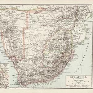
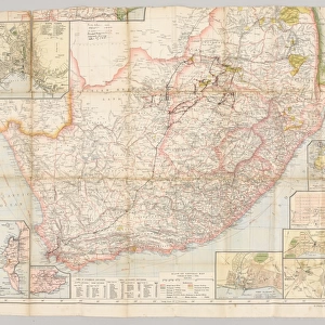
Canvas Print : Map of South Africa 1896


![]()
Canvas Prints from Fine Art Storehouse
Map of South Africa 1896
Andres Allgemeiner Handatlas - Bielefeld und Leipzig 1896
Unleash your creativity and transform your space into a visual masterpiece!
THEPALMER
Media ID 18356797
21"x14" (53x35cm) Canvas Print
Discover the rich history of South Africa with our stunning Canvas Print of the Map of South Africa 1896 by THEPALMER from our Media Storehouse Fine Art Collection. This intricately detailed map, taken from the Andres Allgemeiner Handatlas published in Bielefeld and Leipzig in 1896, makes a captivating addition to any room. Bring a piece of historical cartography into your home and transport yourself back in time with this beautiful and authentic work of art.
Ready to hang Premium Gloss Canvas Print. Our archival quality canvas prints are made from Polyester and Cotton mix and stretched over a 1.25" (32mm) kiln dried knot free wood stretcher bar. Packaged in a plastic bag and secured to a cardboard insert for transit.
Canvas Prints add colour, depth and texture to any space. Professionally Stretched Canvas over a hidden Wooden Box Frame and Ready to Hang
Estimated Product Size is 53.3cm x 35.6cm (21" x 14")
These are individually made so all sizes are approximate
Artwork printed orientated as per the preview above, with landscape (horizontal) orientation to match the source image.
FEATURES IN THESE COLLECTIONS
> Africa
> Related Images
> Africa
> South Africa
> Maps
> Africa
> South Africa
> Related Images
> Maps and Charts
> Related Images
> Fine Art Storehouse
> Map
> Historical Maps
EDITORS COMMENTS
This print showcases a remarkable piece of history, the "Map of South Africa 1896" from Andres Allgemeiner Handatlas. Dating back to the late 19th century, this map offers a fascinating glimpse into the intricate details and geographical features that defined South Africa during that era. With its rich colors and meticulous craftsmanship, it serves as both an artistic masterpiece and a valuable historical artifact. The map's origins in Bielefeld und Leipzig in 1896 add to its allure, highlighting the global interest in cartography at the time. As we explore this meticulously crafted artwork by THEPALMER from Fine Art Storehouse, we are transported back to an era when maps were not just navigational tools but also works of art. Every contour line, river system, and mountain range is intricately depicted on this vintage map. It invites us to embark on a journey through time as we trace the boundaries of provinces long forgotten or discover towns that have since transformed beyond recognition. The attention to detail is astonishing; one can almost feel the passion with which every stroke was made. Whether you are an avid historian or simply appreciate beautiful artistry, this print allows you to own a piece of South African history frozen in time. Hang it proudly on your wall and let it spark conversations about our ever-evolving world while serving as a reminder of how far we have come since those days captured so vividly on paper over a century ago.
MADE IN THE UK
Safe Shipping with 30 Day Money Back Guarantee
FREE PERSONALISATION*
We are proud to offer a range of customisation features including Personalised Captions, Color Filters and Picture Zoom Tools
SECURE PAYMENTS
We happily accept a wide range of payment options so you can pay for the things you need in the way that is most convenient for you
* Options may vary by product and licensing agreement. Zoomed Pictures can be adjusted in the Basket.