Canvas Print > Europe > Finland > Maps
Canvas Print : antique, archival, baltic, border, cartography, denmark, document, europe, european


![]()
Canvas Prints from Fine Art Storehouse
antique, archival, baltic, border, cartography, denmark, document, europe, european
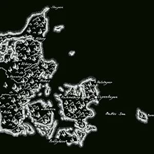
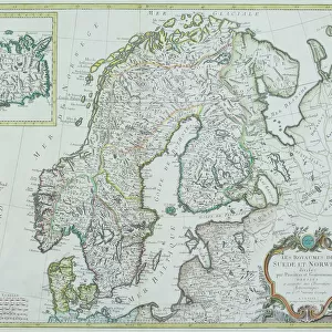
antique, archival, baltic, border, cartography, denmark, document, europe, european, finland, geography, historic, historical, latitude, longitude, map, nobody, north, norway, region, scale, scandinavia, sea, sweden, vignette, vintage, words, Maps of Denmark, 87680500
Unleash your creativity and transform your space into a visual masterpiece!
Hemera Technologies
Media ID 14537646
© Getty Images
Baltic Border Denmark Document Finland Geography Latitude Longitude North Norway Region Scale Scandinavia Sweden Vignette Words
20"x16" (50x40cm) Canvas Print
Step back in time with our Media Storehouse Canvas Prints featuring exquisite antique maps from Hemera Technologies' Fine Art Storehouse. These archival-quality prints showcase intricate cartography of Europe, including Baltic regions such as Denmark, Finland, and Norway. With intricate border designs and historic documentation, each print adds a touch of old-world charm to any space. Explore the rich history of Europe with these detailed maps, complete with latitude and longitude markings. Perfect for those who appreciate the beauty of historic geography and the nostalgia of bygone eras.
Ready to hang Premium Gloss Canvas Print. Our archival quality canvas prints are made from Polyester and Cotton mix and stretched over a 1.25" (32mm) kiln dried knot free wood stretcher bar. Packaged in a plastic bag and secured to a cardboard insert for transit.
Canvas Prints add colour, depth and texture to any space. Professionally Stretched Canvas over a hidden Wooden Box Frame and Ready to Hang
Estimated Product Size is 50.8cm x 40.6cm (20" x 16")
These are individually made so all sizes are approximate
Artwork printed orientated as per the preview above, with landscape (horizontal) orientation to match the source image.
FEATURES IN THESE COLLECTIONS
> Europe
> Denmark
> Related Images
> Europe
> Finland
> Related Images
> Europe
> Norway
> Related Images
> Europe
> Related Images
> Fine Art Storehouse
> Map
> Denmark Maps
> Fine Art Storehouse
> Map
> Historical Maps
EDITORS COMMENTS
This print showcases a remarkable piece of history - an antique map of Denmark. With its archival quality, this baltic-bordered cartography document takes us back to the European region during a bygone era. The intricate details and precise latitude and longitude markings on this vintage map offer a glimpse into the geography of Scandinavia, encompassing not only Denmark but also Norway, Sweden, Finland, and the surrounding areas. The faded vignette effect adds an extra touch of nostalgia to this historic artifact. As we explore the delicate lines that outline each country's borders and trace the meandering coastline along the Baltic Sea, we can't help but appreciate how maps like these were once essential tools for navigation and understanding our world. This particular print from Hemera Technologies captures the essence of Danish heritage with its exquisite craftsmanship. It reminds us that even in today's digital age, there is still something enchanting about holding a tangible piece of history in our hands. Whether you're an avid collector or simply fascinated by Europe's past, this vintage map serves as both a decorative piece and a window into centuries gone by. Let it transport you to another time as you marvel at the artistry behind Maps of Denmark.
MADE IN THE UK
Safe Shipping with 30 Day Money Back Guarantee
FREE PERSONALISATION*
We are proud to offer a range of customisation features including Personalised Captions, Color Filters and Picture Zoom Tools
SECURE PAYMENTS
We happily accept a wide range of payment options so you can pay for the things you need in the way that is most convenient for you
* Options may vary by product and licensing agreement. Zoomed Pictures can be adjusted in the Basket.