Canvas Print > Fine Art Storehouse > The Magical World of Illustration > Palmer Illustrated Collection
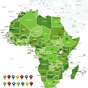
Canvas Print : Africa map 1875


![]()
Canvas Prints from Fine Art Storehouse
Africa map 1875
The Independent Course Comprehensive Geography by James Monteith, A.S. Barnes & Co, New York & Chicago 1875
Unleash your creativity and transform your space into a visual masterpiece!
THEPALMER
Media ID 13612253
© This content is subject to copyright
Central Africa East Africa Globe Navigational Equipment Madagascar Paper Sahara Sahara Desert Drawing Art Product
20"x16" (50x40cm) Canvas Print
Step back in time with our exquisite Africa Map 1875 Canvas Print from The Palmer Collection at Media Storehouse. This captivating piece, taken from The Independent Course of Comprehensive Geography by James Monteith, published by A.S. Barnes & Co in 1875, showcases an intriguing and historic perspective of Africa. The vibrant colors and high-quality finish of our canvas prints bring this remarkable image to life, making it an excellent addition to any home or office decor. Travel back in time and explore the rich history of Africa with this stunning and authentic piece of art.
Ready to hang Premium Gloss Canvas Print. Our archival quality canvas prints are made from Polyester and Cotton mix and stretched over a 1.25" (32mm) kiln dried knot free wood stretcher bar. Packaged in a plastic bag and secured to a cardboard insert for transit.
Canvas Prints add colour, depth and texture to any space. Professionally Stretched Canvas over a hidden Wooden Box Frame and Ready to Hang
Estimated Product Size is 40.6cm x 50.8cm (16" x 20")
These are individually made so all sizes are approximate
Artwork printed orientated as per the preview above, with portrait (vertical) orientation to match the source image.
FEATURES IN THESE COLLECTIONS
> Fine Art Storehouse
> The Magical World of Illustration
> Palmer Illustrated Collection
> Fine Art Storehouse
> Map
> Historical Maps
> Fine Art Storehouse
> Map
> USA Maps
> Fine Art Storehouse
> Ultimate Earth Prints
> Amazing Deserts
EDITORS COMMENTS
This print takes us back in time to the year 1875, when James Monteith's "The Independent Course Comprehensive Geography" was published. The image showcases a meticulously engraved map of Africa, offering a glimpse into the continent's geographical features and divisions during that era. The intricate details of this vintage map are truly remarkable. From the vast Sahara Desert stretching across North Africa to the lush landscapes of Central and East Africa, every contour is etched with precision. Madagascar stands out as an isolated island off the eastern coast, adding to the allure of this historical piece. The artistry behind this engraving is evident in its fine lines and delicate shading. It serves as a testament to the skillful craftsmanship prevalent in cartography during those times. This antique illustration transports us back to an age when maps were not just navigational tools but also works of art. Displayed on aged paper, this print exudes a sense of nostalgia and authenticity. Its vertical orientation allows for easy appreciation of each region's unique characteristics while evoking a sense of exploration and discovery. "The Independent Course Comprehensive Geography" by James Monteith offers viewers an opportunity to delve into Africa's past through its physical geography. As we gaze upon this enchanting artwork by THEPALMER from Fine Art Storehouse, we can't help but marvel at how much our understanding and perception of our world has evolved since 1875
MADE IN THE UK
Safe Shipping with 30 Day Money Back Guarantee
FREE PERSONALISATION*
We are proud to offer a range of customisation features including Personalised Captions, Color Filters and Picture Zoom Tools
SECURE PAYMENTS
We happily accept a wide range of payment options so you can pay for the things you need in the way that is most convenient for you
* Options may vary by product and licensing agreement. Zoomed Pictures can be adjusted in the Basket.